
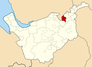
Tong is a ward within the City of Bradford Metropolitan District Council, West Yorkshire, England, named after Tong village which is its oldest settlement. The population at the 2011 Census was 20,608.

Chesterton is a suburb in the northeast corner of Cambridge, in the Cambridge district, in the county of Cambridgeshire, England, 2 miles (3.2 km) north of Cambridge station, on the north bank of the River Cam.

Wyre is a local government district with borough status on the coast of Lancashire, England. The council is based in Poulton-le-Fylde and the borough also contains the towns of Cleveleys, Fleetwood, Garstang, Preesall and Thornton, along with numerous villages and surrounding rural areas. Some of the borough's built-up areas form part of the wider Blackpool urban area. Eastern parts of the borough lie within the Forest of Bowland, a designated Area of Outstanding Natural Beauty.
Burnham-on-Sea and Highbridge is a civil parish in Somerset, England. It has a population of 19,576. The parish contains the towns Burnham-on-Sea and Highbridge, which share a town council.
Cheadle and Gatley was an administrative district in Cheshire, England, from 1886 until 1974. It was a local government district from 1886 to 1894 and then an urban district from 1894 until 1974.
Turton Urban District was, from 1873 to 1974, a local government district centred on the historical area of Turton in the administrative county of Lancashire, England.

Queensbury and Shelf was an urban district in the West Riding of Yorkshire from 1937 to 1974. The district was formed by a County Review Order by the amalgamation of Queensbury and Shelf urban districts. It contained only the civil parish of Queensbury and Shelf. In 1961 the district had a population of 9306.
Bentley with Arksey is a former civil parish (1866–1974) and urban district (1911–1974) adjacent to the town of Doncaster in the West Riding of Yorkshire.

Norden is a village in the Metropolitan Borough of Rochdale, in Greater Manchester, England. It was historically part of Lancashire until 1974. It is situated on the western outskirts of the town of Rochdale.

Smallthorne is an area in the city of Stoke-on-Trent in Staffordshire, England. It is in the north-east of the city, near Burslem. Smallthorne borders Bradeley and Chell in the north, Norton-in-the-Moors in the east, Sneyd Green in the south, and Burslem in the west.
Wolstanton was a rural district in Staffordshire, England from 1894 to 1904. It was created by the Local Government Act 1894 based on Wolstanton rural sanitary district.
Billinge was, from 1872 to 1974, a local government district in the administrative county of Lancashire, England.

The Municipal Borough of Farnworth was a local government district centred on the town of Farnworth in the administrative county of Lancashire, England. A local board of health had been established for Farnworth in 1863, which was reconstituted as an urban district in 1899, before being granted a charter of incorporation to become a municipal borough in 1939. Following abolition of the local authority in 1974, Farnworth became an unparished area of the Metropolitan Borough of Bolton in Greater Manchester.
Norton le Moors is in the north-east of the city of Stoke-On-Trent, Staffordshire, England, mostly within the city boundary, with the rest in the Staffordshire Moorlands district.

Tyldesley cum Shakerley Urban District and its successor Tyldesley Urban District was, from 1894 to 1974, a local government district in Lancashire, England.
Blackrod was, from 1872 to 1974, a local government district centred on the village of Blackrod in the administrative county of Lancashire, England.
Horwich was, from 1872 to 1974, a local government district centred on the town of Horwich in the administrative county of Lancashire, England.
Kearsley was, from 1865 to 1974, a local government district centred on the town of Kearsley in the administrative county of Lancashire, England.
Little Lever was, from 1872 to 1974, a local government district centred on the large village of Little Lever in the administrative county of Lancashire, England.

Westhoughton was, from 1872 to 1974, a local government district centred on the town of Westhoughton in the administrative county of Lancashire, England.