
The Reese River is a 181-mile-long (291 km) tributary of the Humboldt River, located in central Nevada in the western United States.
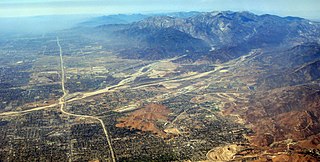
Lytle Creek, California, is an approximately 18-mile-long (29 km) stream in southwestern San Bernardino County near the city of San Bernardino. It is a tributary of Warm Creek, a tributary of the Santa Ana River. The Mormon settlers of San Bernardino named the stream "Lytle Creek" after their leader, Captain Andrew Lytle.
There are several lakes named Mud Lake within the U.S. state of Nevada.

Temescal Creek is an approximately 29-mile-long (47 km) watercourse in Riverside County, in the U.S. state of California. Flowing primarily in a northwestern direction, it connects Lake Elsinore with the Santa Ana River. It drains the eastern slopes of the Santa Ana Mountains on its left and on its right the western slopes of the Temescal Mountains along its length. With a drainage basin of about 1,000 square miles (2,600 km2), it is the largest tributary of the Santa Ana River, hydrologically connecting the 720-square-mile (1,900 km2) San Jacinto River and Lake Elsinore watersheds to the rest of the Santa Ana watershed. However, flowing through an arid rain shadow zone of the Santa Ana Mountains, and with diversion of ground water for human use, the creek today is ephemeral for most of its length, except for runoff from housing developments and agricultural return flows.
San Juan or Upper Camp is a ghost town that was a mining camp of the Eldorado Mining District. It was located in the upper reach of El Dorado Canyon, just below the present day location of Nelson in Clark County, Nevada.
Trunk Creek is a stream in the U.S. state of South Dakota.
Sweden is an unincorporated community in Douglas County, Missouri. Sweden lies in the south-central part of the county. The former Sweden store is located on Missouri Route 14 one half mile east of the intersection of Route 14 and State Route P. Sweden community church and cemetery lie one quarter mile north of the former store location on a county road.
Sturges is an unincorporated community in Livingston County, in the U.S. state of Missouri.
Bernice is an extinct town in Churchill County, in the U.S. state of Nevada. It was approximately 20 miles (32 km) northeast of Dixie Valley.
Boyer is an extinct town in Churchill County, in the U.S. state of Nevada. The GNIS classifies it as a populated place.
Edwards Creek is a stream in the U.S. state of Nevada.
Magruder Mountain is a summit in the U.S. state of Nevada. The elevation is 9,035 feet (2,754 m).
Birch is an extinct town in Eureka County, in the U.S. state of Nevada.
Rebel Creek is a stream in the U.S. state of Nevada.
Rebel Creek is an unincorporated community in Humboldt County, in the U.S. state of Nevada.
Willow Point is an extinct town in Humboldt County, in the U.S. state of Nevada. Willow Point is located in Paradise Valley, south of the town of Paradise Valley and about 20 miles northeast of Winnemucca.
Mount Prometheus is a summit in the U.S. state of Nevada. The elevation is 7,985 feet (2,434 m).
Telegraph Peak is a summit in the U.S. state of Nevada. The elevation is 8,537 feet (2,602 m).
Emigrant Valley is a valley in the U.S. state of Nevada.
Millett is an extinct town in Nye County, in the U.S. state of Nevada. The GNIS classifies it as a populated place.


