Related Research Articles

The Belle Fourche River is a tributary of the Cheyenne River, approximately 290 miles (470 km) long, in the U.S. states of Wyoming and South Dakota. It is part of the Mississippi River watershed via the Cheyenne and Missouri rivers. In the latter part of the 19th century, the Belle Fourche River was known as the North Fork of the Cheyenne River. Belle Fourche is a name derived from French meaning "beautiful fork".
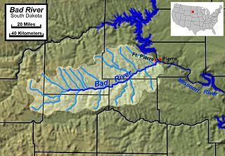
The Bad River is a tributary of the Missouri River, approximately 161 miles (259 km) long, in central South Dakota in the United States. The river is formed at Philip, South Dakota, by the confluence of its North and South forks. The North Fork Bad River rises in eastern Pennington County and flows 51 miles (82 km) east-southeast to Philip, while the South Fork Bad River rises at the confluence of Whitewater Creek and Big Buffalo Creek in Jackson County, within the Buffalo Gap National Grassland, and flows 36 miles (58 km) northeast to Philip. The main stem of the Bad River flows east-northeast from Philip, passing Midland and Capa. It joins the Missouri at Fort Pierre. The Bad drainage basin is about 3,000 square miles (7,800 km2) and is located south of the Cheyenne River in the Pierre Hills and Southern Plateaus.
The Little White River is a tributary of the White River, approximately 234 miles (377 km) long, in south central South Dakota in the United States.

The Kentucky River is a tributary of the Ohio River in Kentucky, United States. The 260-mile (420 km) river and its tributaries drain much of eastern and central Kentucky, passing through the Eastern Coalfield, the Cumberland Mountains, and the Bluegrass region. Its watershed encompasses about 7,000 square miles (18,000 km2), and it supplies drinking water to about one-sixth of the population of the state.
The Clarks River, named for William Clark of the Lewis and Clark Expedition, is a 66.7-mile-long (107.3 km) tributary of the Tennessee River in the Jackson Purchase region of western Kentucky. Below the West Fork Clarks River, the river has a mean annual discharge of 368 cubic feet per second. This figure is obtained by combining the average discharge of the Clarks River at Benton, and the average discharge of the West Fork at Brewers.

The Snake River is a 126-mile-long (203 km) tributary of the Niobrara River. Entirely located within the Sandhills of north-central Nebraska, the Snake River rises near the eastern edge of Sheridan County. It flows eastward into Cherry County and passes along the southern edge of Samuel R. McKelvie National Forest. On the southeast edge of the national forest, the river is dammed to form Merritt Reservoir. At this point, the river makes a sharp turn to the north. At Burge, the river has a mean annual discharge of 158 cubic feet per second.
The Fabius River is a 3.5-mile-long (5.6 km) tributary of the Mississippi River in northeastern Missouri in the United States. It is formed near its mouth by the confluence of the North Fabius River and the South Fabius River. The North Fabius River also flows through southeastern Iowa. The Middle Fabius River joins the North Fabius 8.9 miles (14.3 km) upstream of that river's mouth.

The Nolin River is a 104-mile-long (167 km) tributary of the Green River in central Kentucky in the United States. Via the Green and Ohio rivers, it is a part of the watershed of the Mississippi River.

The Deep Fork River is an Oklahoma tributary of the North Canadian River. The headwaters flow from northern Oklahoma City and the river empties into the North Canadian River, now impounded by Lake Eufaula.
The Beech Fork, or Beech Fork River, is a 112-mile-long (180 km) river in central Kentucky in the United States. It is a tributary of the Rolling Fork of the Salt River, with its waters flowing eventually to the Ohio River and ultimately the Mississippi River.

Jacks Fork is one of two rivers in Missouri that are part of the Ozark National Scenic Riverways system.

The Barren River is a 135-mile-long (217 km) river in Southcentral Kentucky, United States, and a tributary of the Green River. The watershed of the Green River is the largest of the twelve major river watersheds in Kentucky. The Barren River rises near the Tennessee border in Monroe County and flows into the Green in northeast Warren County. The drainage basin consists of Southcentral Kentucky and north-central Tennessee.

The Dismal River is a winding 71.9-mile-long (115.7 km) river in the state of Nebraska. It is formed by the confluence of two forks, one of which has its origins in Grant County and the other in Hooker County. The forks meet near Nebraska Highway 97 between Mullen and Tryon. From here the Dismal River flows east-southeast into Thomas County, crossing U.S. Highway 83 south of Thedford. Passing just south of the Nebraska National Forest, it turns slightly to the northeast before its confluence with the Middle Loup River just East of Dunning in Blaine County.
Raccoon Creek is a 114-mile-long (183 km) stream that drains parts of five Ohio counties in the United States. It originates in Hocking County, Ohio. It flows through Vinton County and Gallia County and a corner of Meigs County. Its largest tributary, Little Raccoon Creek, arises in Jackson County. The watershed also includes part of Athens County, drained by another tributary, Hewett Fork. The other major tributaries are Elk Fork, located entirely in Vinton County, and Brushy Fork, which is mostly in Vinton County with a small area in Hocking County.
The Clear Fork is a 42.8-mile-long (68.9 km) tributary of the Cumberland River in Kentucky and Tennessee. By the Cumberland and Ohio rivers, it is part of the Mississippi River watershed.
Skeleton Creek is a stream in Logan, Kingfisher and Garfield counties, Oklahoma, in the United States.
Chattanooga Creek is a stream in Walker County, Georgia and Hamilton County, Tennessee.
Medicine Creek is a stream in Grundy, Livingston, Putnam, and Sullivan counties of the U.S. state of Missouri. It is a tributary to the Grand River.
Cadron Creek is a stream in the U.S. state of Arkansas. It originates in central Cleburne County, southeast of Pearson and flows west-southwest past Quitman, where it enters Van Buren County briefly then into Faulkner County just north of the town of Guy. Past Twin Groves the stream turns more southerly. Downstream from Mallettown, the creek forms the boundary between Faulkner and Conway County. Ultimately it flows into the Arkansas River just west of the city of Conway. Interstate 40 crosses it at the lower reaches of the creek just above the confluence with the Arkansas River.

Bear Creek is a stream in the U.S. states of Mississippi and Alabama. The stream flows approximately 80 miles (130 km) before it empties into the Tennessee River.
References
35°18′22″N88°07′07″W / 35.3061893°N 88.1186437°W
| | This Hardin County, Tennessee geography–related article is a stub. You can help Wikipedia by expanding it. |