
The Bois de Sioux River drains Lake Traverse, the southernmost body of water in the Hudson Bay watershed of North America. It is a tributary of the Red River of the North and defines part of the western border of the U.S. state of Minnesota, and the eastern borders of North Dakota and South Dakota. It is about 41 miles (66 km) in length.

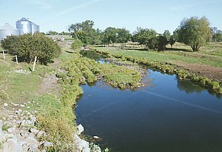
The Blue Earth River is a tributary of the Minnesota River, 108 miles (174 km) long, in southern Minnesota in the United States. Two of its headwaters tributaries, the Middle Branch Blue Earth River and the West Branch Blue Earth River, also flow for short distances in northern Iowa. By volume, it is the Minnesota River's largest tributary, accounting for 46% of the Minnesota's flow at the rivers' confluence in Mankato. Via the Minnesota River, the Blue Earth River is part of the watershed of the Mississippi River, draining an area of 3,486 square miles (9,030 km2) in an agricultural region. Ninety percent of the river's watershed is in Minnesota. It is a Minnesota Department of Natural Resources designated Water Trail.

The Little Minnesota River is a 71.4-mile-long (114.9 km) headwaters tributary of the Minnesota River in northeastern South Dakota and west-central Minnesota in the United States. Via the Minnesota River, it is part of the Mississippi River watershed.

The Sunrise River is a 39.1-mile-long (62.9 km) tributary of the St. Croix River in east–central Minnesota in the United States. It originates within the boundaries of the Comfort Lake - Forest Lake Watershed District near the city of Forest Lake in Washington County. It's headwaters are considered several small tributaries that flow into and contribute to Forest Lake, the longest of which is the Washington Judicial Ditch 6. From the outflow from Forest Lake, the river flows north, accepting the South Branch from the west near the city of Wyoming, and continues north into Mud Lake, where the West Branch, which rises in southeast Isanti County and briefly enters Anoka County, joins it near the city of Stacy. From Stacy it flows generally north-northwest through Chisago County to meet the St. Croix River within Wild River State Park near the communities of Sunrise and Almelund. Not far upstream from its mouth, the Sunrise collects its North Branch, which rises in Isanti County and flows through the city of North Branch.

The Turtle River is a 74.9-mile-long (120.5 km) tributary of the Red River of the North in northeastern North Dakota in the United States. It flows for almost its entire length in Grand Forks County. Via the Red River, Lake Winnipeg and the Nelson River, the Turtle River is part of the watershed of Hudson Bay.
The Elk River is an 84.0-mile-long (135.2 km) river in east-central Minnesota in the United States. It is a tributary of the Mississippi River, draining a watershed of 630 square miles (1,600 km2).
The Middle River is a tributary of the Snake River in northwestern Minnesota in the United States. It flows for its entire length in Marshall County.

The Wild Rice River is a tributary of the Red River of the North in northwestern Minnesota in the United States. It is 183 miles (295 km) long. Via the Red River, Lake Winnipeg and the Nelson River, it is part of the watershed of Hudson Bay. It is one of two Red River tributaries with the same name, the other being the Wild Rice River of North Dakota.

The Snake River is a 104-mile-long (167 km) tributary of the St. Croix River in east-central Minnesota in the United States. It is one of three streams in Minnesota with this name. Its name is a translation from the Ojibwa Ginebigo-ziibi, after the Dakota peoples who made their homes along this river. Kanabec County's name is derived from the Ojibwe word for this river.
The Knife River is a 27.4-mile-long (44.1 km) tributary of the Snake River in east-central Minnesota in the United States. It is one of three streams in Minnesota with this name. Its name is a translation from the Dakota Isaanti. Knife Lake and Santee Sioux are named after this river. In turn Isanti County is named after the Santee Sioux.
The Thief River is a 40.3-mile-long (64.9 km) tributary of the Red Lake River in northwestern Minnesota in the United States. Via the Red Lake River, the Red River of the North, Lake Winnipeg and the Nelson River, it is part of the watershed of Hudson Bay.
The Mustinka River is a tributary of Lake Traverse, 68 mi (109 km) long, in western Minnesota in the United States. Via Lake Traverse, the Bois de Sioux River, the Red River of the North, Lake Winnipeg, and the Nelson River, it is part of the watershed of Hudson Bay. The river drains an area of 909 square miles (2,350 km2).
The Shell Rock River is a 113-mile-long (182 km) tributary of the West Fork Cedar River in southern Minnesota and northern Iowa in the United States. Via the Cedar and Iowa rivers, it is part of the Mississippi River watershed.

The Rock River is a tributary of the Big Sioux River, about 144 miles (232 km) long, in southwestern Minnesota and northwestern Iowa in the United States. Via the Big Sioux and Missouri rivers, it is part of the watershed of the Mississippi River. The river's name comes from a prominent rocky outcrop about 175 feet high of reddish-gray Sioux Quartzite, about 3 miles (5 km) north of Luverne. The outcrop of quartzite is contained in Minnesota's Blue Mounds State Park.

The Chippewa River is a 153-mile-long (246 km) tributary of the Minnesota River in western and southwestern Minnesota in the United States. Via the Minnesota River, it is part of the watershed of the Mississippi River.
The Roseau River is a 214-mile-long (344 km) tributary of the Red River of the North, in southern Manitoba in Canada and northwestern Minnesota in the United States. Via the Red River, Lake Winnipeg and the Nelson River, it is part of the watershed of Hudson Bay.
The Shell River is a 47.8-mile-long (76.9 km) tributary of the Crow Wing River in north-central Minnesota in the United States. Via the Crow Wing River, it is part of the watershed of the Mississippi River, draining a rural region.
Grand Marais Creek is a 41.1-mile-long (66.1 km) tributary of the Red River of the North in northwestern Minnesota, the United States. Via the Red River, Lake Winnipeg, and the Nelson River, it is part of the Hudson Bay watershed.

The Dickey River is a stream on the Olympic Peninsula in the U.S. state of Washington. It has three main forks, the East Fork, West Fork, and Middle Fork Dickey Rivers. The main stem is formed by the confluence of the East and West Forks. The river and its forks rise in the northwestern part of the Olympic Peninsula and flow generally south and west to join the Quillayute River near its mouth on the Pacific Ocean.
