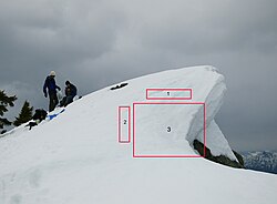
 A cornice of snow about to fall. Cracks in the snow are visible in area (1). Area (3) fell soon after this picture was taken, leaving area (2) as the new edge.
 A piece of snow cornice which has fallen off a ridge in early spring
 The summit of San Jacinto Peak covered by a cornice formed by wind-blown snow
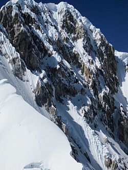 Massive snow cornices line the summit ridge of Siula Grande, and are a characteristic feature of this peak.
 Alternating cornices on the Rochefort-Crest in the Mont Blanc area in the Alps—always overhanging above the steeper face of the crest

A snow cornice or simply cornice (from the Italian cornice meaning "ledge") is an overhanging edge of snow on a ridge or the crest of a mountain and along the sides of gullies.


