Jewish temple may refer to:
Saddle Mountain may refer to:
Vishnu is a god in Hinduism.
The Temple of Isis, also known as an Iseum or Iseion, may refer to:
Al-Aqsa mosque compound, also known as al-Masjid al-Aqṣā, is a religious site in Jerusalem located on the area of land known as both the Temple Mount and Haram al-Sharif by Jews and Muslims respectively.
The Holy Grail is a mystical object in the Arthurian legend.
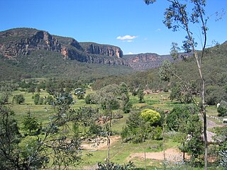
The Capertee Valley is a large canyon in New South Wales, Australia, 135 km (84 mi) north-west of Sydney that is noted to be the second widest of any canyon in the world, exceeding The Grand Canyon. It is located 135 km (84 mi) kilometres north-west of Sydney, between Lithgow and Mudgee, in the Central Tablelands, just above the Blue Mountains.
Santa Ana or Santa Anna may refer to:
Buckskin Mountain is a 16-mile (26 km) mountain ridge that spans from Coconino County, Arizona to Kane County, Utah in the United States, that is divided almost equally between the two counties.

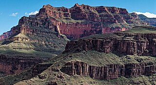
Isis Temple is a prominence in the Grand Canyon, Arizona, Southwestern United States. It is located below the North Rim and adjacent to the Granite Gorge along the Colorado River. The Trinity Creek and canyon flow due south at its west border; its north, and northeast border/flank is formed by Phantom Creek and canyon, a west tributary of Bright Angel Creek; the creeks intersect about 3 mi (4.8 km) southeast, and 1.0 mi (1.6 km) north of Granite Gorge. The Isis Temple prominence, is only about 202 ft (62 m) lower than Grand Canyon Village, the main public center on Grand Canyon’s South Rim.

The Dox Formation, also known as the Dox Sandstone, is a Mesoproterozoic rock formation that outcrops in the eastern Grand Canyon, Coconino County, Arizona. The strata of the Dox Formation, except for some more resistant sandstone beds, are relatively susceptible to erosion and weathering. The lower member of the Dox Formation consists of silty-sandstone and sandstone, and some interbedded argillaceous beds, that form stair-stepped, cliff-slope topography. The bulk of the Dox Formation typically forms rounded and sloping hill topography that occupies an unusually broad section of the canyon.
Sycamore Canyon may refer to:

The Devonian Temple Butte Formation, also called Temple Butte Limestone, outcrops through most of the Grand Canyon of Arizona, USA; it also occurs in southeast Nevada. Within the eastern Grand Canyon, it consists of thin, discontinuous and relatively inconspicuous lenses that fill paleovalleys cut into the underlying Muav Limestone. Within these paleovalleys, it at most, is only about 100 feet (30 m) thick at its maximum. Within the central and western Grand Canyon, the exposures are continuous. However, they tend to merge with cliffs of the much thicker and overlying Redwall Limestone.
Temple Mountain or temple mountain may refer to:

Solomon Temple is a 5,121-foot-elevation (1,561-meter) summit located in the Grand Canyon, in Coconino County of northern Arizona, USA. It is situated four miles north of Moran Point, 3.5 miles east of Newberry Butte, and 1.5 mile southeast of Rama Shrine, its nearest higher neighbor. Topographic relief is significant as it rises 2,500 feet above the Colorado River in less than one mile.
Grand Scenic Divide is a 5,667-foot-elevation (1,727-meter) ridge located in the Grand Canyon, in Coconino County of northern Arizona, Southwestern United States. It is situated immediately north of Fossil Mountain, and 1.5 mile east of Mount Huethawali. Surrounded by Bass and Serpentine Canyons, topographic relief is significant as it rises over 3,400 feet above the nearby Colorado River in 1.5 mile. It is composed of strata of the Pennsylvanian-Permian Supai Group. Further down are strata of the cliff-forming Mississippian Redwall Limestone, and Cambrian Tonto Group. According to the Köppen climate classification system, Grand Scenic Divide is located in a cold semi-arid climate zone. The normal approach to the ridge is made via the South Bass Trail, and from the top the view includes Masonic Temple, Holy Grail Temple, Dox Castle, King Arthur Castle, Evans Butte, Sagittarius Ridge, and Scorpion Ridge.
This page is based on this
Wikipedia article Text is available under the
CC BY-SA 4.0 license; additional terms may apply.
Images, videos and audio are available under their respective licenses.