
Holborn Viaduct is a road bridge in London and the name of the street which crosses it. It links Holborn, via Holborn Circus, with Newgate Street, in the City of London financial district, passing over Farringdon Street and the subterranean River Fleet. The viaduct spans the steep-sided Holborn Hill and the River Fleet valley at a length of 1,400 feet (430 m) and 80 feet (24 m) wide. City surveyor William Haywood was the architect and the engineer was Rowland Mason Ordish.

South Somerset is a local government district in Somerset, England.

Castle Cary is a small market town and civil parish in south Somerset, England, 5 miles (8 km) north west of Wincanton and 8 miles (12.9 km) south of Shepton Mallet, at the foot of Lodge Hill and on the River Cary, a tributary of the Parrett.

The Jubilee River is a hydraulic channel in southern England. It is 11.6 km (7.2 mi) long and is on average 45 metres wide. It was constructed in the late 1990s and early 2000s to take overflow from the River Thames and so alleviate flooding to areas in and around the towns of Maidenhead, Windsor, and Eton in the counties of Berkshire and Buckinghamshire. It achieves this by taking water from the left bank of the Thames upstream of Boulter's Lock near Maidenhead and returning it via the north bank downstream of Eton, Berkshire. Although successful in its stated aims, residents of villages downstream claim it has increased flooding.

The Bristol Harbour Railway is a heritage railway in Bristol, England operated by Bristol Museums Galleries & Archives. It runs for approximately 1 mile (1.6 km) along the south side of Bristol Harbour, starting at M Shed, stopping at the SS Great Britain, and ending at B Bond Warehouse, one of the large tobacco warehouses beside Cumberland Basin (51.4466°N 2.6213°W).

The River Cary is a river in Somerset, England.
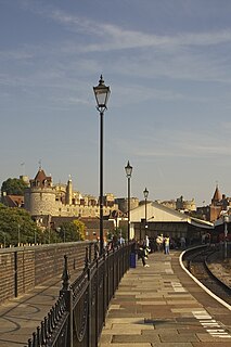
Windsor & Eton Central station is one of two terminal stations serving the town of Windsor, Berkshire, England. Although a small part is still a railway station, most of the station building has been converted into a tourist-oriented shopping centre, called Windsor Royal Shopping. It is situated on the High Street, almost immediately opposite Castle Hill, the main public entrance to Windsor Castle.

Somerton and Frome is a constituency represented in the House of Commons of the UK Parliament since 2015 by David Warburton of the Conservative Party.

Richmond Railway Bridge in Richmond, south-west London crosses the River Thames immediately upstream of Twickenham Bridge. It carries National Rail services operated by South Western Railway on the Waterloo to Reading Line, and lies between Richmond and St. Margarets stations.

The St. Julian's railway bridge is a crossing of the River Usk close to the city of Newport, South Wales. It was opened in 1874 by the Pontypool, Caerleon and Newport Railway and currently carries the Welsh Marches Line across the river in a north—south direction. Due to the meanderings of the river, all the other crossings are east—west.

The Digswell Viaduct, also called Welwyn Viaduct, is a railway viaduct that carries the East Coast Main Line over the River Mimram and is a prominent local landmark. It is located between Welwyn Garden City and Digswell. It is just to the south of Welwyn North railway station.
The Grimstone Viaduct is a railway bridge on the Castle Cary-Weymouth "Heart of Wessex" line. It passes over the road from Grimstone to Sydling St. Nicholas and Sydling Water flows underneath it. It is in the hamlet of Grimstone at the western edge of the parish of Stratton, Dorset.

Mont Sainte-Victoire is a series of oil paintings by the French artist Paul Cézanne.

Penallt Viaduct is a viaduct that formerly carried the Wye Valley Railway over the River Wye, which at this location forms the border between England (Gloucestershire) and Wales (Monmouthshire). The 14-mile Wye Valley Railway opened on 1 November 1876.

The Exeter–Plymouth line, also called the South Devon Main Line, is a central part of the trunk railway line between London Paddington and Penzance in the southern United Kingdom. It is a major branch of the Great Western Main Line and runs from Exeter to Plymouth, from where it continues as the Cornish Main Line. It was one of the principal routes of the Great Western Railway which in 1948 became part of the Western Region of British Railways and are now part of the Network Rail system.

The Bromford Viaduct carries the M6 motorway between Castle Bromwich and Gravelly Hill along the River Tame valley in Birmingham, England. This elevated stretch of motorway above the Tame itself is 3 1⁄2 miles long, which makes it the longest viaduct in Great Britain, being a quarter mile longer than the Second Severn Crossing. It was constructed during the period 1964-1972.

Somerton railway station was a small railway station situated on the Great Western Railway's Langport and Castle Cary Railway. It served the town of Somerton in Somerset, England.
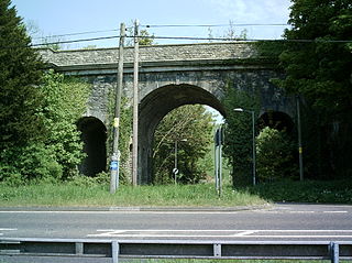
Somerton Tunnel is a railway tunnel in Somerset which is located between Somerton and Langport. It is situated on the Reading to Taunton Line. It was built by the GWR, and work finished in 1906, as part of the constructing of the Langport and Castle Cary Railway. The structure is just under a kilometre long.


