Related Research Articles
Sambaa or Shambaa or Shambala is a Bantu language of Tanzania.
The Nguru Mountains are a mountain range in Morogoro Region, Tanzania, Africa. They are part of the Eastern Arc Mountains. The mountains are predominantly covered with rainforest, home to 83 species of birds and African violets. Several forest reserves are located in the mountains.

Tanga Region is one of Tanzania's 31 administrative regions. The region covers an area of 26,667 km2 (10,296 sq mi). The region is comparable in size to the combined land area of the nation state of Burundi. The regional capital is the municipality of Tanga city. Located in northeast Tanzania, the region is bordered by Kenya and Kilimanjaro Region to the north; Manyara Region to the west; and Morogoro and Pwani Regions to the south. It has a coastline to the east with the Indian Ocean. According to the 2022 national census, the region had a population of 2,615,597.
Lushoto is one of the eleven districts of Tanga Region in Tanzania. It is bordered to the northeast by Kenya, to the east by the Muheza District, to the northwest by the Kilimanjaro Region, west by Korogwe District and to the south by the Bumbuli District. The district's capital and largest town is Lushoto.

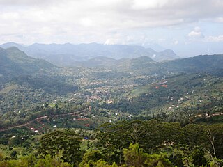
The Usambara Mountains of northeastern Tanzania in tropical East Africa, comprise the easternmost ranges of the Eastern Arc Mountains. The ranges of approximately 90 kilometres (56 mi) long and about half that wide, are situated in the Lushoto District of the Tanga Region. They were formed nearly two million years ago by faulting and uplifting, and are composed of Precambrian metamorphic rocks. They are split into two sub-ranges; the West Usambaras being higher than the East Usambaras, which are nearer the coast and receive more rainfall.
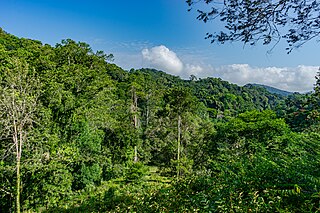
The Amani Forest Reserve, officially listed as Amani Nature Forest Reserve is a protected area located the Muheza and Korogwe Districts in the Tanga Region of Tanzania. The nature reserve was established in 1997 in order to preserve the unique flora and fauna of the East Usambara Mountains. The East and West Usambara Mountains are a biodiversity hotspot. The Amani Nature Reserve includes tropical cloud forest habitats.

The Shambaa people, also called the Sambaa, Shambala, Sambala or Sambara, are a Bantu ethnic group. Their ancestral home is on the Usambara Mountains of Lushoto District, Korogwe District and Bumbuli District. They are native to the valleys and eastern Usambara Mountains of Korogwe District, Korogwe Urban District and western Muheza District of northern Tanga Region of Tanzania. The word Shamba means "farm", and these people live in one of the most fertile Tanzanian region. Shambaai in Kisambaa means "where the banana's thrive". In 2001, the Shambaa population was estimated to number 664,000.

The Coastal forests of eastern Africa, also known as the East African Coastal Forests or Zanzibar–Inhambane forests, is a tropical moist forest region along the east coast of Africa. The region was designated a biodiversity hotspot by Conservation International.

The Umba River is located in northeastern Tanzania in Lushoto and Mkinga Districts of Tanga Region. It rises in Schageiuforest (Shagayu) in the West Usambara Mountains of Lushoto at 2,000 m altitude and flows on the north side of the mountain range to the east. At Lelwa it empties the Mbalamu River, which comes from the extreme north of the Usambara Mountains, and the Mglumi River into the Umba. Just before the Umba flows into the Indian Ocean, it crosses the border to Kenya. The mouth itself marks the most eastern point on the border between Tanzania and Kenya, which was largely made in a straight line to the northwest towards Lake Victoria in the 19th century. On the upper reaches of the river in the mid-1960s rich deposits of precious stones, including sapphires and spessartine, were discovered. Also on the river is the Umba River Game Reserve, a wildlife reserve that includes along with the Mkomazi Game Reserve, about 2,600 km2.
The Uluguru mountains are a mountain range in eastern Tanzania, named after the Luguru tribe. The main portion of the Uluguru mountains is a ridge running roughly north-south and rising to 2,630 metres (8,600 ft) altitude at its highest point. On the main Uluguru range, 50 villages touch the forest boundary and over 151,000 people are found within the mountain area, often at increasing densities at higher altitudes up to the forest boundary.

The Eastern Arc Mountains are a chain of mountains found in Kenya and Tanzania. The chain runs from northeast to southwest, with the Taita Hills being in Kenya and the other ranges being in Tanzania. They are delimited on the southwest by the fault complex represented by the Makambako Gap that separates them from the Kipengere Range. To the northeast, they are delimited by more recent volcanism represented by Mount Kilimanjaro. The chain is considered a tentative World Heritage Site.

Irente School for the Blind Girls was founded in 1963 by the Lutheran Church in the Usambara Mountains in Lushoto, Tanzania. It is a small residential/primary school. Subjects include craft training and agriculture.
The Usambara Railway was the first railway to be built in German East Africa and what is today Tanzania.
Gierra's blind snake, also commonly called the Usambara spotted blind snake and the Usambara spotted worm snake, is a species of snake in the family Typhlopidae. The species is endemic to Tanzania.

The Pangani River, is a major river of northeastern Tanzania. It has two main sources: the Ruvu, which rises as Lumi at Kilimanjaro, passes through Lake Jipe, and empties into the Nyumba ya Mungu Reservoir, and the Kikuletwa River, coming from the west and mainly fed by rivers of Mount Meru in Arusha Region, which also enters into the Nyumba ya Mungu Reservoir in Kilimanjaro Region. Just after leaving the reservoir the stream becomes the main Pangani, which empties into the Indian Ocean in Tanga Region at the Tangan port town of Pangani.

Zigi River also known as Sigi River, is a river in located in east Tanga Region in Tanzania.
The Mkuzu or Mkusu is a river of northeastern Tanzania. The Magamba Forest Reserve forms part of the landscape and there is a notable waterfall along the river named the Soni Falls, where the Mkuzu joins the Bangala River. The river also flows through the village of Kifungilo.
The Bangala is a river of northeastern Tanzania. It is a tributary of the Mkuzu River and is fed by a waterfall named the Soni Falls.
Shume is a town in Tanzania in the Usambara Mountains in Lushoto District of Tanga Region. It was formerly known as New Hornow and was the location of a sawmill during the country's colonial period. Around 1910, a cable railway was constructed to link the mill with the Usambara line to permit export to Germany.

Trioceros deremensis, the Usambara three-horned chameleon or wavy chameleon, is a species of chameleon that is endemic to forests in the Eastern Arc Mountains of Tanzania.
References
- ↑ Finke, Jens (26 November 2002). Rough guide to Tanzania. Rough Guides. p. 351. ISBN 978-1-85828-783-6 . Retrieved 31 March 2012.
4°50′48″S38°20′34″E / 4.84667°S 38.34278°E
| | This Tanga Region location article is a stub. You can help Wikipedia by expanding it. |