Sontecomapan Lagoon

Last updated
Designations
Official name Manglares y humedales de la Laguna de Sontecomapan
Designated 2 February 2004
Reference no. 1342 [1]
Laguna Sontecomapan, looking north from the Sierra de Los Tuxtlas. The Gulf of Mexico is in the distance. Laguna Sontecomapan.jpg
Laguna Sontecomapan, looking north from the Sierra de Los Tuxtlas. The Gulf of Mexico is in the distance.

Sontecomapan Lagoon (Laguna Sontecomapan also Laguna de Sontecomapan) occupies an alluvial plain in the center of the Sierra de Los Tuxtlas, 18°33′N95°1′W / 18.550°N 95.017°W / 18.550; -95.017 , in southeast central Veracruz, east central Mexico on the edge of the Gulf of Mexico. The laguna is part of the Catemaco municipio stretching from the Gulf of Mexico to the foothills of the San Martin Tuxtla Volcano and the Sierra Santa Marta.

Veracruz State of Mexico

Veracruz, formally Veracruz de Ignacio de la Llave, officially the Free and Sovereign State of Veracruz de Ignacio de la Llave, is one of the 31 states that, along with the Federal District, comprise the 32 federative entities of Mexico. It is divided in 212 municipalities and its capital city is Xalapa-Enríquez.

Mexico country in the southern portion of North America

Mexico, officially the United Mexican States, is a country in the southern portion of North America. It is bordered to the north by the United States; to the south and west by the Pacific Ocean; to the southeast by Guatemala, Belize, and the Caribbean Sea; and to the east by the Gulf of Mexico. Covering almost 2,000,000 square kilometres (770,000 sq mi), the nation is the fifth largest country in the Americas by total area and the 13th largest independent state in the world. With an estimated population of over 120 million people, the country is the eleventh most populous state and the most populous Spanish-speaking state in the world, while being the second most populous nation in Latin America after Brazil. Mexico is a federation comprising 31 states and Mexico City, a special federal entity that is also the capital city and its most populous city. Other metropolises in the state include Guadalajara, Monterrey, Puebla, Toluca, Tijuana and León.

Catemaco City and municipal seat in Veracruz, Mexico

Catemacokate'mako  is a city in Catemaco Municipality located in the south of the Mexican state of Veracruz. The city is located on Lake Catemaco, with the municipality stretching north to the Gulf of Mexico. Catemaco is a tourist destination with its main attractions being the lake, remnants of the region’s rainforest and a tradition of sorcery/witchcraft that has its roots in the pre Hispanic period and mostly practiced by men. This tradition is well known in Mexico and attracts clients from various walks of life, including businessmen and national level politicians. Catemaco holds an annual event in March dedicated to sorcery which can draw up to 5,000 visitors.

Tourism is concentrated on sightseeing the environmentally threatened mangroves of the laguna by rental lancha (boat) from the embarcadero (dock) in the village of Sontecomapan, watching kids dive at the shallow spring Poza de los Enanos and visiting the beaches of La Barra and Jicacal.

In 2004 Laguna Sontecomapan was designated as a Ramsar site. [1]

A Ramsar site is a wetland site designated to be of international importance under the Ramsar Convention.

Related Research Articles

Baja California Peninsula peninsula of North America on the Pacific Coast of Mexico

The Baja California Peninsula is a peninsula in Northwestern Mexico. It separates the Pacific Ocean from the Gulf of California. The peninsula extends 1,247 km from Mexicali, Baja California in the north to Cabo San Lucas, Baja California Sur in the south. It ranges from 40 km at its narrowest to 320 km at its widest point and has approximately 3,000 km of coastline and approximately 65 islands. The total area of the Baja California Peninsula is 143,390 km2 (55,360 sq mi).

Peninsular Ranges

The Peninsular Ranges are a group of mountain ranges that stretch 1,500 km (930 mi) from Southern California to the southern tip of the Baja California Peninsula; they are part of the North American Coast Ranges, which run along the Pacific Coast from Alaska to Mexico. Elevations range from 500 to 10,834 feet.

Laguna Catemaco lake in Mexico

Laguna Catemaco is a freshwater lake located at the center of the Sierra de Los Tuxtlas in south central Veracruz, in east central Mexico.

Los Tuxtlas

Los Tuxtlas is a region in the south of the Mexican state of Veracruz. Politically it refers to four municipalities: Catemaco, San Andrés Tuxtla, Santiago Tuxtla and Hueyapan de Ocampo. It also refers to a high complex natural ecosystem, an isolated volcanic mountain range next to the Gulf of Mexico, home to the northern edge of tropical rainforest in the Americas. Although seriously deforested, most of it is under protection as the Los Tuxtlas Biosphere Reserve, which stretches over eight municipalities, centering on the four mentioned above. The area’s early history was influenced by the Olmecs but had its own trajectory. In the colonial period, the population became a mix of indigenous, African and European. For all its history until the present, it has been rural and agricultural. Today one of its notable crops is tobacco. However, conservation efforts since the 1970s have promoted ecotourism, especially in Catemaco.

Sierra de los Tuxtlas mountain range

The Sierra de Los Tuxtlas are a volcanic belt and mountain range along the southeastern Veracruz Gulf coast in Eastern Mexico. The Los Tuxtlas Biosphere Reserve includes the coastal and higher elevations of the Sierra de Los Tuxtlas.

Montepío village in Veracruz, Mexico

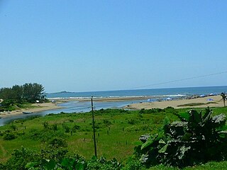
Montepío is a small village on the Gulf Coast of Mexico, within the San Andrés Tuxtla municipio, Veracruz, 1 hour away from the major tourist center of Catemaco.

Olmec heartland home of the Olmec culture in south east Mexico

The Olmec heartland is the southern portion of Mexico's Gulf Coast region between the Tuxtla mountains and the Olmec archaeological site of La Venta, extending roughly 80 km inland from the Gulf of Mexico coastline at its deepest. It is today, as it was during the height of the Olmec civilization, a tropical lowland forest environment, crossed by meandering rivers.

Laguna de los Cerros

Laguna de los Cerros is a little-excavated Olmec and Classical era archaeological site, located in the vicinity of Corral Nuevo, within the municipality of Acayucan, in the Mexican state of Veracruz, in the southern foothills of the Tuxtla Mountains, some 30 kilometres (19 mi) south of the Laguna Catemaco.

La Mojarra archaeological site in Mexico

La Mojarra is an archaeological site in the Mexican state of Veracruz, located not far from the Gulf Coast at a bend in the Acula River. It was continually occupied from the late Formative period until perhaps as late as 1000 CE.

Los Flamencos National Reserve

Los Flamencos National Reserve is a nature reserve located in the commune of San Pedro de Atacama, Antofagasta Region of northern Chile. The reserve covers a total area of 740 square kilometres or 73,986 hectares in the Central Andean dry puna ecoregion and consists of seven separate sections.

Matacapan

Matacapan or Matacapan Piedra is a Classic era archaeological site in present-day Mexican state of Veracruz situated in the Sierra de Los Tuxtlas, near Catemaco.

The Central America bioregion is a biogeographic region comprising southern Mexico and Central America.

Catemaco (municipality) Municipality in Veracruz, Mexico

Catemaco Municipality is one of the 212 municipalities that make up the Mexican state of Veracruz. It is located in the state's Los Tuxtlas. The municipal seat is the city of Catemaco.

San Andrés Tuxtla City and municipality in Veracruz, Mexico

San Andrés Tuxtla is a city and municipality in the south of the Mexican state of Veracruz. The city is the largest in the Los Tuxtlas region. It was founded after an eruption of the San Martín Volcano pushed people into this valley during the early colonial period. Since the 19th century, the area has been the center of Mexico’s production of fine tobacco, mostly used in the making of cigars. The best known cigar producer here, Te Amo, is considered to be one of the best brands in the world.

Lerdo de Tejada Municipality in Veracruz, Mexico

Lerdo de Tejada is a municipality in the Mexican state of Veracruz, located 207 kilometres (129 mi) southeast of the state capital Xalapa. It is named after Sebastián Lerdo de Tejada, the 27th President of Mexico.

Isla Municipality is a municipality in Veracruz, Mexico. It is located in south zone of the State of Veracruz, about 370 km from state capital Xalapa. It has a surface of 714.80 km2. It is located at 18°02′N95°32′W.

Soteapan is a municipality and city located in the south-east zone in the State of Veracruz, about 260 km from state capital Xalapa. It has a surface of 528.07 km2. It is located at 18°14′N94°52′W.

Eyipantla Falls

Eyipantla Falls is a waterfall located in the Los Tuxtlas region of southern Veracruz in Mexico. It is forty meters wide and fifty meters tall and is the largest and most important waterfall in the region.

References

  1. 1 2 "Manglares y humedales de la Laguna de Sontecomapan". Ramsar Sites Information Service. Retrieved 25 April 2018.

Coordinates: 18°32′N95°00′W / 18.533°N 95.000°W / 18.533; -95.000

Geographic coordinate system Coordinate system

A geographic coordinate system is a coordinate system that enables every location on Earth to be specified by a set of numbers, letters or symbols. The coordinates are often chosen such that one of the numbers represents a vertical position and two or three of the numbers represent a horizontal position; alternatively, a geographic position may be expressed in a combined three-dimensional Cartesian vector. A common choice of coordinates is latitude, longitude and elevation. To specify a location on a plane requires a map projection.