
Burgenland is the easternmost and least populous state of Austria. It consists of two statutory cities and seven rural districts, with a total of 171 municipalities. It is 166 km (103 mi) long from north to south but much narrower from west to east. The region is part of the Centrope Project.

Sopron is a city in Hungary on the Austrian border, near Lake Neusiedl/Lake Fertő.

The Treaty of Trianon was prepared at the Paris Peace Conference and was signed in the Grand Trianon château in Versailles on 4 June 1920. It formally ended World War I between most of the Allies of World War I and the Kingdom of Hungary. French diplomats played the major role in designing the treaty, with a mind to establishing a French-led coalition of the newly formed states. It regulated the status of the Kingdom of Hungary and defined its borders generally within the ceasefire lines established in November–December 1918 and left Hungary as a landlocked state that included 93,073 square kilometres (35,936 sq mi), 28% of the 325,411 square kilometres (125,642 sq mi) that had constituted the pre-war Kingdom of Hungary. The truncated Kingdom had a population of 7.6 million, 36% compared to the pre-war kingdom's population of 20.9 million. In the last census before the Treaty of Trianon held in 1910, which recorded population by language and religion, but not by ethnicity, speakers of the Hungarian language included approximately 48% of the entire population of the Kingdom of Hungary. Though the areas that were allocated to neighbouring countries had a majority of non-Hungarians, in them lived 3.3 million Hungarians – 31% – who were now in a minority status. The treaty limited Hungary's army to 35,000 officers and men, and the Austro-Hungarian Navy ceased to exist. These decisions and their consequences have been the cause of deep resentment in Hungary ever since.

The Treaty of Saint-Germain-en-Laye was signed on 10 September 1919 by the victorious Allies of World War I on the one hand and by the Republic of German-Austria on the other. Like the Treaty of Trianon with Hungary and the Treaty of Versailles with Germany, it contained the Covenant of the League of Nations and as a result was not ratified by the United States but was followed by the US–Austrian Peace Treaty of 1921.

The Carinthian plebiscite was held on 10 October 1920 in the area predominantly settled by Carinthian Slovenes. It determined the final southern border between the Republic of Austria and the newly formed Kingdom of Serbs, Croats and Slovenes (Yugoslavia) after World War I.
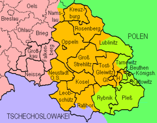
The Upper Silesia plebiscite was a plebiscite mandated by the Versailles Treaty and carried out on 20 March 1921 to determine ownership of the province of Upper Silesia between Weimar Germany and Poland. The region was ethnically mixed with both Germans and Poles; according to prewar statistics, ethnic Poles formed 60 percent of the population. Under the previous rule by the German Empire, Poles claimed they had faced discrimination, making them effectively second class citizens. The period of the plebiscite campaign and inter-Allied occupation was marked by violence. There were three Polish uprisings, and German volunteer paramilitary units came to the region as well.
Győr-Moson-Sopron is an administrative county in north-western Hungary, on the border with Slovakia and Austria (Burgenland). It shares borders with the Hungarian counties Komárom-Esztergom, Veszprém and Vas. The capital of Győr-Moson-Sopron county is Győr. The county is a part of the Centrope Project.

Lake Neusiedl, or Fertő is the largest endorheic lake in Central Europe, straddling the Austrian–Hungarian border. The lake covers 315 km2 (122 sq mi), of which 240 km2 (93 sq mi) is on the Austrian side and 75 km2 (29 sq mi) on the Hungarian side. The lake's drainage basin has an area of about 1,120 km2 (430 sq mi). From north to south, the lake is about 36 km (22 mi) long, and it is between 6 km and 12 km wide from east to west. On average, the lake's surface is 115.45 m (378.8 ft) above the Adriatic Sea and the lake is no more than 1.8 m deep.

Lajtabánság, or the Banate of Leitha, was a short-lived western Hungarian state in the region where the Austrian federal state of Burgenland now exists. It existed between October 4 and November 10, 1921, following the Treaty of Trianon and the departure of the rump Kingdom of Hungary's army and after the Sopron plebiscite was held in the area according to the Venice protocol.

The "Rongyos Gárda" were a non-regular paramilitary unit in Hungary, active in 1921 then reestablished in 1938.

The Republic of German-Austria was a country created following World War I as the initial rump state for areas with a predominantly German-speaking and ethnic German population within what had been the Austro-Hungarian Empire. The territories covered an area of 118,311 km2 (45,680 sq mi), with 10.4 million inhabitants. In practice, however, its authority was limited to the Danubian and Alpine provinces which had been the core of the Austrian Empire.
The presence of German-speaking populations in Central and Eastern Europe is rooted in centuries of history, with the settling in northeastern Europe of Germanic peoples predating even the founding of the Roman Empire. The presence of independent German states in the region, and later the German Empire as well as other multi-ethnic countries with German-speaking minorities, such as Hungary, Poland, Imperial Russia, etc., demonstrates the extent and duration of German-speaking settlements.
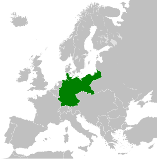
The territorial changes of Germany include all changes in the borders and territory of Germany from its formation in 1871 to the present. Modern Germany was formed in 1871 when Otto von Bismarck unified most of the German states, with the notable exception of Austria, into the German Empire. After the First World War, Germany lost about 10% of its territory to its neighbours and the Weimar Republic was formed. This republic included territories to the east of today's German borders.

Kolindros is a town and a former municipality in Pieria regional unit, in Central Macedonia, Greece. Since the 2011 local government reform it has been part of the municipality Pydna-Kolindros, of which it is a municipal unit. The municipal unit has an area of 124.639 km2, the community 47.856 km2. In 2011, the municipal unit had a population of 3,883 residents. The community of Kolindros, consisting of the settlement of Kolindros and that of Paliampela, has a population of 3,032 residents.

The Anschluss, also known as the Anschluss Österreichs, was the annexation of the Federal State of Austria into the German Reich on 13 March 1938.
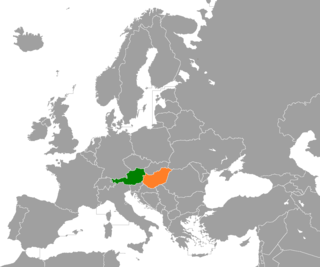
Neighbourly relations exist between Austria and Hungary, two member states of the European Union. Both countries have a long common history since the ruling dynasty of Austria, the Habsburgs, inherited the Hungarian throne in the 16th century. Both were part of the now-defunct Austro-Hungarian Empire from 1867 to 1918. The two countries established diplomatic relations in 1921, after their separation.
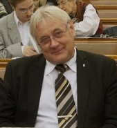
Mátyás Firtl is a Hungarian engineer and politician, who was elected member of the National Assembly (MP) for Sopron during a by-election in 2005, holding the seat until 2018.

The Raaberbahn or GySEV is a Hungarian-Austrian railway company based in Sopron, Hungary. The company is a joint enterprise of the states of Hungary (65.6%), Austria (28.2%) and a holding belonging to ÖBB Austrian Federal Railways (4.9%). In Hungary it is called Győr-Sopron-Ebenfurti Vasút (GySEV), in German it was called Raab-Oedenburg-Ebenfurther Eisenbahn (ROeEE) until 2008 when it changed to its name to Raaberbahn.

Sopron is a district in western part of Győr-Moson-Sopron County. Sopron is also the name of the town where the district seat is found. The district is located in the Western Transdanubia Statistical Region.
Sopronbánfalva, also known as Bánfalva, is a former village part of the city of Sopron, Hungary, since 1950. Before 1945, the village had 3,304 inhabitants, with the majority being ethnic Germans. However, many were deported, remaining only approximately 700 inhabitants after the event. This happened due to the desire to, among other things, secure the border with Austria.
