Related Research Articles

Grosvenor Bridge, originally known as, and alternatively called Victoria Railway Bridge, is a railway bridge over the River Thames in London, between Vauxhall Bridge and Chelsea Bridge. Originally constructed in 1860, and widened in 1865 and 1907, the bridge was extensively rebuilt and widened again in the 1960s as an array of ten parallel bridges.

Ballinhassig is a village in County Cork, Ireland, situated 10.6 km south of Cork City just off the N71 Bandon road and near the source of the River Owenabue.
Villanúa is a Pyrenean municipality in Spain in the north of Huesca province, in la Jacetania, set where the Aragon valley gets wider. Its name refers to the "new village" repopulated in the late 10th century. Villanúa's altitude is 953 m and it covers 58.2 km2. The village is at the bottom of mount Collarada and in 2018 had 447 inhabitants.

Fria is a town and Sub-prefecture in Lower Guinea, lying north of Conakry near the Amaria Dam on the Konkouré River. As of 2014 it had a population of 61,691 people.

Unorganized North Algoma District is an unorganized area in northeastern Ontario, Canada, comprising all areas in Algoma District, north of the Sault Ste. Marie to Elliot Lake corridor, which are not part of an incorporated municipality or a First Nation. It covers 44,077.03 km2 (17,018.24 sq mi) of land, and had a population of 5739 in 2016.

Sandbach railway station serves the town of Sandbach in Cheshire, England. The station is 4¾ miles (8 km) north east of Crewe on the Crewe to Manchester Line.

Upper Ballinderry is a small village to the east of Lower Ballinderry in County Antrim, Northern Ireland. It is within the townland and civil parish of Ballinderry, the historic barony of Massereene Upper. and the Lisburn City Council area. Upper Ballinderry is about 10 miles north- west of Lisburn. In the 2001 Census it had a population of 192 people.

Lunsar is a town in Port Loko District in the Northern Province of Sierra Leone. It is the largest town in Port Loko District by population. The Britannica estimate of the population of Lunsar is 36,108. The town is one of the main commercial and business hub in the North of Sierra Leone. Lunsar lies approximately 50 miles east of Freetown and about 18 miles south-east of the district capital of Port Loko. The inhabitants of Lunsar are largely from the Temne ethnic group.
Masala is a village of 5,855 inhabitants in Kirkkonummi municipality. It is located in the western Uusimaa region, in southern Finland, just outside the Helsinki Metropolitan Area. Masala railway station, a station on the Helsinki commuter rail network is located in Masala. The Finnish Geodetic Institute also is located there.
Cisséla is a town and sub-prefecture in the Kouroussa Prefecture, Kankan Region, of eastern-central Guinea. As of 2014 it had a population of 41,562 people.

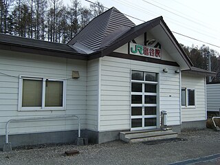
Shirataki Station is a railway station on the Sekihoku Main Line in Engaru, Monbetsu District, Hokkaido, Japan, operated by Hokkaido Railway Company.
Blackpool Pleasure Beach Express is a 21 in narrow gauge railway, built in 1933 as a tourist attraction at Pleasure Beach Blackpool, Lancashire.
Gnaléah is a town and sub-prefecture in the Faranah Prefecture in the Faranah Region of Guinea. As of 2014 it had a population of 15,221 people.
Moussaya is a town and sub-prefecture in the Forécariah Prefecture in the Kindia Region of western Guinea.
Kolenté is a town and sub-prefecture in the Kindia Prefecture in the Kindia Region of western Guinea.
Souguéta is a town and sub-prefecture in the Kindia Prefecture in the Kindia Region of western Guinea.
Gadha-Woundou is a town and sub-prefecture in the Koubia Prefecture in the Labé Region of northern Guinea.
Saréboido is a town and sub-prefecture in the Koundara Prefecture in the Boké Region of northern Guinea. As of 2014 it had a population of 33,700 people.
Djountou is a town and sub-prefecture in the Lélouma Prefecture in the Labé Region of northern-central Guinea.
Shioya Station is a railway station on the Hakodate Main Line in Otaru, Hokkaido, Japan, operated by Hokkaido Railway Company. The station is numbered S16.
References
Coordinates: 10°09′N12°32′W / 10.150°N 12.533°W

A geographic coordinate system is a coordinate system that enables every location on Earth to be specified by a set of numbers, letters or symbols. The coordinates are often chosen such that one of the numbers represents a vertical position and two or three of the numbers represent a horizontal position; alternatively, a geographic position may be expressed in a combined three-dimensional Cartesian vector. A common choice of coordinates is latitude, longitude and elevation. To specify a location on a plane requires a map projection.
| This Guinea location article is a stub. You can help Wikipedia by expanding it. |