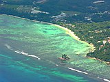
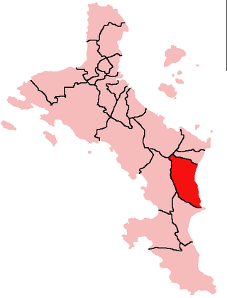
Takamaka is one of the 26 administrative regions of Mahé, Republic of Seychelles. It is located on the southern part of the island of Mahé. Three other districts cover the two other main islands of the Republic, Grand' Anse and Baie Sainte Anne on the island of Praslin and the inner islands district which comprise the 3rd largest island, La Digue. The population of Takamata is estimated at around 3,000.

Mahé is the largest island of Seychelles, with an area of 157.3 square kilometres (60.7 sq mi), lying in the northeast of the Seychellois nation in the Somali Sea part of the Indian Ocean. The population of Mahé was 77,000, as of the 2010 census. It contains the capital city of Victoria and accommodates 86% of the country's total population. The island was named after Bertrand-François Mahé de La Bourdonnais, a French governor of Isle de France.

Praslin is the second largest island (38.5 km2) of the Inner Seychelles, lying 44 km (27 mi) northeast of Mahé. Praslin has a population of around 7,533 people and comprises two administrative districts: Baie Sainte Anne and Grand' Anse. The main settlements are the Baie Ste Anne, Anse Volbert and Grand' Anse.

Anse Boileau is an administrative district on the south of the island of Mahé in the Seychelles. Anse Boileau encapsulates the natural wonders of the Seychelles: it sits at the foot of a steep, green mountain, it is on the shores of the Indian Ocean, and in its midst are streams, mini-forests, creeks, ponds, and an enchanting array of all that defines the Seychellois landscape. It is often described as a fishing village because many of the local residents fish for a living. It has a school, a restaurant, a number of grocery shops, a health centre, and a police station. It is a short distance away from Anse La Mouche, a popular tourist destination. Anse Boileau is so-called because of its many coves.

Grand'Anse Mahé is an administrative district of Seychelles located on the island of Mahé.

Anse aux Pins is an administrative district of Seychelles located on the island of Mahé. Soleil Island is part of the district.

Anse Etoile is an administrative district of Seychelles on the island of Mahé.
Au Cap is an administrative district of Seychelles located on the island of Mahé.

Anse Royale is an administrative district of Seychelles located on the island of Mahé. The Seychelles Polytechnic School of the Humanities is located in this district.
Sainte Anne Island is the largest (2.27 km²) of eight islands in Ste Anne Marine National Park of the Seychelles. These islands are part of the Mont Fleuri District of the Seychelles. It is 4 km off the east coast of Mahé and has abundant tropical vegetation. The highest peak on Sainte Anne is 246 meters.

The Granitic Seychelles are the islands in Seychelles which lie in central position on the Seychelles Bank and are composed of granite rock. They make up the majority of the Inner Islands, which in addition include the coral islands along of the rim of the Seychelles Bank, namely Bird Island and Denis Island. The Granitic Seychelles contrast with the Coralline Seychelles or the Outer Islands, several island groups made up of low coral islands with dry, infertile soils.

Tourism is the most important nongovernment sector of Seychelles' economy. About 15 percent of the formal work force is directly employed in tourism, and employment in construction, banking, transportation, and other activities is closely tied to the tourist industry. Tourists enjoy the Seychelles' coral beaches and opportunities for water sports. Wildlife in the archipelago is also a major attraction.
Articles related to Seychelles include:

The Mahé highlands and surrounding areas Important Bird Area occupy the central and north-western part of the island of Mahé in the Seychelles archipelago of the western Indian Ocean.
Round is an island in Seychelles, lying less than a mile southeast of the island of Praslin tilted a little to the southeast of Praslin's easternmost Peninsula and 48 km north-east of the island of Mahe
Chauve Souris is an island in Seychelles, lying 400 m northeast of the island of Praslin. Another nearby island - Saint-Pierre Island is located immediately in the north. The island is a granite island covered with tropical forest. Fauna is limited to the likes of skinks, geckos and limited birdlife that chiefly use the island as a roost.
Ile Soleil is a small artificial island (0.14 km²) in the Seychelles, lying 50m off the east coast of Mahé, near the runway of the Seychelles International Airport.
Chauve Souris is an island in Seychelles, lying 400 m west of Anse La Mouche on the island of Mahé. The island is a rocky granite island covered with tropical forest. There is also a Chauve Souris island near the northern coast of the island of Praslin.
L'Islette Island is an island in Seychelles, located 120 meters from the eastern coast of the island of Mahe, in the bay of Port Glaud. It is also near Thérèse Island which lies to its southwest and Petite Island which lies to its east. L'Islette Island is a granite island densely covered with tropical vegetation.

The Seychelles Postal Service, is the public operator responsible for postal service in Seychelles.