Related Research Articles

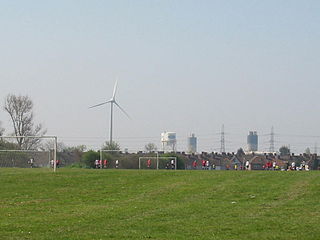
Becontree or is an area of approximately 4 square miles (10 km2) in the London Borough of Barking and Dagenham. It is located 11 miles (17.7 km) east-northeast of Charing Cross and was constructed in the interwar period as the largest public housing estate in the world. The Housing Act 1919 permitted the London County Council to build housing outside the County of London and Becontree was constructed between 1921 and 1935 to cottage estate principles in the parishes of Barking, Dagenham and Ilford, then in the administrative and ceremonial county of Essex. The official completion of the estate was celebrated in 1935, by which time the estate had a population of around 100,000 people in 26,000 homes.

The London Borough of Barking and Dagenham is a London borough in East London. It lies around 9 miles (14.4 km) east of Central London. It is an Outer London borough and the south is within the London Riverside section of the Thames Gateway; an area designated as a national priority for urban regeneration. At the 2011 census it had a population of 187,000, the majority of which are within the Becontree estate. The borough's three main towns are Barking, Chadwell Heath and Dagenham. The local authority is the Barking and Dagenham London Borough Council. Barking and Dagenham was one of six London boroughs to host the 2012 Summer Olympics.
Dagenham is a town in East London, England, within the London Borough of Barking and Dagenham. Dagenham is centred 11.5 miles (18.5 km) east of Charing Cross.

Barking is a town in East London, England, within the London Borough of Barking and Dagenham. It is 9.3 miles (15 km) east of Charing Cross. The total population of Barking was 59,068 at the 2011 census. In addition to an extensive and fairly low-density residential area, the town centre forms a large retail and commercial district, currently a focus for regeneration. The former industrial lands to the south are being redeveloped as Barking Riverside.

London South Bank University (LSBU) is a public university in Elephant and Castle, London. It is based in the London Borough of Southwark, near the South Bank of the River Thames, from which it takes its name. Founded in 1892 as the Borough Polytechnic Institute, it achieved university status in 1992 under the Further and Higher Education Act 1992.

University of East London (UEL) is a public university located in the London Borough of Newham, London, England, based at three campuses in Stratford and Docklands, following the opening of University Square Stratford in September 2013. The University of East London began as the West Ham Technical Institute and it was officially opened in October 1898 after approval was given for the construction of the site by the West Ham Technical Instruction Act Committee in 1892 following the Technical Instruction Act of 1889. It gained university status in 1992. It was formerly known as College of East London.

Coventry University is a public research university in Coventry, England. The origins of Coventry University can be linked to the founding of the Coventry School of Design in 1843. It was known as Lanchester Polytechnic from 1970 until 1987, and then as Coventry Polytechnic until the Further and Higher Education Act 1992 afforded its university status that year and the name was changed to Coventry University.

East London is the northeastern part of London, England, east of the ancient City of London and north of the River Thames as it begins to widen. East London developed as London's docklands and the primary industrial centre. The expansion of railways in the 19th century encouraged the eastward expansion of the East End of London and a proliferation of new suburbs. The industrial lands of East London are today an area of regeneration, which are well advanced in places such as Canary Wharf and ongoing elsewhere.

Waterlow Park is a 26-acre (11 ha) park in the south east of Highgate Village, in north London. It was given to the public by Sir Sydney Waterlow, as "a garden for the gardenless" in 1889.

The London Riverside is a redevelopment area on the north side of the River Thames in East London, England. The area was identified as a zone of change following the introduction of the Thames Gateway policy in 1995. Proposals for improvements in the area were at first developed by Havering and Barking and Dagenham councils, with a London Riverside Urban Strategy published in 2002. This was incorporated into the first London Plan published by the Mayor of London in 2004. Between 2004 and 2013 the planning powers in London Riverside and the Lower Lea Valley were the responsibility of the London Thames Gateway Development Corporation. Planning powers have now reverted to the local councils. Much of the land available for redevelopment is now owned by GLA Land and Property. There is also a London Riverside business improvement district, which covers a smaller area.

Thames Chase is a community forest of 9842 hectares located in 47 sites in London and Essex, England. Its stated aim is "to renew and regenerate the landscape at the edge of East London and South Essex by creating Thames Chase, the Community Forest: a varied wooded landscape for local people to influence, create, use, enjoy and cherish".

Barking was a local government district, and later civil parish and borough, in southwest Essex, England from 1882 to 1965. It was known as Barking Town from 1882 to 1931. The district included the town of Barking, eastern Beckton and the southwestern part of the Becontree estate. The district was within the Metropolitan Police District and experienced a steady increase in population during its existence. It now forms the western part of the London Borough of Barking and Dagenham and the eastern extremity of the London Borough of Newham in Greater London.
Dagenham was a local government district in south west Essex, England from 1926 to 1965 covering the parish of Dagenham. Initially created as an urban district, it was incorporated as a municipal borough in 1938. It was established to deal with the increase in population and the change from rural to urban area caused by the building of the Becontree estate by the London County Council and the subsequent movement of people from Inner London. Peripheral to London, the district formed part of the Metropolitan Police District and London Traffic Area. It now forms the eastern sections of the London Borough of Barking and Dagenham and the London Borough of Redbridge in Greater London.
Ilford was a civil parish and local government district in south west Essex, England from 1888 to 1965, covering the town Ilford. The district saw a considerable rise in population throughout its life, caused by the expansion of the built-up area of London, and became one of the most populous districts of its type in England. The district now corresponds to the greater part of the London Borough of Redbridge in Greater London.
Becontree Heath is an open space in the London Borough of Barking and Dagenham. The name has also been applied to the local area, in particular to the RM8 postal district.

Barking Riverside is a mixed-use development in the area of Barking, east London, England, within the London Borough of Barking and Dagenham. It is being built on land formerly occupied by Barking Power Station, adjacent to the River Thames, and is 10.5 miles (16.9km) east of Charing Cross. The 440 acre brownfield site has planning permission for 10,800 homes.
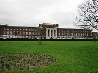
The Civic Centre in Dagenham is a former municipal building in Becontree Heath, an area within the London Borough of Barking and Dagenham. The building was designed in the modern style by the British architect Ernest Berry Webber in 1936 and was opened the following year. The local authority, Barking and Dagenham London Borough Council, occupied the building until 2016 when it was vacated and leased to CU London, a new university, the following year. It was designated as a Grade II listed building in 1981.
The Sydney Russell School is a coeducational secondary school and sixth form located in Dagenham, London, England.

The University of East London Stratford Campus is based in and around University House, a Grade II* listed building, located in Stratford, London in the London Borough of Newham. The nearest station is Maryland.
CU London is a Higher Education institute owned and governed by Coventry University. CU London began offering courses to students in September 2017. It currently operates out of two sites, one in the former Dagenham Civic Centre in the London Borough of Barking and Dagenham and another in the Mitre Passage building in the Greenwich Peninsula. It includes Coventry University's second and third campuses in the capital alongside Coventry University London.
References
- ↑ "London: Educational Establishments: South-East Essex Technical College and School of Art (1945–1958)". Arts & Humanities Research Council, UK. Retrieved 22 April 2011.
- 1 2 3 4 5 "Local Studies Information Sheet No.3 THE UNIVERSITY OF EAST LONDON (UEL)BARKING CAMPUS" (PDF). London Borough of Barking and Dagenham. Archived from the original (PDF) on 5 April 2012.
- 1 2 Hibbert, Christopher; Weinreb, Ben; Keay, John; Keay, Julia; Weinreb, Matthew (2009), The London Encyclopedia (3 ed.), Pan Macmillan, p. 42, ISBN 978-1-4050-4925-2
- ↑ "South East Essex Technical College – Archives hub". Archives Hub. University of East London Archives. 1936–1970. Retrieved 24 August 2021.
- 1 2 3 "The History of the Borough Group". Cliff Holden. November 2004. Retrieved 20 April 2011.