Related Research Articles
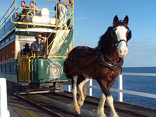
The Victor Harbor Horse Drawn Tram is located on the shores of the city of Victor Harbor, South Australia, Australia. A 3.1 km (1.9 mi) tramway links the city's visitor information centre with the nearby Granite Island. Much of its route is over a 630-metre (2,070-foot) causeway.

Oaklands railway station is located on the Seaford railway line in Adelaide, South Australia. It is in the south-western suburb of Oaklands Park, 13 kilometres from Adelaide station.

The City of Mitcham is a local government area in the foothills of southern Adelaide, South Australia. Within its bounds is Flinders University, South Australia's third largest, and the notable, affluent suburb of Springfield which contains some of the city's most expensive properties.

The Seaford line is a suburban commuter line in Adelaide, South Australia.

Northfield is a suburb of the greater Adelaide, South Australia area.
Regency Park is an inner-northern suburb of Adelaide, 6 km from the City Centre, in the state of South Australia, Australia. It is located in the City of Port Adelaide Enfield, and is adjacent to Wingfield, Angle Park, Ferryden Park, Kilburn, Prospect, Dudley Park and Croydon Park. It is bounded to the north by Grand Junction Road, east by the Gawler railway line, south by Regency Road and to the west by Days and South Roads. The postcode for Regency Park is 5010.

Christie Downs railway station is located on the Seaford line. Situated in the southern Adelaide suburb of Christie Downs, it is 28.9 kilometres from Adelaide station.

Islington railway station is located on the Gawler line. Situated in the inner northern Adelaide suburb of Prospect adjacent to Regency Road, it is 6 kilometres (3.7 mi) from the Adelaide station.
Bowmans is a locality in South Australia's Mid North. At the 2006 census, Bowmans had a population of 203. It is named after R and C Bowman who were "pastoralists in area."
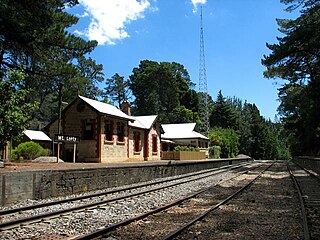
Mount Lofty Railway Station is located on the Adelaide-Wolseley line and served the Adelaide Hills suburb of Stirling. It is located 19+1⁄4 miles (31.0 km) from Adelaide station.

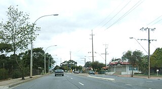
Tapleys Hill Road is a north–south arterial road which runs parallel to the coast through western Adelaide, Australia. This name covers many consecutive streets and is not widely known to most drivers except for the northernmost section, as the entire allocation is still best known as by the names of its constituent parts: Tapleys Hill Road proper, Brighton Road, Ocean Boulevard, Lonsdale Road, Dyson Road, Murray Road, and Gawler Street. This article will deal with the entire length of the corridor for sake of completion, as well to avoid confusion between declarations.
Pooraka railway station was located approximately 12.9 km by rail from Adelaide on the former 3.9 kilometres (2.4 mi) long Northfield branch line that opened in June 1857. The station opened as Abattoirs railway station on 12 July 1913, when the adjacent Gepps Cross Abattoirs also opened. The station's livestock sidings extended for most of the 970 metres of the line between Port Wakefield Road and the Gawler Road.

Aldgate railway station was located on the Adelaide-Wolseley line in the Adelaide Hills suburb of Aldgate, 34.9 kilometres from Adelaide station.
Ambleside railway station was located about 43.5 kilometres from Adelaide station, on the Adelaide-Wolseley line, in the Adelaide Hills suburb of Balhannah, at an elevation of 318 metres.
Northfield railway station was located 14.3 km (9 mi) from Adelaide station.

Seaford Meadows railway station is located on the Seaford line in South Australia. Situated in the southern Adelaide suburb of Seaford Meadows, it is 34.7 kilometres from Adelaide station.
The Milang railway line was a branch line, now closed, of the former South Australian Railways that left the mainline to Victor Harbor at the farming locality of Sandergrove, 9 km (6 mi) south of Strathalbyn and 89.7 km (55.75 mi) by rail from Adelaide. From there it proceeded in a south-easterly direction for 13.1 km (8.1 mi) to the riverport of Milang on Lake Alexandrina, in the estuary of the River Murray. The line was opened on 17 December 1884; it was formally closed on 17 June 1970. The route is now a "rail trail" that is popular with hikers. The precincts of the former Milang station house a railway museum that includes an innovative locomotive driving simulator for visitors to operate. Onsite is a centre for South Australian historical light railways.
Cavan railway station was located 12.1 kilometres (7.5 mi) by rail from Adelaide on the now closed Northfield branch line. Its elevation was 13 metres (43 ft) above sea level.
References
Thompson MH. "The Goodwood - Brighton - Willunga line." ARHS bulletin, 336, October, 1965.
35°01′30″S138°31′15″E / 35.02497°S 138.5209°E
| | This article about Adelaide is a stub. You can help Wikipedia by expanding it. |
| | This article about a railway station in South Australia is a stub. You can help Wikipedia by expanding it. |