Related Research Articles

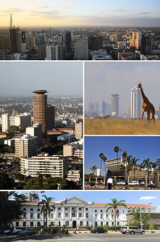
Nairobi is the capital and largest city of Kenya. The name is derived from the Maasai phrase Enkare Nairobi, which translates to 'place of cool waters', a reference to the Nairobi River which flows through the city. The city proper had a population of 4,397,073 in the 2019 census.

Mombasa is a coastal city in southeastern Kenya along the Indian Ocean. It was the first capital of British East Africa, before Nairobi was elevated to capital status in 1907. It now serves as the capital of Mombasa County. The town is known as "the white and blue city" in Kenya. It is the country's oldest and second-largest city after Nairobi, with a population of about 1,208,333 people according to the 2019 census.

The United Nations Institute for Training and Research (UNITAR) is a dedicated training arm of the United Nations system. UNITAR provides training and capacity development activities to assist mainly developing countries with special attention to Least Developed Countries (LDCs), Small Island Developing States (SIDS) and other groups and communities who are most vulnerable, including those in conflict situations.

Kericho is the largest town in Kericho County, located in the highlands west of the Kenyan Rift Valley. Positioned on the edge of the Mau Forest, Kericho benefits from a warm and temperate climate, making it good for agriculture, especially large scale tea cultivation.
Education in Kenya refers to the institutionalised education system in Kenya, whereby pupils and students are taught in specific locations, following a particular curriculum. The institutionalised system differs from traditional education which had been in existence long before missionarisation and colonisation, and was administered according to the various indigenous groups' cultures and customs.
Lang'ata is a predominantly upper middle-class residential suburb of Nairobi in Kenya. The suburb consists of many smaller housing developments, referred to as estates. They include Nairobi Dam, Otiende, Southlands, Ngei, Jambo estate, Onyonka, Madaraka Estate, Kutch Prant, Rubia, NHC Langata, Akiba, Sun Valley, Royal Park and many others. These developments are primarily maisonettes or apartment blocks.
Kenya Revenue Authority (KRA) is an agency of the Government of Kenya that is responsible for the assessment, collection and accounting of all revenues that are due to the government in accordance with the laws of Kenya.

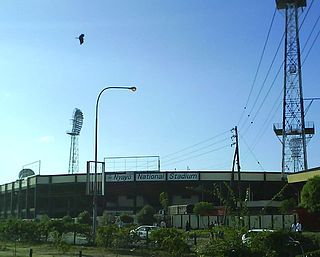
Nyayo National Stadium is a 18,000-seater multi-purpose stadium in Nairobi, Kenya. It is located at the square of Mombasa Road, Langata Road, and the Aerodrome Road. It is approximately two kilometers from the City Center, directly opposite Nairobi Mega Mall, formerly known as Nakumatt Mega. It is currently mostly used for football matches hosting AFC Leopards football club. Rugby union club Mwamba RFC used to use the stadium for home games. The stadium is also used for athletics, swimming, and various ceremonies, most common of which are National Holiday celebrations. Other facilities at the stadium include a gymnasium and a 50-metre swimming pool. The stadium houses the headquarters for the Football Kenya Federation and Athletics Kenya.

Gilgil, Kenya, is a town in Nakuru County, Kenya. The town is located between Naivasha and Nakuru and along the Nairobi - Nakuru highway. It is to the west of the Gilgil River, which flows south to feed Lake Naivasha.
Parklands is a neighbourhood in the city of Nairobi, the capital and largest city in Kenya. It is divided into numbered avenues. The name arises from the proximity of the area to City Park, Nairobi.

Kenya's National Police Service (NPS) is the umbrella law enforcement organ in Kenya. The service was established in 2011 under Article 243 of the Constitution of Kenya, following dissolution of Kenya Police Force and Administration Police Force.
South B is the name of a Division of the sub-county of Starehe in Nairobi, Kenya and the name of a "sub-location" of Mukuru Nyayo within the Division. The 2019 Kenya Census gives a population of 102,441 for South B Division and 34,216 for the sub-location. South B is about 3 kilometres (1.9 mi) south-east of Nairobi Central Business District; the Industrial Area lies to the east and the South C district to the south-west.

Chase Bank Kenya Limited(CBK), commonly referred to as Chase Bank, was a commercial bank in Kenya, licensed by the Central Bank of Kenya, the central bank and national banking regulator.

Upper Hill is a neighbourhood of the city of Nairobi, the capital and largest city of Kenya. The district has seen an increase in major construction in recent years, with several multinational corporations setting up offices.

Kasarani is a mixed-use neighbourhood in northeast Nairobi. Kasarani is also used in reference to the city's second most populated sub-county with the same name, encompasing various neighbourhoods in the northeastern areas of Nairobi. Located within the larger Kasarani area, the Kasarani enclave is approximately 11 kilometres (7 mi) northeast of Nairobi's central business district off Thika Road.

Karura Forest is an urban forest in Nairobi, the capital of Kenya. The forest was gazetted in 1932 and is managed by the Kenya Forest Service in conjunction with the Friends of Karura Forest Community Forest Association.
The following is a timeline of the history of the city of Nairobi, Kenya.

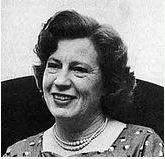
Eugenie Dorothy Hughes, was a Kenyan architect, politician, social reformer and disability activist. She founded the Kenyan Council of Social Services and served as the head of the Sports Association for the Disabled. As the first East African female architect, she owned her own firm and is best known for her design of the Cathedral of the Holy Family in Nairobi.
Ngara is a commercial and residential suburb of Nairobi. Located within the larger Starehe Sub-county, it is approximately 1.7 kilometres (1.1 mi) northeast of Nairobi's central business district along Muranga Road.
References
- ↑ Daily Nation, August 16, 2009: Odumbe back in action after ban
- ↑ Matiko, Sinda (March 16, 2023). "South C's finest: Remembering E-Sir 20 years on". Nation. Retrieved June 12, 2023.