South Carolina Highway 402

Last updated

South Carolina 402.svg

South Carolina Highway 402
SC 402 map.svg
Route information
Maintained by SCDOT
Length 15.68 mi [1] (25.23 km)
Existed 1952 – present
Major junctions
West endNo image wide.svgAlt plate.svg
US 52.svgUS 17.svg To US 52 / US 17 Alt. near Moncks Corner
East endSouth Carolina 41.svg SC 41 in Huger
Location
Counties Berkeley
Highway system
US 401.svg US 401 SC 403 South Carolina 403.svg

South Carolina Highway 402 (SC 402) is a primary state highway in the U.S. state of South Carolina. It serves to connect the community of Cordesville with the surrounding highways.

A state highway, state road, or state route is usually a road that is either numbered or maintained by a sub-national state or province. A road numbered by a state or province falls below numbered national highways in the hierarchy. Roads maintained by a state or province include both nationally numbered highways and un-numbered state highways. Depending on the state, "state highway" may be used for one meaning and "state road" or "state route" for the other.

South Carolina State of the United States of America

South Carolina is a state in the Southeastern United States and the easternmost of the Deep South. It is bordered to the north by North Carolina, to the southeast by the Atlantic Ocean, and to the southwest by Georgia across the Savannah River.

Cordesville, South Carolina Unincorporated community in South Carolina, United States

Cordesville is an unincorporated community in Berkeley County, South Carolina, United States. The community is located on South Carolina Highway 402 8.7 miles (14.0 km) east-southeast of Moncks Corner. Cordesville has a post office with ZIP code 29434.

Contents

Route description

SC 402 is a two-lane rural road that begins at U.S. Route 52 (US 52) and U.S. Route 17 Alternate (US 17 Alt.) near Moncks Corner; per the South Carolina Department of Transportation, SC 402 ends at the pair of U.S. Highways though signage on US 52/US 17 Alt direct travelers "to" SC 402. [1] [2] From there, it goes east, through Cordesville and by the Huger Recreational Area. At Huger, it ends at SC 41. Because it traverses mostly in or along Francis Marion National Forest, majority of the route is forested. [2]

U.S. Route 52 in South Carolina highway in South Carolina

U.S. Route 52 (US 52) is a 159.7-mile-long (257.0 km) north–south U.S. Highway that travels from Charleston to the North Carolina state line near Cheraw. It serves as a strategic highway through the central part of the state. Though an even-numbered U.S. Highway, which are typically signed east–west, it is signed north–south in South Carolina. In some other states along its route, it is signed east–west. The South Carolina segment is signed such that U.S. 52 north corresponds to the general westward direction of the highway, and vice versa.

U.S. Route 17 Alternate (South Carolina) highway in South Carolina

U.S. Route 17 Alternate is an alternate route of U.S. Route 17 (US 17) in South Carolina that runs between Pocotaligo and Georgetown. It is 123.4 miles (198.6 km) long and has been four-laned in various segments since 1970.

Moncks Corner, South Carolina Town in South Carolina, United States

Moncks Corner is a town in and the county seat of Berkeley County, South Carolina, United States. The population was 7,885 at the 2010 census. As defined by the U.S. Census Bureau, Moncks Corner is included within the Charleston–North Charleston–Summerville Metropolitan Statistical Area.

History

Originally established in 1928, it traversed from US 17 near Moncks Corner to SC 40 near Whitehall Terrace. In 1939, SC 402's eastern terminus was truncated at Huger; its former routing to Whitehall Terrace replaced partly by SC 511 and the remainder becoming secondary roads: United Drive (S-8-598) and Guerins Bridge Road (S-10-98). [3] In 1948, what remained of SC 402 was downgraded to a secondary road. In 1951 or 1952, it was re-established along the same routing now from US 52/US 17 Alt. split near Moncks Corner to SC 41 in Huger. In the late 1980s, SC 402 was removed from the US 52/US 17 Alt split; truncated 0.3 miles (0.48 km) south from the split to a connector road to US 52/US 17 Alt.[ citation needed ] It was officially extended to the pair of highways at an unknown date.

U.S. Route 17 in South Carolina highway in South Carolina

In the U.S. state of South Carolina, U.S. Route 17 (US 17) is a north–south highway located near the Atlantic Ocean. The route enters the state from Georgia at the Savannah River and serves Hardeeville, Charleston, Georgetown and Myrtle Beach before entering North Carolina near Calabash.

Junction list

The entire route is in Berkeley County.

Locationmi [1] kmDestinationsNotes
0.000.00No image wide.svgAlt plate.svg
US 52.svgUS 17.svg US 52 / US 17 Alt.  Moncks Corner
Huger 15.6825.23South Carolina 41.svg SC 41  Charleston, Andrews, Georgetown
1.000 mi = 1.609 km; 1.000 km = 0.621 mi

Related Research Articles

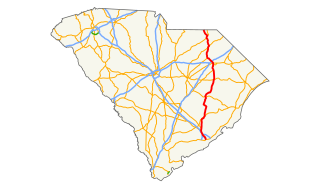
U.S. Route 521 (US 521) is a north–south United States highway that traverses 177.3 miles (285.3 km), from Georgetown, South Carolina to Charlotte, North Carolina. Though numbered as a daughter route of U.S. Route 21, it does not actually intersect its parent or any of its sibling routes, though it is in the same general part of the U.S. as other routes from its family. Historically, it once connected to U.S. 21 in Pineville, North Carolina, but various changes have left it terminating a few miles short of the current U.S. 21.

South Carolina Highway 6 highway in South Carolina

South Carolina Highway 6 is a 115-mile (185 km) state highway that extends from Moncks Corner in Berkeley County to Ballentine in Richland County, near Irmo. It uniquely links all three of the major hydropower projects in South Carolina: Lake Murray, Lake Marion and Lake Moultrie.

South Carolina Highway 34 highway in South Carolina

South Carolina Highway 34 (SC 34) is a primary state highway in the U.S. state of South Carolina. As one of the longer state highways, it traverses the state east-west from Greenwood to Dillon, connecting the cities of Newberry, Winnsboro, Camden, Bishopville and Darlington.

North Carolina Highway 207 highway in North Carolina

North Carolina Highway 207 (NC 207) is a primary state highway in the U.S. state of North Carolina. It is entirely in the boundaries of Union County and serves to connect the city of Monroe to the city of Pageland, South Carolina, at the South Carolina state line via SC 207.

South Carolina Highway 544 highway in South Carolina

South Carolina Highway 544 (SC 544) is a major four-lane highway in Horry County, South Carolina. The highway is sometimes known as Dick Pond Road near the Socastee area. The route begins at U.S. Route 17 Business in Surfside Beach and ends at US 501 Business in Red Hill, near Conway. South Carolina Highway 544 is one of the most frequently traversed highways in the Myrtle Beach area. It runs in a south-north direction and parallels US 501 for most of its route.

South Carolina Highway 46 highway in South Carolina

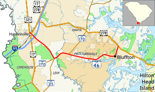
South Carolina Highway 46 (SC 46) is a 17.3-mile-long (27.8 km) state highway in Beaufort and Jasper Counties in the Lowcountry region of South Carolina. It connects the rapidly growing communities of Bluffton and Hardeeville and serves as a parallel route to U.S. Highway 278 (US 278).

South Carolina Highway 28 highway in South Carolina

South Carolina Highway 28 (SC 28) is a primary state highway in the U.S. state of South Carolina. It consists of two segments of highway signed as east–west but physically traveling north-south from the Georgia–South Carolina border near Mountain Rest to Beech Island. It is part of a continuous highway separated by a 17.5-mile (28.2 km) stretch through Augusta, Georgia.

South Carolina Highway 381 highway in South Carolina

South Carolina Highway 381 (SC 381) is a primary state highway in the U.S. state of South Carolina. It connects the towns in eastern Marlboro County.

South Carolina Highway 59 (SC 59) is a 15.6-mile-long (25.1 km) state highway in the northwestern part of the U.S. state of South Carolina. The highway travels in a south-north orientation from just southwest of Fair Play north and then northeast to Seneca, completely within Oconee County.

South Carolina Highway 246

South Carolina Highway 246 (SC 246) is a primary state highway in the U.S. state of South Carolina. It connects the communities and towns in eastern Greenwood County.

South Carolina Highway 403 (SC 403) is a primary state highway in the U.S. state of South Carolina. It serves the town of Timmonsville and the surrounding rural area with the cities of Lake City and Hartsville.

South Carolina Highway 39

South Carolina Highway 39 (SC 39) is a primary state highway in the U.S. state of South Carolina. The highway connects various rural communities and towns from the southwest to the northwest sections of the state.

South Carolina Highway 64

South Carolina Highway 64 (SC 64) is a primary state highway in the U.S. state of South Carolina. It serves the cities of Barnwell and Walterboro while also providing a direct route to Charleston, via U.S. Route 17 (US 17).

South Carolina Highway 173

South Carolina Highway 173 (SC 173) is a primary state highway in the U.S. state of South Carolina. It serves to connect the town of Ridgeville with U.S. Route 78 (US 78).

South Carolina Highway 45

South Carolina Highway 45 (SC 45) is a primary state highway in the U.S. state of South Carolina. It serves as the main thoroughfare in northern Berkeley County.

South Carolina Highway 462 (SC 462) is a primary state highway in the U.S. state of South Carolina. It serves as a circuitous routing through northern and eastern Jasper County.

South Carolina Highway 20

South Carolina Highway 20 (SC 20) is a primary state highway in the U.S. state of South Carolina. The highway connects the cities of Abbeville, Belton, Williamston and Greenville. The 53-mile-long (85 km) highway is signed as a west-east highway though it physically runs south-to-north.

South Carolina Highway 781 (SC 781) is a primary state highway in the U.S. state of South Carolina. It is used as part of a bypass south of Aiken, between Augusta and Williston, in conjunction with U.S. Route 278 (US 278).

References

  1. 1 2 3 "Statewide Highways (shapefile)" (zip). South Carolina Department of Transportation. September 29, 2017. Retrieved December 8, 2017.
  2. 1 2 Google (November 3, 2013). "South Carolina Highway 402" (Map). Google Maps . Google. Retrieved November 3, 2013.
  3. General Highway Map, Berkeley County, South Carolina (PDF) (Map). Cartography by SCDOT. South Carolina Department of Transportation. 1943. Retrieved November 3, 2013.
KML file (edithelp)
KML is not from Wikidata