Related Research Articles

Tunisia, officially the Republic of Tunisia, is the northernmost country in Africa. It is a part of the Maghreb region of North Africa, bordered by Algeria to the west and southwest, Libya to the southeast, and the Mediterranean Sea to the north and east. It features the archaeological sites of Carthage dating back to the 9th century BC, as well as the Great Mosque of Kairouan. Known for its ancient architecture, souks and blue coasts, it covers 163,610 km2 (63,170 sq mi), and has a population of 12.1 million. It contains the eastern end of the Atlas Mountains and the northern reaches of the Sahara desert; much of its remaining territory is arable land. Its 1,300 km (810 mi) of coastline include the African conjunction of the western and eastern parts of the Mediterranean Basin. Tunisia is home to Africa's northernmost point, Cape Angela. Located on the northeastern coast, Tunis is the capital and largest city in the country. Tunisia is named after Tunis.

Tunisia is a country in Northern Africa, bordering the Mediterranean Sea, having a western border with Algeria (965 km) and south-eastern border with Libya (459 km) where the width of land tapers to the south-west into the Sahara. The country has north, east and complex east-to-north coasts including the curved Gulf of Gabès, which forms the western part of Africa's Gulf of Sidra. Most of this greater gulf forms the main coast of Libya including the city of Sirte which shares its root name. The country's geographic coordinates are 34°00′N9°00′E. Tunisia occupies an area of 163,610 square kilometres, of which 8,250 are water. The principal and reliable rivers rise in the north of the country with a few notable exceptions from north-east Algeria and flow through the northern plain where sufficient rainfall supports diverse plant cover and irrigated agriculture.

The Tunisian Sahel or more precisely the Central East Tunisia is an area of central eastern Tunisia and one of the six Tunisian regions. It stretches along the eastern shore, from Hammamet in the north to Mahdia in the south, including the governorates of Monastir, Mahdia, Sfax and Sousse. Its name derives from the Arabic word sāḥil (ساحل), meaning "shore" or "coast". The region's economy is based especially on tourism and it contains the second-biggest airport in Tunisia: Monastir Habib Bourguiba International Airport.
Tataouine is a city in southern Tunisia. It is the capital of the Tataouine Governorate. The below-ground "cave dwellings" of the native Berber population, designed for coolness and protection, render the city and the area around it as a tourist and film makers' attraction. Nearby fortified settlements (ksars), manifestations of Berber architecture, such as Ksar Ouled Soltane, Chenini, Douiret, and Ksar Hadada, are popular tourist sites.

Sfax is a city in Tunisia, located 270 km (170 mi) southeast of Tunis. The city, founded in AD 849 on the ruins of Berber Taparura, is the capital of the Sfax Governorate, and a Mediterranean port. Sfax has a population of 330,440. Its main industries include phosphate, olive and nut processing, fishing and international trade. The city is the second-most populous in the country after the capital, Tunis.

The Mareth Line was a system of fortifications built by France in southern Tunisia in the late 1930s. The line was intended to protect Tunisia against an Italian invasion from its colony in Libya. The line occupied a point where the routes into Tunisia from the south converged, leading toward Mareth, with the Mediterranean Sea to the east and mountains and a sand sea to the west.

Douiret is a ruined Berber village in the Tataouine district in southern Tunisia. Located on a hilltop near a modern village of the same name, Douiret was a fortified granary, or ksar Like other ksour created by North African Berber communities, Douiret was built on a hilltop to help protect it from raiding parties. Douiret is a regular stop on southern Tunisia's ksar trail, along with the villages of Chenini, Ksar Ouled Soltane and Ksar Hadada.

Medenine is one of the 24 governorates (provinces) of Tunisia.

Gabès Governorate is one of the 24 governorates of Tunisia and in south-eastern Tunisia. It covers an area of 7166 km2 and had a population of 374,300 as at the 2014 census. The capital is Gabès.

Tataouine Governorate is the southernmost of the twenty-four governorates of Tunisia, the only one to border both Algeria and Libya. It is also the largest, covering an area of 38,889 km². It had a population of 149,453, nearly tied for second least-populated with Kebili (156,961) after Tozeur (107,912). The capital is Tataouine.

The Nafusa Mountains are a mountain range in the western Tripolitania region of northwestern Libya. It also includes their regions around the escarpment formed where the northern end of the Tripolitanian Plateau meets the Mediterranean coastal plain or the Jefara.
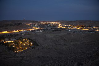
Ghomrassen is a city of southeast Tunisia located 26 km (16 mi) from Tataouine and 40 km (25 mi) from Medenine.
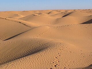
The Grand Erg Oriental is a large erg or "field of sand dunes" in the Sahara Desert. Situated for the most part in Saharan lowlands of northeast Algeria, the Grand Erg Oriental covers an area some 600 km wide by 200 km north to south. The erg's northeastern edge spills over into neighbouring Tunisia.
The delegations of Tunisia are the second level administrative divisions of Tunisia between the governorates and the sectors (imadats). As of 2006 there were 24 governorates which were divided into 264 delegations and further divided into 2073 sectors. The delegations are listed below, organized by governorate.

The Tunisian salt lakes are a series of lakes in central Tunisia, lying south of the Atlas Mountains at the northern edge of the Sahara. The lakes include, from east to west, the Chott el Fedjedj, Chott el Djerid, and Chott el Gharsa.

The Mediterranean woodlands and forests is an ecoregion in the coastal plains, hills, and mountains bordering the Mediterranean Sea and Atlantic Ocean in North Africa. It has a Mediterranean climate, and is in the Mediterranean forests, woodlands, and scrub biome.
Judeo-Tunisian Arabic, also known as Judeo-Tunisian, is a variety of Tunisian Arabic mainly spoken by Jews living or formerly living in Tunisia. Speakers are older adults, and the younger generation has only a passive knowledge of the language.

Tourism in Tunisia is an industry that generates around 9.4 million arrivals per year in 2016, 2017, 2018, 2019 & 2020, which makes it one of the most visited countries in Africa. Tunisia has been an attractive destination for tourists since the beginning of the 1960s.
The Nawara Development Project is a gas development project in Tunisia.
The Établissement de la Radio Tunisienne is Tunisia's state-owned public radio broadcaster. It was formed in August 2007, when the former national state broadcaster ERTT was split into separate radio and television companies. Tunisian Radio operates ten stations, four nationwide and six regionally. It is an active member of the European Broadcasting Union (EBU).
References
- ↑ (in French) Census 2014 (National Institute of Statistics) Archived 2014-10-29 at the Wayback Machine
Governorates and regions of Tunisia | ||
|---|---|---|
| Governorates | ||
| Regions | ||