


The South Melbourne Market is a covered food and general goods market located in South Melbourne, Victoria.
Contents
The market is owned and operated by the City of Port Phillip.
The South Melbourne Market is a covered food and general goods market located in South Melbourne, Victoria.
The market is owned and operated by the City of Port Phillip.
It began operating in 1867, [1] as an outlet for vegetables, fruit and flowers grown by the market gardeners of Cheltenham. [2] It is a Victorian style of building with wood and red brick.
The market is known for its dim sims, which were originally made by chef Ken Cheng. [3]
The market has undergone various refurbishments, including after numerous fires. The worst of these was in 1981 when two of the original sheds were destroyed and, later in the year, stalls were damaged by bombs. [4]
In 2007/2008, the market's produce areas were redesigned, [5] and in 2012 a new roof was added to reduce leaking and heat load. [6]
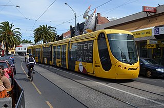
Tram route 96 stops at the light rail station adjacent to the western end of the market. Tram route 12 runs down the nearby Clarendon St, with stop 127 at the corner of York St. Bus route 236 stops at Cecil St on the eastern end of the market.[ citation needed ]
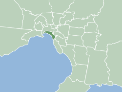
The City of Port Phillip is a local government area of Victoria, Australia on the northern shores of Port Phillip, south of Melbourne's central business district. It has an area of 20.7 km² and had a population of 113,200 in June 2018.

The following is a timeline of the history of the city of Melbourne, Victoria, Australia.

Port Melbourne is an inner-city suburb in Melbourne, Victoria, Australia, 3 km (2 mi) south of the Melbourne central business district, located within the Cities of Melbourne and Port Phillip local government areas. Port Melbourne recorded a population of 17,633 at the 2021 census.

St Kilda Road is a street in Melbourne, Victoria, Australia. It is part of the locality of Melbourne which has the postcode of 3004, and along with Swanston Street forms a major spine of the city.

Melbourne tram route 96 is operated by Yarra Trams on the Melbourne tram network from Brunswick East to St Kilda Beach. The 13.9 kilometre route is operated out of Southbank depot with C2, E class, and on occasion A class trams.
Acland Street is a street in the Melbourne suburb of St Kilda, which enjoys great popularity as a recreational area, mainly due to its many restaurants and its proximity to the entertainment areas along St Kilda beach

Flinders Street is a street in Melbourne, Victoria, Australia. Running roughly parallel to the Yarra River, Flinders Street forms the southern edge of the Hoddle Grid. It is exactly 1 mi (1.6 km) in length and one and a half chains in width.

Westgarth is a neighbourhood within the suburb of Northcote, about 4 or 5 km north-east of Melbourne's central business district in Victoria, Australia. It is in the local government area of the City of Darebin. The neighbourhood has a commercial centre, distinct from the main commercial centre of Northcote, located near Westgarth railway station, just north of Clifton Hill. While Westgarth does not have any official borders, it is generally considered to extend from Merri Creek in the west to the boundary of Fairfield in the east.

Melbourne tram route 109 is operated by Yarra Trams on the Melbourne tram network from Box Hill to Port Melbourne. The 19.3 kilometre route is operated out of Kew depot with A and C class trams.

The Sandridge Bridge is a historic bridge, which originally carried railway lines over the Yarra River in Melbourne, Victoria, Australia. It runs diagonally to the river and is 178.4 metres (585 ft) long. In 2006, it was redeveloped as a pedestrian and cycle path, featuring public art. It is the third bridge on the site and is listed on the Victorian Heritage Register.

La Trobe Street is a major street and thoroughfare in the Melbourne central business district, Victoria, Australia. It runs roughly east–west and forms the northern boundary of the central business district. The street was laid out as an extension of the original Hoddle Grid in 1839 and was named after Charles La Trobe. La Trobe Street extends from Victoria Street in the east to Harbour Esplanade in the west.

Victoria Street is one of the major thoroughfares of inner Melbourne, running east–west for over six kilometres between Munster Terrace in North Melbourne and the Yarra River. The road is known as Victoria Parade for over one-and-a-half kilometres of its length, distinguishable with a wide reservation and tramway down the middle.

Southbank tram depot is located in Southbank, a suburb of Melbourne, Australia. Operated by Yarra Trams, it is one of eight tram depots on the Melbourne tram network.

Melbourne tram route 11 is operated by Yarra Trams on the Melbourne tram network from West Preston to Victoria Harbour. The 13.4-kilometre (8.3 mi) route is operated out of Preston depot with E class trams.

William Street is a major street in the Melbourne central business district, Victoria, Australia. It runs roughly north–south from Flinders Street to Victoria Street, and was laid out in 1837 as part of the original Hoddle Grid. The street is located in-between King Street and Queen Street.

Melbourne Sports Centres – MSAC is an international sporting venue located in Albert Park, Victoria, Australia. The centre was opened on 24 July 1997 at a construction cost of A$65 million. The cost was funded by the State Government of Victoria and the City of Port Phillip. The centre has hosted international events including the 2006 Commonwealth Games and the 2007 World Aquatics Championships.
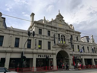
Prahran Market is a food market in South Yarra, Melbourne, Victoria, Australia. Located on Commercial Road near Chapel Street, it was established in neighbouring Prahran in the 1860s before moving to its present location in 1881.

The Sandridge Trail is a shared-use path for cyclists and pedestrians located in the inner southern suburb of Port Melbourne in Melbourne, Victoria, Australia.

Melbourne tram route 12 is operated by Yarra Trams on the Melbourne tram network from Victoria Gardens Shopping Centre to St Kilda. The 16.2-kilometre (10.1 mi) is operated out of Southbank depot with A class trams.

St Vincent's Plaza is a major interchange of the Melbourne tram network, serviced by Yarra Trams routes 11, 12, 30 and 109. It is located in the wide centre median of Victoria Parade, wedged between the intersections of Gisborne Street and Brunswick Street.
37°49′58″S144°57′21″E / 37.83278°S 144.95583°E
| | This article about a place in Melbourne is a stub. You can help Wikipedia by expanding it. |