Related Research Articles

North Devon is a local government district in Devon, England. Its council is based just outside Barnstaple, the district's largest town. The district also includes the towns of Ilfracombe, Lynton and Lynmouth and South Molton along with numerous villages and surrounding rural areas.

North Devon is a constituency represented in the House of Commons of the UK Parliament since 2019 by Selaine Saxby of the Conservative Party.
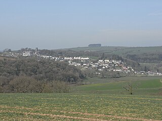
South Molton is a town and civil parish in Devon, England. It is part of the North Devon local government district. The town is on the River Mole.

Anstey is a village and civil parish in the East Hertfordshire district of Hertfordshire, England, about 15 miles (24 km) northeast of Stevenage. According to the 2001 census the population of the parish was 338, reducing to 299 at the 2011 census.

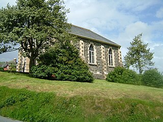
East Anstey is a village and civil parish in the North Devon district of Devon, England. The parish is located in an area which has been designated as an area of 'Great Landscape Value'. The village falls within the South Molton Deanery for ecclesiastical purposes. The village has a Grade II listed church, the Church of St Michael, which has a 15th-century tower and south porch but which was largely rebuilt in 1871.

High Bickington is a rural village and civil parish in the Torridge district of Devon, England. The village lies on the B3217 road, around 6 miles (10 km) east of Great Torrington, 8 miles (13 km) south-west of South Molton, and 8 miles (13 km) south of Barnstaple. At the 2011 Census, the parish had a population of 837.
Brayford is a village and civil parish in Devon, England, situated about 5 miles (8.0 km) from South Molton and 6 miles (9.7 km) from Barnstaple. It lies on Exmoor and sits beneath open areas of common land. It is a small rural community and in the surrounding area are many farms.
Twitchen is a village and civil parish in Devon, England, located within the North Devon local authority area. Historically it formed part of South Molton Hundred. The population was 145 in 1801; 163 in 1901 and 70 in 2001. Twitchen is recorded in the Domesday Book as being part of the manor of Alvred D'Epaignes having been held by freely by Beorhtweald in the time of King Edward, before the Norman conquest in 1066.

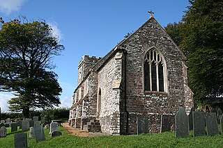
Molland is a small village, civil parish, dual ecclesiastical parish with Knowstone, located in the foothills of Exmoor in Devon, England. It lies within the North Devon local government district. At the time of the 2001 Census, the village had 203 inhabitants. Molland was first referenced as the Manor of Molland in the Domesday Book. The village contains a church dating back to the 1400s.
North Molton is a village, parish and former manor in North Devon, England. The population of the parish in 2001 was 1,047, decreasing to 721 in the 2011 census. An electoral ward with the same name also exists. The ward population at the census was 2,206. Bounded on the north east by the border with Somerset, it is the second largest parish in Devon, covering about 15,000 acres. Until the 18th century the village was an important centre of the woollen industry, and mining was also a significant employer in the parish until the 19th century.
Devon League 1 is an English level eight rugby union league for clubs based in Devon. The champions are promoted to Cornwall/Devon and the runner-up plays the second team from Cornwall League 1, with the winning team gaining promotion. Up until the end of the 2017–18 season, teams were relegated to Devon League 2 but since that league has been abolished there is currently no relegation.

South Radworthy is a hamlet in the civil parish of North Molton, in the North Devon District of the county of Devon, England. It is about three miles to the north of the village of North Molton and about fifteen miles to the east of the town of Barnstaple. The hamlet sits on an unclassified road and is surrounded by woodland.

North Radworthy is a hamlet and historic estate in the civil parish and former manor of North Molton, in the North Devon district of the county of Devon, England. It is about three miles north of the village of North Molton, and about fifteen miles to the east of the town of Barnstaple. The hamlet sits on an unclassified road, and is surrounded to the north, south and west by woodland. North Radworthy Farm is the centre of the historic estate.

The Mayor of South Molton in Devon is an ancient historical office which survives at the present time. In the Middle Ages the town of South Molton was incorporated by royal charter into a borough governed by a mayor and Corporation. This enabled the inhabitants to free themselves from the jurisdiction of the lord of the manor of South Molton and to subject themselves instead to the jurisdiction of the king.

George Nympton or Nymet St George is a small village and civil parish in North Devon district, Devon, England. In the 2011 census it was recorded as having a population of 175.

Satterleigh and Warkleigh is a civil parish in North Devon district, Devon, England. In the 2011 census it was recorded as having a population of 170.

West Anstey is a village and civil parish on the River Yeo, about 5 miles west of Dulverton, in the North Devon district, in the county of Devon, England. In 2011 the parish had a population of 163. The parish touches Molland, East Anstey and Withypool and Hawkridge.
South Molton Rural District was a rural district in the administrative county of Devon, England, from 1894 to 1974, covering an area in the north of the county. The district was named after the town of South Molton and had its offices there. The town itself was initially excluded from the rural district, being a self-governing municipal borough. In 1967 the town was absorbed into the district.
References
- 1 2 "THE HUNDREDS OF DEVON". GENUKI. Retrieved 8 April 2018.
| | This Devon location article is a stub. You can help Wikipedia by expanding it. |