
Sydney is the state capital of New South Wales and the most populous city in Australia and Oceania. Located on Australia's east coast, the metropolis surrounds Port Jackson and extends about 70 km (43.5 mi) on its periphery towards the Blue Mountains to the west, Hawkesbury to the north, the Royal National Park to the south and Macarthur to the south-west. Sydney is made up of 658 suburbs, 40 local government areas and 15 contiguous regions. Residents of the city are known as "Sydneysiders". As of June 2017, Sydney's estimated metropolitan population was 5,131,326, and is home to approximately 65% of the state's population.

Camperdown is an inner western suburb of Sydney, in the state of New South Wales, Australia. Camperdown is located 4 kilometres south-west of the Sydney central business district and is part of the Inner West region. Camperdown lies across the local government areas of the City of Sydney and Inner West Council.

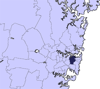
The Strathfield Council is a local government area located in the inner west region of Sydney, in the state of New South Wales, Australia.

The Inner West is the metropolitan area directly west of the Sydney central business district, New South Wales, Australia. The suburbs of the Inner West are predominantly located along the southern shore of Port Jackson, stretching south to the shores of the Cooks River. The far western suburbs within this region lie in the Cumberland Plain.

The Sydney light rail network is a light rail system serving the Australian city of Sydney, New South Wales. The network currently consists of a single 12.8-kilometre (8 mi) line with 23 stations, known as the Dulwich Hill Line.
Southern Sydney is the southern metropolitan area of Sydney, in the state of New South Wales, Australia.
The City of Sydney is the local government area covering the Sydney central business district and surrounding inner city suburbs of the greater metropolitan area of Sydney, New South Wales, Australia. Established by Act of Parliament in 1842, the City of Sydney is the oldest, and the oldest-surviving, local government authority in New South Wales, and the second-oldest in Australia, with only the City of Adelaide being older by two years.
Sydney is the state capital of New South Wales and the most populous city in Australia.

The Australian state of New South Wales has an extensive network of railways, which were integral to the growth and development of the state. The vast majority of railway lines were government built and operated, but there were also several private railways, some of which operate to this day.

George Street is a street in the central business district of Sydney in New South Wales, Australia.
South Western Sydney is a region of the metropolitan area in south west Sydney, New South Wales, Australia. It is part of the predominantly working class area of Greater Western Sydney. The region lies in the Cumberland Plain.
South railway line in Sydney, Australia may refer to:
The Division of Watson was an Australian Electoral Division in the state of New South Wales. It was located in the inner southern suburbs of Sydney, and originally included the suburbs of Coogee, Kensington and Maroubra. By the time it was abolished in 1968, it covered the suburbs of Banksmeadow, Mascot and Redfern.

Liberty Grove is a suburb in the Inner West of Sydney, in the state of New South Wales, Australia.

St Peters is a suburb in the Inner West of Sydney, in the state of New South Wales, Australia. It is 7 kilometres south of the Sydney central business district, in the local government area of Inner West Council.
Mortlake is a suburb in the Inner West of Sydney, in the state of New South Wales, Australia. It is 17 kilometres west of the Sydney central business district, in the local government area of the City of Canada Bay.
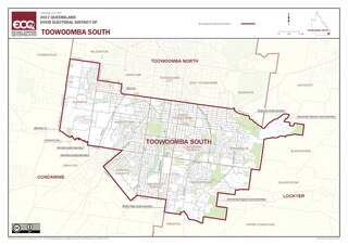
Toowoomba South is an electoral district of the Legislative Assembly in the Australian state of Queensland. It was created with the 1972 redistribution, and replaced the abolished Toowoomba East.

The Main Suburban railway line is the technical name for the trunk railway line between Redfern railway station and Parramatta railway station in Sydney, Australia, but now generally refers to the section between Redfern and where the Old Main South Line branches off at Granville Junction. The railway line then continues on as the Main Western line towards the Blue Mountains. This term distinguished this trunk line from the Illawarra Line which branched south from the Illawarra Junction to Wollongong, and later the North Shore tracks which carried trains north over the Harbour Bridge.
This is a list of freeways in Australia, sorted by states and territories and their corresponding routes. This list includes tollways / toll roads such as the CityLink freeway system in Melbourne. This list has over 70 entries. The only jurisdiction in Australia without freeways is the Northern Territory. Victoria has the largest and densest freeway network in Australia.