
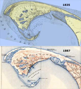
Cape Cod is a hook-shaped peninsula extending into the Atlantic Ocean from the southeastern corner of Massachusetts, in the northeastern United States. Its historic, maritime character and ample beaches attract heavy tourism during the summer months. The name Cape Cod, coined in 1602 by Bartholomew Gosnold, is the ninth oldest English place-name in the U.S.
The Cape Cod National Seashore (CCNS) encompasses 43,607 acres on Cape Cod, in Massachusetts. CCNS was created on August 7, 1961, by President John F. Kennedy, when he signed a bill enacting the legislation he first co-sponsored as a Senator a few years prior. It includes ponds, woods and beachfront of the Atlantic coastal pine barrens ecoregion. The CCNS includes nearly 40 miles (64 km) of seashore along the Atlantic-facing eastern shore of Cape Cod, in the towns of Provincetown, Truro, Wellfleet, Eastham, Orleans and Chatham. It is administered by the National Park Service.

Provincetown is a New England town located at the extreme tip of Cape Cod in Barnstable County, Massachusetts, in the United States. A small coastal resort town with a year-round population of 3,664 as of the 2020 United States Census, Provincetown has a summer population as high as 60,000. Often called "P-town" or "P'town", the locale is known for its beaches, harbor, artists, tourist industry, and as a popular vacation destination for the LGBT+ community.

Truro is a town in Barnstable County, Massachusetts, United States, comprising two villages: Truro and North Truro. Located slightly more than 100 miles (160 km) by road from Boston, it is a summer vacation community just south of the northern tip of Cape Cod, in an area known as the "Outer Cape". English colonists named it after Truro in Cornwall, United Kingdom.

Provincetown Harbor is a large natural harbor located in the town of Provincetown, Massachusetts. The harbor is mostly 30 to 90 feet deep and stretches roughly 1 mile (1.6 km) from northwest to southeast and 2 miles (3.2 km) from northeast to southwest – one large, deep basin with no dredged channel necessary for boats to enter and exit.
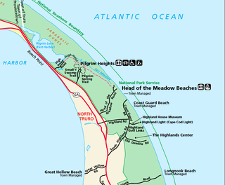
North Truro is a village in the town of Truro, Massachusetts, United States. Due to its proximity to urbanized Provincetown, it is somewhat more densely developed than the rest of the town, with houses and small resort facilities lining the two main thoroughfares, U.S. Route 6 and MA Route 6A. It is home to Truro Vineyards, one of two operating wineries on Cape Cod. North Truro is located at 42°03′35″N70°08′31″W.

The Old Colony Railroad (OC) was a major railroad system, mainly covering southeastern Massachusetts and parts of Rhode Island, which operated from 1845 to 1893. Old Colony trains ran from Boston to points such as Plymouth, Fall River, New Bedford, Newport, Providence, Fitchburg, Lowell and Cape Cod. For many years the Old Colony Railroad Company also operated steamboat and ferry lines, including those of the Fall River Line with express train service from Boston to its wharf in Fall River where passengers boarded luxury liners to New York City. The company also briefly operated a railroad line on Martha's Vineyard, as well as the freight-only Union Freight Railroad in Boston. The OC was named after the "Old Colony", the nickname for the Plymouth Colony.

The Cape Cod Railroad is a railroad in southeastern Massachusetts, running from Pilgrim Junction in Middleborough across the Cape Cod Canal Railroad Bridge, where it splits towards Hyannis in one direction and Falmouth in the other. It was incorporated in 1846 as the Cape Cod Branch Railroad to provide a rail link from the Fall River Railroad line in Middleborough to Cape Cod.

The Cape Codder was a seasonal passenger train operated by Amtrak between New York City and Hyannis, Massachusetts, on Cape Cod. It operated during the summer between 1986 and 1996. It was the first regular service from New York to the Cape since 1964. The New York, New Haven and Hartford Railroad previously had operated a train under this name until 1958.

The Cape Cod Rail Trail (CCRT) is a 25.5-mile (41.0 km) paved rail trail located on Cape Cod in Massachusetts. The trail route passes through the towns of Yarmouth, Dennis, Harwich, Brewster, Orleans, Eastham, and Wellfleet. It connects to the 6-plus mile (10 km) Old Colony Rail Trail leading to Chatham, the 2 mile Yarmouth multi-use trail, and 8 miles (13 km) of trails within Nickerson State Park. Short side trips on roads lead to national seashore beaches including Coast Guard Beach at the end of the Nauset Bike Trail in Cape Cod National Seashore. The trail is part of the Claire Saltonstall Bikeway.

Provincetown station was a train station located on Bradford Street between Alden and Standish Streets in Provincetown, Massachusetts.

North Truro station was a train station located in North Truro, Massachusetts near the intersection of what is now Pond and Twinefield Roads.

The Hyannis Transportation Center (HTC) is an intermodal transportation center in Hyannis, Massachusetts, operated by the Cape Cod Regional Transit Authority (CCRTA). It is the terminus for several CCRTA bus lines and its CapeFLYER passenger train that operates on summer weekends between Boston South Station and Hyannis. It is also used by the Plymouth and Brockton Street Railway, Peter Pan Bus Lines, and Greyhound via CapeBus intercity bus services. The Cape Cod Central Railroad uses a separate station building across the tracks for its excursion services. A rail yard used by the Cape Cod Central is located north of the station, along with a former roundhouse.

Yarmouth station was a railroad station in the Yarmouth Port section of Yarmouth, Massachusetts.

The Jenny Lind Tower is a stone tower located in North Truro, Massachusetts. It is named after the 19th-century opera singer Jenny Lind, who is rumored to have climbed the tower when it was located in Boston to prevent a riot among people who were unable to attend her concert. It is located roughly between the Highland Light lighthouse and North Truro Air Force Station. It is seventy feet tall.

The Cape Cod Central Railroad was a railroad in southeastern Massachusetts, more specifically in central Cape Cod. It was incorporated in 1861 to extend the Cape Cod Railroad from Yarmouth to Orleans through the towns of Dennis, Harwich and Brewster. The 18.7 mile line opened for service in December, 1865.

The CapeFlyer is a passenger rail service in Massachusetts between Boston and Cape Cod that began in 2013. It is operated by the Cape Cod Regional Transit Authority (CCRTA) in collaboration with the Massachusetts Bay Transportation Authority (MBTA) and the Massachusetts Department of Transportation (MassDOT). The service runs on the weekends, beginning Friday evenings and including holidays, between Memorial Day weekend and Labor Day weekend.
East Harbor is a tidal estuary in Truro, Massachusetts that was originally a harbor until it was cut off from Cape Cod Bay to form a salt marsh lagoon, later renamed Pilgrim Lake. It is now within the Cape Cod National Seashore.
Bourne station is a train station in Bourne, Massachusetts, served by the CapeFlyer.
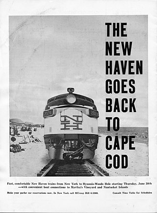
The Cape Codder was a pair of day and night passenger trains run by the New York, New Haven and Hartford Railroad (NH) from the latter 1920s to the mid 1960s, with some brief interruptions. Its distinction was the longest tenure of direct summertime New York City to Cape Cod trains. With the improvement of highways in southeastern Massachusetts, passenger rail traffic diminished, and the Cape Codder service ended with the New Haven Railroad's discontinuing of passenger rail service to Cape Cod.
