Related Research Articles

Portage County is a county in the U.S. state of Wisconsin. As of the 2020 census, the population was 70,377. Its county seat is Stevens Point.

Marathon County is a county located in the U.S. state of Wisconsin. As of the 2020 census, the population was 138,013. Marathon County's seat is Wausau. It was founded in 1850, created from a portion of Portage County. At that time the county stretched to the northern border with the upper Michigan peninsula. It is named after the battlefield at Marathon, Greece.

Dane County is a county in the U.S. state of Wisconsin. As of the 2020 census, the population was 561,504, making it the second-most populous county in Wisconsin. The county seat is Madison, which is also the state capital.
Wayne Heights is a census-designated place (CDP) in Franklin County, Pennsylvania, United States. The population was 2,606 at the 2020 census.
Hazelhurst is a town in Oneida County, Wisconsin, United States. The population was 1,267 at the 2000 census. The unincorporated community of Hazelhurst is located in the town.

Wisconsin Rapids is a city in and the county seat of Wood County, Wisconsin, United States. The population was 18,877 at the 2020 census. The city also forms one of the core areas of the United States Census Bureau's Marshfield-Wisconsin Rapids Micropolitan Statistical Area, which includes all of Wood County and had a 2020 population of 74,207.

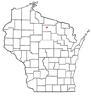
Milladore is a village in Wood County and overlapping into Portage County in the U.S. state of Wisconsin. The population was 276 at the 2010 census. Most of the village is located within the Town of Milladore in Wood County, while only a very small portion of the village lies in Portage County. All of its 2010 census population resided in the Wood County portion of the village.

Merrill is a city in and the county seat of Lincoln County, Wisconsin, United States. It is located to the south of and adjacent to the Town of Merrill. The population was 9,347, according to the 2020 census. Merrill is part of the United States Census Bureau's Merrill MSA, which includes all of Lincoln County. Together with the Wausau MSA, which includes all of Marathon County, it forms the Wausau-Merrill CSA.

In the U.S. state of Wisconsin, the Central Plain is a geographical region consisting of about 13,000 square miles (34,000 km2) of land in a v-shaped belt across the center of the state. Beginning in the west, the Central Plain originates in Burnett and Polk Counties and runs southeast to Columbia County, where it turns northeast and reaches its end in Marinette County.

Lake St. Helen is a 2,400-acre (9.7 km2) public lake located in Roscommon County in the U.S. state of Michigan, and borders on the community of St. Helen, Michigan. It is the headwaters for the south branch of the Au Sable River. From 1998 to 2003, the Lake was subject to a water weed (millfoil) eradication project, involving weevil restocking, which was successful at the time. Fishing is available throughout the lake, albeit different fish are found in different places, and includes: Largemouth bass, bluegill, crappie, perch, pike, and walleye. A Bluegill Festival is held each summer.

Blenker is an unincorporated community in the town of Milladore, in Wood County, Wisconsin, United States.
Bancroft is an unincorporated census-designated place in Portage County, Wisconsin, United States. As of the 2010 census, its population is 535. It is included in the Stevens Point, Wisconsin Micropolitan Statistical Area.
The Yellow River is a tributary of the Wisconsin River in Clark, Wood and Juneau counties in Wisconsin, in the United States.
Dexterville is an unincorporated community in the town of Dexter, Wood County, Wisconsin, United States. It is located at the intersection of Wisconsin Highway 80 and Wisconsin Highway 54.
Bayouville is an unincorporated community in New Madrid County, in the U.S. state of Missouri.
Brent is an extinct town in Pemiscot County, in the U.S. state of Missouri. The GNIS classifies it as a populated place.
Gaynor Park is an urban park located in and administered by the city of Wisconsin Rapids, Wisconsin.
Lyon Park is an urban park located in and administered by the city of Wisconsin Rapids, Wisconsin.
North Wood County Park is a county park in the U.S. state of Wisconsin. North Wood County Park was so named for its location relative to nearby South Wood County Park.
Robinson Park is an urban park located in and administered by the city of Wisconsin Rapids, Wisconsin. The park was named after Dr. F. Byron Robinson, the original owner of the site.
References
- ↑ U.S. Geological Survey Geographic Names Information System: South Wood County Park
- ↑ Rudolph, Robert S. (1970). Wood County Place Names (PDF). The University of Wisconsin Press. p. 79.
- 1 2 "South Wood County Park". Wood County. Retrieved 28 March 2018.
44°21′51″N89°44′26″W / 44.36417°N 89.74056°W
| | This article about a location in Wood County, Wisconsin is a stub. You can help Wikipedia by expanding it. |