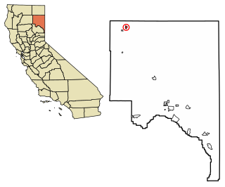
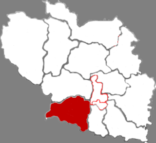
Lassen County is a county in the northeastern portion of the U.S. state of California. As of the 2010 census, the population was 34,895. The county seat and only incorporated city is Susanville.

Black Canyon City is a census-designated place (CDP) in Yavapai County, Arizona, United States. The population was 2,697 at the 2000 census.

Fall River Mills is an unincorporated town and census-designated place (CDP) in Shasta County, California, United States. The population was 573 as of the 2010 census.

Franklin is a town in Jackson County, Wisconsin, United States. The population was 325 at the 2000 census. The unincorporated community of Franklin is located in the town. The ghost town of Rogneys was also located in the town.

AAR CORP. is an independent provider of aviation and expeditionary services to the global commercial, government and defense aviation industries.
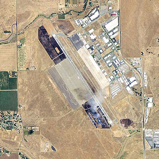
Chico Municipal Airport, often called CMA, is four miles (6 km) north of Chico, in Butte County, California. The airport covers 1,475 acres (6.0 km2), has two runways and one helipad; its fixed-base operator, "Northgate Aviation"., provides fuel, maintenance, flight training, and charter flights. The airport has seen airline jets, but no passenger airline serves Chico since United Express ended flights to San Francisco.

Baker's Haulover Inlet is a man-made channel in Miami-Dade County, Florida connecting the northern end of Biscayne Bay with the Atlantic Ocean, at coordinates 25°53′59″N80°07′26″W. The inlet was cut in 1925 through a narrow point in the sand between the cities of Bal Harbour and Sunny Isles. It is the location of an official nude beach, recreation areas and marina in the 99-acre Haulover Park. A fixed bridge carries SR A1A across the inlet.
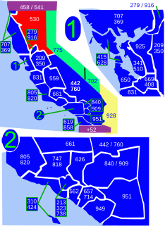
Area code 530 is a California telephone area code in northeastern and Northern California.

Northwest or northwestern Ohio consists of multiple counties in the northwestern corner of the United States state of Ohio. This area borders Lake Erie, Southeast Michigan, and eastern Indiana. Some areas in northwestern Ohio are also considered the Black Swamp area. The Toledo metropolitan area is also part of the region. Just like any other region, there is no universally agreed-upon boundary for northwestern Ohio, as the entire area is defined differently by the opinions of multiple people.
Yancey is an unincorporated community in Medina County, Texas, United States. It is approximately 12 miles south of Hondo and is part of the San Antonio Metropolitan Statistical Area. According to an online community profile, Yancey has a population of 649 people. It has an Oil Business and a RV repair business. Also, it has a Restaurant called "Red's Place". Not only that, Yancey has many more businesses in their town. For example, A fire department, post office, and a water company. http://www.homepages.com/localpages/Texas/Yancey/YanceyProfile.htm]
The Berry Creek Rancheria of Tyme Maidu Indians are a Native American people inhabiting a northeastern part California, south of Lassen Peak.
The Big Bend Rancheria of the Pit River Tribe (Achomawi) is located just north of Big Bend, in Shasta County, California. It is about 50 miles (80 km) northeast of Redding.
Mill Creek is a small town in Tehama County, California most noted for its close location to Lassen Peak. It is located at an elevation of 4737 feet.

Beaver County Airport or is a county-owned public airport three miles northwest of Beaver Falls, in Beaver County, Pennsylvania.

Talopram, also known as phthalapromine, is a selective norepinephrine reuptake inhibitor (NRI) which was researched for the management of depression in the 1960s and 1970s but was never commercialized. Along with talsupram, talopram is structurally related to the selective serotonin reuptake inhibitor (SSRI) citalopram, as well as to melitracen:
Argusville is a former settlement in Lassen County, California. It was located 3 miles (4.8 km) north of Bieber.
Addington is a former settlement in Lassen County, California. It was located 15 miles (24 km) southeast of Hayden Hill.
Zhangzi County is a county in the southeast of Shanxi province, China. It is under the administration of the prefecture-level city of Changzhi.
Kaavere is a village in Põltsamaa Parish, Jõgeva County in eastern Estonia.
Bešište is a village in Municipality of Prilep, Republic of Macedonia.