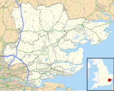
Southend-on-Sea, commonly referred to as Southend, is a coastal city and unitary authority area with borough status in south-eastern Essex, England. It lies on the north side of the Thames Estuary, 40 miles (64 km) east of central London. It is bordered to the north by Rochford and to the west by Castle Point. The city is one of the most densely populated places in the country outside of London. It is home to the longest pleasure pier in the world, Southend Pier, while London Southend Airport is located to the north of the city centre.

Castle Point is a local government district with borough status in south Essex, England, lying around 30 miles (48 km) east of London. The borough comprises the towns of South Benfleet, Hadleigh and Thundersley on the mainland, and the adjoining Canvey Island in the Thames Estuary, which is connected to the mainland by bridges.

The Borough of Basildon is a local government district with borough status in Essex, England. It is named after its largest town, Basildon, where the council is based. The borough also includes the towns of Billericay and Wickford and surrounding rural areas.
Rochford is a local government district in Essex, England. It is named after one of its main settlements, Rochford, where the council is based. The largest town in the district is Rayleigh. Other places in the district include Hockley, Ashingdon, Great Wakering, Canewdon and Hullbridge.

Beecroft Art Gallery is an art gallery in Southend-on-Sea, Essex, England. The gallery is housed in the former municipal central library that opened in 1974 in the brutalist style as part of Southend Civic Centre. The Beecroft Art Gallery has a busy programme of changing exhibitions of art, photography and fashion. On the ground floor, the gallery presents temporary exhibitions of modern and contemporary artists, focusing on the work of emerging and established local artists. On the first floor, visitors can see works from the permanent collection and exciting fashion exhibitions. In the basement of the building is the charity The Jazz Centre UK.

Westcliff railway station is on the London, Tilbury and Southend line, serving the locality of Westcliff-on-Sea in Southend-on-Sea, Essex. It is 34 miles 66 chains (56.0 km) down the main line from London Fenchurch Street via Basildon and it is situated between Chalkwell to the west and Southend Central to the east. Its three-letter station code is WCF.

Wickford is a town and civil parish in the south of the English county of Essex, with a population of 33,486. Located approximately 30 miles (50 km) east of London, it is within the Borough of Basildon along with the original town of Basildon, Billericay, Laindon and Pitsea.

The A127, also known as the Southend Arterial Road, is a major road in Essex, England. It was constructed as a new arterial road project in the 1920s, linking Romford with Southend-on-Sea, replacing the older A13. Formerly classified as a trunk road, it was "de-trunked" in 1997. It is known as the Southend Arterial Road except for part of its length in Southend-on-Sea. It is also streetlit for its whole length despite its majority coverage through rural land.

First Essex is a bus company operating services in the county of Essex. It is a subsidiary of FirstGroup.

Pitsea is a town and former civil parish in the Borough of Basildon in south Essex, England. It comprises five sub-districts: Eversley, Northlands Park Neighbourhood, Chalvedon, Pitsea Mount and Burnt Mills. It is part of the new town of Basildon.

County Borough of Southend-on-Sea was a local government district around the seaside resort of Southend-on-Sea in Essex, England. South End, as it was originally known was initially some fishermen's huts at the south end of the village of Prittlewell. Due to the growth of the settlement and the arrival of the ecclesiastical parish of St John the Baptist, in 1842, Southend formed a local board. In 1877, the local board merged back with Prittlewell, with the new Southend district also including the settlements of Westcliff-on-Sea and Chalkwell. When Essex County Council was formed in 1889, Southend was within the administrative county of Essex. The town was officially incorporated by charter as a municipal borough in 1892, and the council, known as Southend Corporation, changed the name of the town from Southend to Southend-on-Sea in 1893. Due to the rapid expansion of the town's population, in 1914 the town was made a county borough, divorcing itself from the county council and taking control of all the town's services. In 1974 the county borough was dissolved, and replaced by a non-metropolitan district within the same boundaries. Two new authorities were created, with the powers split between Essex County Council and Southend-on-Sea District Council. The town became a unitary authority area in 1998, which returned the powers from the county council that had been lost in 1974.

Essex County Council is the county council that governs the non-metropolitan county of Essex in England. It has 75 councillors, elected from 70 divisions, and has been under Conservative majority control since 2001. The council meets at County Hall in the centre of Chelmsford. It is a member of the East of England Local Government Association.

Eastern National was a bus company operating in south-east England, primarily in Essex, from 1929 to the 1990s.

Southend University Hospital is an NHS hospital located in Westcliff-on-Sea, Southend-on-Sea, Essex. It is managed by Mid and South Essex NHS Foundation Trust.
Chase High School is a coeducational secondary school and sixth form, located in Westcliff-on-Sea, Essex, England.

South Essex College of Further and Higher Education, also known as South Essex College, is a further education college located in several campuses in Basildon, Southend-on-Sea and Grays in Essex, England. The college provides courses for students of 16 years old and upwards.

Southend-on-Sea City Council is the local authority of the city of Southend-on-Sea, in the ceremonial county of Essex, England. Southend has had an elected local authority since 1866, which has been reformed several times. Since 1998 the council has been a unitary authority, being a district council which also performs the functions of a county council; it is independent from Essex County Council

Milton is an electoral ward of Southend-on-Sea, in the ceremonial county of Essex, England, covering the seafront area west of Southend town centre and the eastern side of the inner city area of Westcliff-on-Sea. It is represented by three local government councillors, each elected to serve a four-year term. The ward borders Chalkwell, Kursaal and Victoria and the Castle Point ward of Canvey Island East. In 2021 it had a population of 11,692.

Southend Court House is a Crown Court venue which deals with criminal cases, as well as a County Court venue, which deals with civil cases, in Victoria Avenue, Southend-on-Sea, England. Located immediately to the south of Southend Civic Centre, it is also the venue for magistrates' court hearings.