Related Research Articles
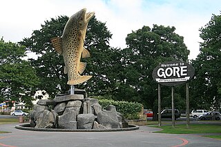
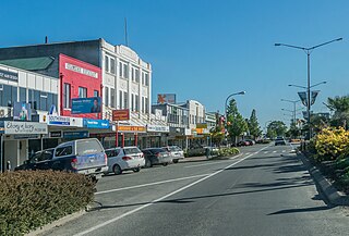
Gore is a town and district in the Southland region of the South Island of New Zealand. It has a resident population of 8,240 as of June 2023. Gore is known for its country music scene and hosts an annual country music festival. The town is also surrounded by farmland and is an important centre for agriculture in the region.
Mataura is a town in the Southland region of the South Island of New Zealand. Mataura has a meat processing plant, and until 2000 it was the site of a large pulp and paper mill.

Southland District is a New Zealand territorial authority district that covers most of the southern end of the South Island as well as Stewart Island.
The Southland Plains is a general name given to several areas of low-lying land in the South Island of New Zealand, separated by the rise of the Hokonui Hills in the north. It forms a sizeable area of Southland region and encompasses its two principal settlements the city of Invercargill and the town of Gore. The Southland Plains include some of New Zealand's most fertile farmland.

The Southland Province was a province of New Zealand from March 1861, when it split from Otago Province, until 1870, when it rejoined Otago.

Dacre is a small town in the South Island of New Zealand. It is situated on the Southland Plains between Invercargill and Edendale on State Highway 1. In Dacre, SH 1 is met by State Highway 98, which runs west to Makarewa via Rakahouka. Nearby villages include Mabel Bush to the northwest and Woodlands to the southeast. Dacre is 25 km north east of Invercargill, the closest city. The Main South Line railway passes just to the south of Dacre. It is a dairy farming community, that currently has a community hall and a small engine garage.
Waitane is a locality in the Southland region of New Zealand's South Island in the foothills of the Hokonui Hills. It is located in a rural setting on State Highway 96 between Glencoe and Te Tipua. The nearest sizeable town is Mataura to the east, while the main city of Southland, Invercargill, is southwest.
Te Tipua is a rural farming community in the eastern Southland region of New Zealand's South Island.
Gore District Council is the territorial authority for the Gore District of New Zealand.
Titiroa is a locality in the Southland region of New Zealand's South Island. It is on the eastern bank of the lower Mataura River, inland from Toetoes Bay. Pine Bush is nearby to the northeast, and Waimahaka is to the southeast.
Gorge Road is a locality in the Southland region of New Zealand's South Island. It is on the Southern Scenic Route and is situated on the western bank of the Mataura River. Nearby settlements include Ashers to the west, and across the Mataura, Pine Bush and Titiroa to the east.
Wallace was a New Zealand parliamentary electorate. It was established in 1858, the first election held in 1859, and existed until 1996. From 1861 to 66, it was represented by two members. In total, there were 18 Members of Parliament from the Wallace electorate.
Mataura was a parliamentary electorate in the Southland Region of New Zealand, from 1866 to 1946.
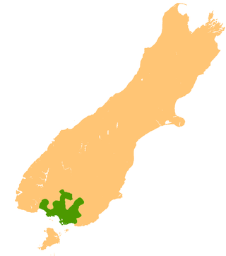
Gore District is a district in the Southland Region of the South Island of New Zealand. It is named for Gore, the district's biggest township.

Southland is New Zealand's southernmost region. It consists of the southwestern portion of the South Island and includes Stewart Island. Southland is bordered by the culturally similar Otago Region to the north and east, and the West Coast Region in the extreme northwest. The region covers over 3.1 million hectares and spans 3,613 km of coastline. As of June 2023, Southland has a population of 103,900, making it the eleventh-most-populous New Zealand region, and the second-most sparsely populated. Approximately half of the region's population lives in Invercargill, Southland's only city.

Stirling Point is a landmark at the southern end of the New Zealand town of Bluff, New Zealand. It is notable as the southern end of both State Highway 1 and Te Araroa; both these facilities span the length of the country. Stirling Point hosts a signpost with multiple directional signs; it is one of the most photographed items in Southland. Stirling Point has an anchor chain sculpture which replicates the sculpture on Stewart Island.
Mataura Island is a farming community in Southland, New Zealand. It is located close to the east bank of the lower reaches of the Mataura River. Despite its name, it is no longer an island. Mataura Island is located some 40 kilometres (25 mi) east of the region's main city of Invercargill, and 15 kilometres (9.3 mi) south of the town of Edendale, on the Awarua Plains and close to the western edge of The Catlins.

The Southern District Health Board was a district health board which provided healthcare to an area covering the southern half of the South Island of New Zealand. In July 2022, the Southern DHB was dissolved as part of a nationwide overhaul of the district health board system. Its former functions and responsibilities were taken over by Te Whatu Ora.
The Ensign is a regional newspaper based in Gore, New Zealand published on Wednesdays and Fridays by Allied Press Ltd. It was first published in 1878 as The Mataura Ensign and changed to its current name in 1973. The newspaper features coverage of local government, sports and recreation, arts and entertainment, education, farming and business news. It is currently distributed to approximately 12,000 homes over a circulation area that includes Gore and the surrounding area that stretches from Mandeville and Waikaka in the north to Mataura in the south.
References
- ↑ NZMS 10A, Sheet 31 (1961), Sheet 34 (1963)
46°06′S168°36′E / 46.1°S 168.6°E
| | This Southland Region geography article is a stub. You can help Wikipedia by expanding it. |