Related Research Articles

Upwelling is an oceanographic phenomenon that involves wind-driven motion of dense, cooler, and usually nutrient-rich water from deep water towards the ocean surface. It replaces the warmer and usually nutrient-depleted surface water. The nutrient-rich upwelled water stimulates the growth and reproduction of primary producers such as phytoplankton. The biomass of phytoplankton and the presence of cool water in those regions allow upwelling zones to be identified by cool sea surface temperatures (SST) and high concentrations of chlorophyll-a.

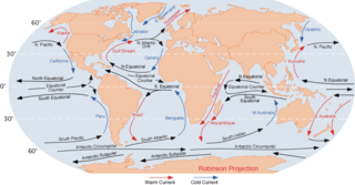
An ocean current is a continuous, directed movement of seawater generated by a number of forces acting upon the water, including wind, the Coriolis effect, breaking waves, cabbeling, and temperature and salinity differences. Depth contours, shoreline configurations, and interactions with other currents influence a current's direction and strength. Ocean currents are primarily horizontal water movements.

Physical oceanography is the study of physical conditions and physical processes within the ocean, especially the motions and physical properties of ocean waters.

The Agulhas Current is the western boundary current of the southwest Indian Ocean. It flows south along the east coast of Africa from 27°S to 40°S. It is narrow, swift and strong. It is suggested that it is the largest western boundary current in the world ocean, with an estimated net transport of 70 sverdrups, as western boundary currents at comparable latitudes transport less — Brazil Current, Gulf Stream, Kuroshio.

In oceanography, a gyre is any large system of circulating ocean currents, particularly those involved with large wind movements. Gyres are caused by the Coriolis effect; planetary vorticity, horizontal friction and vertical friction determine the circulatory patterns from the wind stress curl (torque).

The Humboldt Current, also called the Peru Current, is a cold, low-salinity ocean current that flows north along the western coast of South America. It is an eastern boundary current flowing in the direction of the equator, and extends 500–1,000 km (310–620 mi) offshore. The Humboldt Current is named after the German naturalist Alexander von Humboldt even though it was discovered by José de Acosta 250 years before Humboldt. In 1846, von Humboldt reported measurements of the cold-water current in his book Cosmos.

The Kuroshio Current, also known as the Black or Japan Current or the Black Stream, is a north-flowing, warm ocean current on the west side of the North Pacific Ocean basin. It was named for the deep blue appearance of its waters. Similar to the Gulf Stream in the North Atlantic, the Kuroshio is a powerful western boundary current that transports warm equatorial water poleward and forms the western limb of the North Pacific Subtropical Gyre. Off the East Coast of Japan, it merges with the Oyashio Current to form the North Pacific Current.

The Equatorial Counter Current is an eastward flowing, wind-driven current which extends to depths of 100–150 metres (330–490 ft) in the Atlantic, Indian, and Pacific Oceans. More often called the North Equatorial Countercurrent (NECC), this current flows west-to-east at about 3-10°N in the Atlantic, Indian Ocean and Pacific basins, between the North Equatorial Current (NEC) and the South Equatorial Current (SEC). The NECC is not to be confused with the Equatorial Undercurrent (EUC) that flows eastward along the equator at depths around 200 metres (660 ft) in the western Pacific rising to 100 metres (330 ft) in the eastern Pacific.

The Portugal Current is a weak ocean current that flows south along the coast of Portugal and the Iberian Peninsula. Some publications define this current as part of the Canary Current, while others distinguish it as a separate current.

The North Pacific Gyre (NPG) or North Pacific Subtropical Gyre (NPSG), located in the northern Pacific Ocean, is one of the five major oceanic gyres. This gyre covers most of the northern Pacific Ocean. It is the largest ecosystem on Earth, located between the equator and 50° N latitude, and comprising 20 million square kilometers. The gyre has a clockwise circular pattern and is formed by four prevailing ocean currents: the North Pacific Current to the north, the California Current to the east, the North Equatorial Current to the south, and the Kuroshio Current to the west. It is the site of an unusually intense collection of human-created marine debris, known as the Great Pacific Garbage Patch.

Ekman transport is part of Ekman motion theory, first investigated in 1902 by Vagn Walfrid Ekman. Winds are the main source of energy for ocean circulation, and Ekman transport is a component of wind-driven ocean current. Ekman transport occurs when ocean surface waters are influenced by the friction force acting on them via the wind. As the wind blows it casts a friction force on the ocean surface that drags the upper 10-100m of the water column with it. However, due to the influence of the Coriolis effect, the ocean water moves at a 90° angle from the direction of the surface wind. The direction of transport is dependent on the hemisphere: in the northern hemisphere, transport occurs at 90° clockwise from wind direction, while in the southern hemisphere it occurs at 90° anticlockwise. This phenomenon was first noted by Fridtjof Nansen, who recorded that ice transport appeared to occur at an angle to the wind direction during his Arctic expedition during the 1890s. Ekman transport has significant impacts on the biogeochemical properties of the world's oceans. This is because it leads to upwelling and downwelling in order to obey mass conservation laws. Mass conservation, in reference to Ekman transfer, requires that any water displaced within an area must be replenished. This can be done by either Ekman suction or Ekman pumping depending on wind patterns.
In physical oceanography and fluid dynamics, the wind stress is the shear stress exerted by the wind on the surface of large bodies of water – such as oceans, seas, estuaries and lakes. Stress is the quantity that describes the magnitude of a force that is causing a deformation of an object. Therefore, stress is defined as the force per unit area and its SI unit is the Pascal. When the deforming force acts parallel to the object's surface, this force is called a shear force and the stress it causes is called a shear stress. When wind is blowing over a water surface, the wind applies a wind force on the water surface. The wind stress is the component of this wind force that is parallel to the surface per unit area. Also, the wind stress can be described as the flux of horizontal momentum applied by the wind on the water surface. The wind stress causes a deformation of the water body whereby wind waves are generated. Also, the wind stress drives ocean currents and is therefore an important driver of the large-scale ocean circulation. The wind stress is affected by the wind speed, the shape of the wind waves and the atmospheric stratification. It is one of the components of the air–sea interaction, with others being the atmospheric pressure on the water surface, as well as the exchange of energy and mass between the water and the atmosphere.

Boundary currents are ocean currents with dynamics determined by the presence of a coastline, and fall into two distinct categories: western boundary currents and eastern boundary currents.
In oceanography, a front is a boundary between two distinct water masses. The formation of fronts depends on multiple physical processes and small differences in these lead to a wide range of front types. They can be as narrow as a few hundreds of metres and as wide as several tens of kilometres. While most fronts form and dissipate relatively quickly, some can persist for long periods of time.
The subtropical countercurrent (STCC) is a narrow eastward ocean current in the central North Pacific Ocean (20–30°N) where the Sverdrup theory predicts a broad westward flow. It originates in the western North Pacific around 20°N, and flows eastward against the northeast trade winds and stretches northeastward to the north of Hawaii.

Haida Eddies are episodic, clockwise rotating ocean eddies that form during the winter off the west coast of British Columbia's Haida Gwaii and Alaska's Alexander Archipelago. These eddies are notable for their large size, persistence, and frequent recurrence. Rivers flowing off the North American continent supply the continental shelf in the Hecate Strait with warmer, fresher, and nutrient-enriched water. Haida eddies are formed every winter when this rapid outflow of water through the strait wraps around Cape St. James at the southern tip of Haida Gwaii, and meets with the cooler waters of the Alaska Current. This forms a series of plumes which can merge into large eddies that are shed into the northeast Pacific Ocean by late winter, and may persist for up to two years.
A Wind generated current is a flow in a body of water that is generated by wind friction on its surface. Wind can generate surface currents on water bodies of any size. The depth and strength of the current depend on the wind strength and duration, and on friction and viscosity losses, but are limited to about 400 m depth by the mechanism, and to lesser depths where the water is shallower. The direction of flow is influenced by the Coriolis effect, and is offset to the right of the wind direction in the Northern Hemisphere, and to the left in the Southern Hemisphere. A wind current can induce secondary water flow in the form of upwelling and downwelling, geostrophic flow, and western boundary currents.

The Angola - Benguela front (ABF) is a permanent frontal feature situated between 15° and 17°S off the coast of Angola and Namibia, west Africa. It separates the saline, warm and nutrient-poor sea water of the Angola Current from the cold and nutrient-rich sea water associated with the Benguela Current.
Low-latitude western boundary currents (LLWBC) are western boundary currents located between the subtropical gyres, within 20° of the equator. They are important for closing the tropical circulation driven by the equatorial zonal flow, and facilitate inter-ocean transport between the subtropical gyres. They occur in regions of negative (positive) wind stress curl in the southern (northern) hemisphere, and originate at the western bifurcation point of the South or North Equatorial Current. They are typically equatorward (cyclonic) as opposed to sub-tropical western boundary currents, which tend to be poleward (anticyclonic). Some well-known examples include the Mindanao Current (MC) and the East African Coastal Current (EACC).
The recharge oscillator model for El Niño–Southern Oscillation (ENSO) is a theory described for the first time in 1997 by Jin., which explains the periodical variation of the sea surface temperature (SST) and thermocline depth that occurs in the central equatorial Pacific Ocean. The physical mechanisms at the basis of this oscillation are periodical recharges and discharges of the zonal mean equatorial heat content, due to ocean-atmosphere interaction. Other theories have been proposed to model ENSO, such as the delayed oscillator, the western Pacific oscillator and the advective reflective oscillator. A unified and consistent model has been proposed by Wang in 2001, in which the recharge oscillator model is included as a particular case.
References
- ↑ Ramanantsoa, J. D.; Krug, M.; Penven, P.; Rouault, M.; Gula, J. (2018). "Coastal upwelling south of Madagascar: Temporal and spatial variability". Journal of Marine Systems. 178: 29–37. doi:10.1016/j.jmarsys.2017.10.005.
- 1 2 Ramanantsoa, Juliano D.; Penven, P.; Krug, M.; Gula, J.; Rouault, M. (2018-02-28). "Uncovering a New Current: The Southwest MAdagascar Coastal Current". Geophysical Research Letters. 45 (4): 1930–1938. doi:10.1002/2017gl075900. ISSN 1944-8007.
- ↑ Sarah Wild (11 April 2018). "New Ocean Current Discovered Off the Coast of Madagascar". Live Science.