Antigua and Barbuda is a sovereign archipelagic country in the Caribbean. It lies at the conjuncture of the Caribbean Sea and the Atlantic Ocean in the Leeward Islands part of the Lesser Antilles.
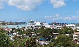
St. John's is the capital and largest city of Antigua and Barbuda, part of the West Indies in the Caribbean Sea. With a population of 22,219, St. John's is the commercial centre of the nation and the chief port of the island of Antigua.
The Antigua and Barbuda national football team is the national team of Antigua and Barbuda.

Antigua, also known as Waladli or Wadadli by the local population, is an island in the Lesser Antilles. It is one of the Leeward Islands in the Caribbean region and the most populous island of the country of Antigua and Barbuda. Antigua and Barbuda became an independent state within the Commonwealth of Nations on 1 November 1981.
The Crossroads Centre is a substance-abuse rehabilitation centre for drug and alcohol addiction located on the Caribbean island of Antigua in Antigua and Barbuda.
Cape Shirley is the southernmost point on the island of Antigua in the nation of Antigua and Barbuda. It is located at 17°0′0″N61°45′0″W between the Caribbean Sea and the Atlantic Ocean.

Signal Hill is a mountain and the second-highest point on Antigua island, in Antigua and Barbuda.
The Shekerley Mountains are a low mountain range on southwestern Antigua island, in the nation of Antigua and Barbuda and the Leeward Islands of the eastern Caribbean.
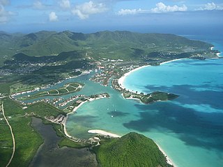
Jolly Harbour is a township on Antigua island, in Antigua and Barbuda.
Potworks Dam is in central Antigua located close to Bethesda. One of the most significant water treatment facilities on the island is located on the southern shore at the Delapps Water Treatment Plant.

Betty's Hope was a sugarcane plantation in Diamonds, Antigua. It was established in 1650, shortly after the island had become an English colony, and flourished as a successful agricultural industrial enterprise during the centuries of slavery. It was the first large-scale sugar plantation to operate in Antigua and belonged to the Codrington family from 1674 until 1944. Christopher Codrington, later Captain General of the Leeward Islands, acquired the property in 1674 and named it Betty's Hope, after his daughter.

Falmouth Harbour is a horseshoe-shaped bay and natural harbour on the far southern coast of the island of Antigua in Antigua and Barbuda.

St. Johnston is a settlement in the northwest of the island of Antigua. It lies to the east of the capital, St. John's, of which is virtually a suburb. Potters Village lies immediately to the southeast. It was named for the Governor General of the Leeward Islands, Sir Thomas Reginald St. Johnston who built a hospital there.

Palmetto Point is a prominent headland that marks the southwesternmost point of the Caribbean island of Barbuda. It lies due south of Codrington Lagoon and separates the west and south coasts of the island. A martello tower stands 2 km to the northeast.

Antigua and Barbuda lie in the eastern arc of the Leeward Islands of the Lesser Antilles, separating the Atlantic Ocean from the Caribbean Sea. Antigua is 650 km (400 mi) southeast of Puerto Rico; Barbuda lies 48 km (30 mi) due north of Antigua, and the uninhabited island of Redonda is 56 km (35 mi) southwest of Antigua.
The Methodist Church in the Caribbean and Americas is a Methodist denomination in Anguilla, Antigua and Barbuda, Aruba, the Bahamas, Barbados, Belize, Bonaire, the British & the US Virgin Islands, the Cayman Islands, Costa Rica, Curaçao, Dominica, Grenada, Guyana, Haiti, Honduras, Jamaica, Panama, Saint Kitts and Nevis, Saint Lucia, Saint Martin, Saint Vincent and the Grenadines, Sint Eustatius, Trinidad and Tobago, and the Turks and Caicos Islands. The Connexion is divided into eight districts:

Dow's Hill Interpretation Centre is a museum on Antigua. The hill was part of the estate of Archibald Dow, a civilian Royal Navy official, before it was acquired for the construction of fortifications. Dow's House became a residence for senior garrison officers and then the Governor of the Leeward Islands before it was destroyed by an 1834 earthquake. The museum was established in 1989 with funding from the Canadian International Development Agency and provides a presentation of Antiguan history and tours of nearby ruins.

The Barbuda Highlands, referred to locally as The Highlands, are a range of hills located on the island of Barbuda in the Caribbean. The highest point in the Barbuda Highlands is 44.5 meters above sea level, and the hills are characterized by rocky outcroppings, scrub vegetation, cacti and a unique ecosystem that includes several species of endemic plants and wildlife. The Barbuda Highlands are a protected area, and are recognized for their environmental and geological significance. The highlands have many caves and are located on the Atlantic Ocean.

Upper Lightfoot is a village in Saint George, Antigua and Barbuda. It had a population of 545 in 2011.