
Anne Arundel County, also notated as AA or A.A. County, is a county located in the U.S. state of Maryland. As of the 2020 United States census, its population was 588,261, an increase of just under 10% since 2010. Its county seat is Annapolis, which is also the capital of the state. The county is named for Anne Arundell, Lady Baltimore, a member of the ancient family of Arundells in Cornwall, England, and the wife of Cecilius Calvert, 2nd Baron Baltimore (1605–1675), founder and first lord proprietor of the colony Province of Maryland. The county is part of the Central Maryland region of the state.

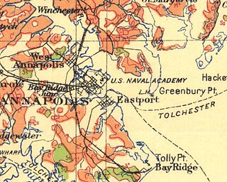
Annapolis is the capital of the U.S. state of Maryland. It is the county seat of Anne Arundel County and its only incorporated city. Situated on the Chesapeake Bay at the mouth of the Severn River, 25 miles (40 km) south of Baltimore and about 30 miles (50 km) east of Washington, D.C., Annapolis forms part of the Baltimore–Washington metropolitan area. The 2020 census recorded its population as 40,812, an increase of 6.3% since 2010.

Arnold, a census-designated place (CDP) in Anne Arundel County, Maryland, United States, located just outside of the state's capital, Annapolis. It is located 18.78 miles south of Baltimore, and 29.97 miles east of Washington, D.C. The population was 23,106 at the 2010 census. Neighborhoods straddle College Parkway and Maryland Route 2. Arnold is located on the scenic Broadneck Peninsula. The ZIP code is 21012. It is bordered by Severna Park to the northwest, Cape Saint Claire to the southeast, Annapolis to the southwest, and Lake Shore to the northeast.

Highland Beach is a town in Anne Arundel County, Maryland, United States. Per the 2020 census, the population was 118. The town was founded late in the 19th century by affluent African Americans from Washington, D.C., and Baltimore, looking for a summer retreat on the Chesapeake Bay. The town's incorporated status gave it a unique standing in empowering it to maintain its own police force. Celebrities with homes there have included historian and author Alex Haley, actor and comedian Bill Cosby, and tennis champion Arthur Ashe. Street names in the town include Crummell, Dunbar, Henson, Augusta, Douglass, Langston, and Washington, which were chosen to honor leading African Americans.

Mayo is a census-designated place (CDP) in Anne Arundel County, Maryland, United States. The population was 8,298 in the 2010 census. The Mayo CDP of 2010 includes all of the area that used to be counted as the Selby-on-the-Bay CDP. The beach in Mayo used to be a popular weekend resort.

Chesapeake Beach is a town in Calvert County, Maryland, United States. Its major attractions include the Chesapeake Beach Railway Station, the Chesapeake Beach Rail Trail, a water park, marinas, piers, and charter boat fishing. The town's population was recorded as 5,753 in the 2010 census.
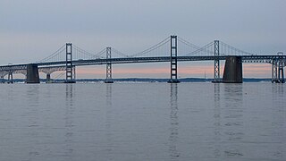
The Gov. William Preston Lane Jr. Memorial Bridge is a major dual-span bridge in the U.S. state of Maryland. Spanning the Chesapeake Bay, it connects the state's rural Eastern Shore region with its urban and suburban Western Shore, running between Stevensville and Sandy Point State Park near the capital city of Annapolis. The original span, opened in 1952 and with a length of 4 miles (6.4 km), was the world's longest continuous over-water steel structure. The parallel span was added in 1973. The bridge is named for William Preston Lane Jr., who as the 52nd Governor of Maryland launched its construction in the late 1940s after decades of political indecision and public controversy.

The Eastern Shore of Maryland is a part of the U.S. state of Maryland that lies mostly on the east side of the Chesapeake Bay. Nine counties are normally included in the region. The Eastern Shore is part of the larger Delmarva Peninsula that Maryland shares with Delaware and Virginia.

Southern Maryland, also referred to as SoMD, is a geographical, cultural and historic region, as well as a National Heritage Area, in Maryland composed of the state's southernmost counties on the Western Shore of the Chesapeake Bay. According to the state of Maryland, the region includes all of Calvert, Charles, and St. Mary's counties and the southern portions of Anne Arundel and Prince George's counties. It is largely coterminous with the region of Maryland that is part of the Washington metropolitan area. Portions of the region are also part of the Baltimore Metropolitan Area and the California-Lexington Park Metropolitan Statistical Area. As of the 2020 Census, the region had a population of 373,177. The largest community in Southern Maryland is Waldorf, with a population of 81,410 as of the 2020 Census.

The Severn River is a tidal estuary 14 miles (23 km) long, located in Anne Arundel County in the U.S. state of Maryland, south of the Magothy River and north of the South River.

Anne Arundel County Public Schools is the public school district serving all of Anne Arundel County, Maryland. With over 85,000 students and 126 schools, the AACPS school system is the 4th largest in Maryland and the 39th largest in the United States. The district has over 5,000 teachers supporting a comprehensive curriculum from Pre-K through 12th grade.
The Bay Ridge and Annapolis Railroad was a 4.5-mile long short line railroad in central Maryland. It ran 4.5 miles from a junction with the Annapolis, Washington and Baltimore Railroad to the resort town of Bay Ridge, Maryland. It mainly provided transportation between Annapolis and the resort, but also connected with a carferry and steamer service to the Eastern Shore. A small connection was eventually made to the Baltimore and Annapolis Short Line. Shortly after opening it fell under the control of the Baltimore and Ohio Railroad. It was never able to make money so it was shut down in 1904 and the tracks were removed in 1918. Almost no sign of it remains today.
Arundel-on-the-Bay is a former post village and resort area in Anne Arundel County, Maryland, United States, located approximately 2 miles (3.2 km) southeast of Annapolis. Arundel-on-the-Bay is located on a peninsula known as the Annapolis Neck and is a peninsula in and of itself, bordered on the east and south by the Chesapeake Bay, and by Fishing Creek on the west.
Beverley Beach is an unincorporated community in Anne Arundel County, Maryland, United States.

Fort Smallwood Park is a county park in northeastern Anne Arundel County, near Riviera Beach and Pasadena, Maryland, United States. It is located on the outer Patapsco River as it meets the Chesapeake Bay, on a peninsula known as Rock Point.
The Broadneck Peninsula is an area in Anne Arundel County, Maryland. The area is north of the Severn River, south of the Magothy River and west of the Chesapeake Bay. At the lower end of the Broadneck Peninsula is the 4.3 mile Chesapeake Bay Bridge.
Jews have settled in Maryland since the 17th century. As of 2018, Maryland's population was 3.9% Jewish at 201,600 people. The largest Jewish populations in Maryland are in Montgomery County, particularly Kemp Mill and Potomac, and the Baltimore metropolitan area, particularly Pikesville and northwest Baltimore. As of 2010, Baltimore and Baltimore County was home to a Jewish community of around 100,000 people. The Maryland suburbs of Washington, D.C. have a Jewish population of around 116,700 as of 2017, with the majority residing in lower Montgomery County. The Rockville/Potomac area is the center of Montgomery County's Jewish population, while sizable communities also exist in the Bethesda/Chevy Chase area and in Silver Spring's Kemp Mill neighborhood. Smaller Jewish communities exist in Gaithersburg, Germantown, White Oak, Olney, and Takoma Park. Columbia, Frederick, Annapolis, Cumberland, and Easton are also home to smaller but significant Jewish populations.
Carr's Beach, founded in 1926, was a beachfront resort on the Chesapeake Bay that catered to African American patrons during segregation.

During the decades of segregation in the United States, African Americans established various resorts. The resorts were self-contained commercial establishments. Varying resort accommodations included rooms for rent, meals and fine food, cocktail bars, dancing, sporting facilities, and beaches. Also in some cases entire communities were known as resort areas for African Americans. The Negro Motorist Green Book helped guide African Americans to accommodating and safe places, including Idlewild, Michigan, which was among the most well known.

