Related Research Articles

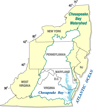
The Chesapeake Bay is the largest estuary in the United States. The Bay is located in the Mid-Atlantic region and is primarily separated from the Atlantic Ocean by the Delmarva Peninsula, including parts of the Eastern Shore of Maryland, the Eastern Shore of Virginia, and the state of Delaware. The mouth of the Bay at its southern point is located between Cape Henry and Cape Charles. With its northern portion in Maryland and the southern part in Virginia, the Chesapeake Bay is a very important feature for the ecology and economy of those two states, as well as others surrounding within its watershed. More than 150 major rivers and streams flow into the Bay's 64,299-square-mile (166,534 km2) drainage basin, which covers parts of six states, New York, Pennsylvania, Delaware, Maryland, Virginia, and West Virginia, and all of Washington, D.C.
The National Estuarine Research Reserve System is a network of 30 protected areas established by partnerships between the National Oceanic and Atmospheric Administration (NOAA) and coastal states. The reserves represent different biogeographic regions of the United States. The National Estuarine Research Reserve System protects more than 1.3 million acres of coastal and estuarine habitats for long-term research, water-quality monitoring, education, and coastal stewardship.

The Anacostia River is a river in the Mid Atlantic region of the United States. It flows from Prince George's County in Maryland into Washington, D.C., where it joins with the Washington Channel and ultimately empties into the Potomac River at Buzzard Point. It is about 8.7 miles (14.0 km) long. The name "Anacostia" derives from the area's early history as Nacotchtank, a settlement of Necostan or Anacostan Native Americans on the banks of the Anacostia River.

The Rappahannock River is a river in eastern Virginia, in the United States, approximately 195 miles (314 km) in length. It traverses the entire northern part of the state, from the Blue Ridge Mountains in the west where it rises, across the Piedmont to the Fall Line, and onward through the coastal plain to flow into the Chesapeake Bay, south of the Potomac River.

Rock Creek is a free-flowing tributary of the Potomac River that empties into the Atlantic Ocean via the Chesapeake Bay. The 32.6-mile (52.5 km) creek drains about 76.5 square miles (198 km2). Its final quarter-mile is affected by tides.

The Monocacy River is a free-flowing left tributary to the Potomac River, which empties into the Atlantic Ocean via the Chesapeake Bay. The river is 58.5 miles (94.1 km) long, with a drainage area of about 970 square miles (2,500 km2). It is the largest Maryland tributary to the Potomac.
The Jordan River is a 12.5-mile-long (20.1 km) headwater tributary of the Rappahannock River in northern Virginia in the United States. It rises in Shenandoah National Park and flows for its entire length in northern Rappahannock County. The river generally flows eastward and joins the Rappahannock River from the west. It is part of the watershed of Chesapeake Bay, via the Rappahannock.

The Hazel River is a 47.8-mile-long (76.9 km) tributary of the Rappahannock River in northern Virginia in the United States. Via the Rappahannock, it is part of the Chesapeake Bay watershed. It rises in Shenandoah National Park and flows generally eastwardly through Rappahannock and Culpeper counties. It joins the Rappahannock River from the west about 3 miles (5 km) northwest of Remington. The Hazel's largest tributaries are the Hughes River, which joins it at the border of Rappahannock and Culpeper counties, and the Thornton River, which joins it in Culpeper County.

Mattawoman Creek is a 30.0-mile-long (48.3 km) coastal-plain tributary to the tidal Potomac River with a mouth at Indian Head, Maryland, 20 miles (32 km) downstream of Washington, D.C. It comprises a 23-mile (37 km) river flowing through Prince George's and Charles counties and a 7-mile (11 km) tidal-freshwater estuary in Charles County. About three-fourths of its 94-square-mile (240 km2) watershed lies in Charles County, with the remainder in Prince George's County immediately to the north.
Rouge National Urban Park is a national urban park in Ontario, Canada. The park is centred around the Rouge River and its tributaries in the Greater Toronto Area. The southern portion of the park is situated around the mouth of the river in Toronto, and extends northwards into Markham, Pickering, Uxbridge, and Whitchurch-Stouffville.
The Sierra Nevada Alliance is a network of conservation groups encompassing 24 watersheds of the 650 kilometer-long Sierra Nevada in California and Nevada. Beginning in 1993, the Alliance protects and restores Sierra Nevada lands, watersheds, wildlife and communities.
The Chesapeake Bay Program is the regional partnership that directs and conducts the restoration of the Chesapeake Bay in the United States. As a partnership, the Chesapeake Bay Program brings together members of various state, federal, academic and local watershed organizations to build and adopt policies that support Chesapeake Bay restoration. By combining the resources and unique strengths of each individual organization, the Chesapeake Bay Program is able to follow a unified plan for restoration. The program office is located in Annapolis, Maryland.

Chiques Creek is a 31.6-mile-long (50.9 km) tributary of the Susquehanna River in Lebanon and Lancaster counties, Pennsylvania in the United States.
The Miles River is a 12.9-mile-long (20.8 km) tidal river in Talbot County, Maryland. It is a tributary of the Eastern Bay and is thus part of the Chesapeake Bay watershed.
Watts Branch is a tributary stream of the Potomac River in Montgomery County, Maryland.

Little Seneca Creek is an 14.0-mile-long (22.5 km) stream in Montgomery County, Maryland, roughly 18 miles (29 km) northwest of Washington, D.C.

Vflo is a commercially available, physics-based distributed hydrologic model generated by Vieux & Associates, Inc. Vflo uses radar rainfall data for hydrologic input to simulate distributed runoff. Vflo employs GIS maps for parameterization via a desktop interface. The model is suited for distributed hydrologic forecasting in post-analysis and in continuous operations. Vflo output is in the form of hydrographs at selected drainage network grids, as well as distributed runoff maps covering the watershed. Model applications include civil infrastructure operations and maintenance, stormwater prediction and emergency management, continuous and short-term surface water runoff, recharge estimation, soil moisture monitoring, land use planning, water quality monitoring, and water resources management.

Tenmile Creek is a tributary stream of Little Seneca Creek in Montgomery County, Maryland.

Lititz Run is a 7.2-mile-long (11.6 km) tributary of the Conestoga River in Lancaster County, Pennsylvania in the United States.
Fones Cliff, is an historic site along the Rappahannock river. It is a sandstone bluff in Richmond County, Virginia.
References
- 1 2 3 4 "Governor Larry Hogan Named "Champion of the Chesapeake" By Chesapeake Conservancy". Office of Governor Larry Hogan. Retrieved 26 April 2018.
- ↑ Brockett, Megan (19 December 2016). "Chesapeake Conservancy announces new board members". Capital Gazette. Retrieved 26 April 2018.
- ↑ "Board of Directors". Chesapeake Conservancy. Retrieved 2021-03-08.
- 1 2 3 4 Saiyid, Amena (4 January 2018). "High-Tech Tools Help Map Chesapeake Bay Restoration". Bloomberg Environment. Retrieved 26 April 2018.
- 1 2 3 4 Brockett, Megan (4 January 2017). "Chesapeake Conservancy mapping ways to strengthen conservation". Capital Gazette. Retrieved 26 April 2018.
- ↑ "Pixel-Level Land Cover Classification Using the Geo AI Data Science Virtual Machine and Batch AI". Microsoft Machine Learning Blog. Microsoft. 12 March 2018. Retrieved 26 April 2018.
- ↑ Pacella, Rachael. "Chesapeake Conservancy gets $1.1 million to bolster mapping data aimed at stormwater cleanup". capitalgazette.com. Retrieved 2019-03-29.
- ↑ "Rappahannock River Property Donated Back to American Indian Tribe". Chesapeake Bay Magazine. 4 December 2017. Archived from the original on 29 April 2018. Retrieved 26 April 2018.
- ↑ "Ecosystem Investment Partners Receives Chesapeake Conservancy's "Champion Of The Chesapeake" Award". Ecosystem Investment Partners. 2018-11-16. Retrieved 2019-03-29.
- ↑ "The Fund Named 2018 "Champion of the Chesapeake"". The Conservation Fund. Archived from the original on 2019-03-29. Retrieved 2019-03-29.
- ↑ "Readiness and Environmental Protection Integration, U.S. Department of Defense". www.repi.mil. Retrieved 2019-03-29.