This article includes a list of references, related reading, or external links, but its sources remain unclear because it lacks inline citations .(April 2010) |
This article includes a list of references, related reading, or external links, but its sources remain unclear because it lacks inline citations .(April 2010) |
Generally, spatial development is linked to include all the techniques used by planners, geographers and other actors of decision making to facilitate integrated balanced development. Spatial planning for development has no territorial barrier, ranging across continents, regions, nations and local communities. Various forms of spatial development qualities have been attributed mainly by the Developed World, while the Developing World and Cameroon in particular, are still trying to integrate the formula into their system. As such, to understand better spatial development in Cameroon, a brief notion of the African context is necessary.
Today, programmes that promotes spatial equity in national development are being given increased attention by international agencies and governments of developing nations, including Cameroon. Industrial expansion within the metropolitan centres is now given the same priority as agricultural policies. However, the inability to build a productive spatial system that integrates urban centres and rural hinterlands into mutual networks of production and exchange has led to a growing number of poor people in the developing nations.
One of the greatest challenges facing Africa today is to upgrade sustainable development in areas where poverty and other economic problems are pronounced. The issue of environmental development needs to be enforced, especially as the world is today speaking the environmental language. It might be surprising to note that, only a few countries in Africa have concrete spatial development plans, most of them situated in the extreme South and North of the continent. Good examples are seen in the Republic of South Africa where there is a development plan at the national level called Spatial Development Initiative (SDI), presently known as, the National Spatial Development Perspective (NSDP). The main aim of these plans is to encourage integrated development within a given space defined by its economic potential rather than by political boundaries. Most of the present day spatial development policies in African countries are linked to their colonial history. That is, development plans mainly in the form of transport and infrastructure were focused along the coast and other sources of raw materials in the hinterlands. This is one of the reasons for spatial inequality in most African countries. Therefore, there is an urgent need for new approaches of spatial development to obtain equity in enhancement.
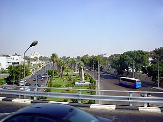
Spatial development in Cameroon dates as far back as the German colonial era. The influence of the Germans through trade and commerce, created a number of trading ports which later became townships. Development plans were purely aimed at export and recruiting areas for soldiers and labourers. Townships whose growth and development could be attributed to this include amongst others, Buea, Kumba, Bamenda, Yaoundé and Douala. Apart from the above policies, the Germans used zoning and racial residential segregation as instruments of land use in the country.
Like the Germans, when the British took over the Western part of Cameroon, they spent no time in establishing growth and development of settlements. Most of the government buildings were on hill tops, overlooking the remote indigenous settlements. Good examples are the GRAs (Government Residential Areas) in Limbe and Buea, and the hilltop station buildings in Bamenda, meant for high class residential only.
History of Cameroon has made it understandable that Cameroon’s experience in spatial planning began in 1966 and span up to 1976 with the introduction of the first and second Five Year Social and Economic Development Plans. The objective was to equitably share the economic resources and fruits of economic progress. The 1961 constitutions placed the spatial planning machinery exclusively into the hands of the Presidency and the National Assembly. In his capacity as the Chief of State of the United Republic of Cameroon, the President had to define the main lines of planning in a Presidential Circular and takes the major decision. On its part, the National Assembly debates and votes on laws to approve the plans.
Planning at the national level was carried out by the Ministry of Planning and Territorial Development. Together with its various departments the ministry was responsible for planning medium and long term development. At the provincial level, the Economic service collected, centralised and handed data to the Governor and the Minister and also organised social development plans at the Provincial Planning Board. At the Divisional level, the Divisional Development Committee was chaired by the Prefect and comprised Mayors, Deputies and private individuals.
Recent spatial planning and development policies in Cameroon are a legacy of its colonial history. Most of the land use plans initiated by the colonial masters have been maintained and strengthened by the country’s planning authorities. This has greatly increased the developmental gap between the colonial townships that are presently urban towns and the rural areas.
Cameroon cannot boast of a real National Spatial Development Plan. Most of the documents emphasising spatial development exist at the regional and local levels but are faced by problems of implementation. The country has a fashionable 'integrated', 'basic need-oriented', 'bottom-up' and 'development-from-within' regional policy programmes. In discussing such a programme and proposing elements of a modified development strategy, it can, however, be argued that even the first step of creating a basic regional development project has been far from satisfactory. Furthermore, in spite of government public speaking, no regional development policy as normally defined exists. What do exist are regional effects of development projects. This prompts the question of whether it may be preferable to replace the term 'regional development policy', with regional 'project policy'.
Ambe J Njoh, 1998. Colonial spatial development policies, economic instability, and urban public transportation in Cameroon. College of Arts and Sciences, University of South Florida
Ambe J Njoh, 1999, The State, urban development policy and society in Cameroon. College of Arts and Sciences, University of South Florida
Denis A. and Kenneth R. 1977. Local Organization for Integrated Rural Development. Implementing Equity Policy in Developing Countries. International Review of Administrative Sciences, Vol.43, No.1, 20-30.
Minang A. (2003) Assessing Participatory Geographic Information System For Community Forest Planning in Cameroon: A Local Governance Perspective. International Institute for Geo-information Science and Earth Observation, Enschede. The Netherlands.
Ndongko.A Regional Economic Planning in Cameroon, Intereconomics, No 5, 1974, pg 154.
Walter H. Rambousek 2002. Regional policy in Cameroon: The case of planning without facts Elsevier Ltd.
Wilfried A. Ndongko (2008) Regional economic planning in Cameroon, Intereconomics, Vol.9, No 5. May 1974, 154-157
Spatial planning mediates between the respective claims on space of the state, market, and community. In so doing, three different mechanisms of involving stakeholders, integrating sectoral policies and promoting development projects mark the three schools of transformative strategy formulation, innovation action and performance in spatial planning

A medina is a historical district in a number of North African cities, often corresponding to an old walled city. The term comes from the Arabic word simply meaning "city" or "town".
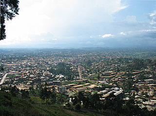
Bamenda, also known as Abakwa and Mankon Town, is a city in northwestern Cameroon and capital of the Northwest Region. The city has a population of about 2 million people and is located 366 km (227 mi) north-west of the Cameroonian capital, Yaoundé. Bamenda is known for its cool climate and scenic hilly location.

Cameroon is a Central African nation on the Gulf of Guinea. Bantu speakers were among the first groups to settle Cameroon, followed by the Muslim Fulani until German domination in 1884. After World War I, the French took over 80% of the area, and the British 20%. After World War II, self-government was granted, and in 1972, a unitary republic was formed out of East and West Cameroon. Until 1976 there were two separate education systems, French and English, which did not merge seamlessly. French is now considered the primary language of instruction. Local languages are generally not taught as there are too many, and choosing between them would raise further issues.
Articles related to Cameroon include:

The Southern Cameroons was the southern part of the British League of Nations mandate territory of the British Cameroons in West Africa. Since 1961, it has been part of the Republic of Cameroon, where it makes up the Northwest Region and Southwest Region. Since 1994, pressure groups in the territory claim there was no legal document in accordance to UNGA RES 1608(XV) paragraph 5, and are seeking to restore statehood and independence from the Republic. They renamed the British Southern Cameroons as Ambazonia.
Integrated coastal zone management (ICZM), integrated coastal management (ICM), or integrated coastal planning is a coastal management process for the management of the coast using an integrated approach, regarding all aspects of the coastal zone, including geographical and political boundaries, in an attempt to achieve sustainability. This concept was born in 1992 during the Earth Summit of Rio de Janeiro. The specifics regarding ICZM is set out in the proceedings of the summit within Agenda 21, Chapter 17.

The following outline is provided as an overview of and topical guide to Cameroon:
Shiba Prasad Chatterjee was a Professor of Geography at the University of Calcutta, India. He served as President of the International Geographical Union from 1964 until 1968, Chatterjee received a Murchison Award from the Royal Geographical Society in 1959, and a Padma Bhushan from the Government of India in 1985. He coined the name 'Meghalaya' for one of India's states.
Cameroon Radio Television (CRTV) is a major radio and television broadcasting company in Cameroon.
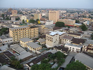
Douala is the largest city in Cameroon and its economic capital. It is also the capital of Cameroon's Littoral Region. Home to Central Africa's largest port and its major international airport, Douala International Airport (DLA), it is the commercial and economic capital of Cameroon and the entire CEMAC region comprising Gabon, Congo, Chad, Equatorial Guinea, Central African Republic and Cameroon. Consequently, it handles most of the country's major exports, such as oil, cocoa and coffee, timber, metals and fruits. As of 2015, the city and its surrounding area had an estimated population of 5,768,400. The city sits on the estuary of Wouri River and its climate is tropical.
The mass media in Cameroon includes independent outlets. The nation has only one national newspaper, which is state owned.
The KNUST Department of Planning (DOP) is one of the academic departments at the Kwame Nkrumah University of Science and Technology in Kumasi, Ghana. It is under the KNUST College of Architecture and Planning. The department offers undergraduate and postgraduate programmes in the award of a degree. It is the only institution in Ghana professionally recognized by its government to train personnel to promote, coordinate and manage development at the national and sub-national levels.

University of Buea (UB) is found in Molyko, Buea, in the southwest region of Cameroon. It was founded as a university centre in 1985 and became a full-fledged university in 1992, following a government decree that re-organized state universities in the country. It is regarded as the best university in Cameroon and is one of two English speaking universities in Cameroon, alongside the University of Bamenda, which follow the British system of education. It serves citizens from both anglophone and francophone regions of Cameroon and from neighboring countries such as Nigeria and Equatorial Guinea.
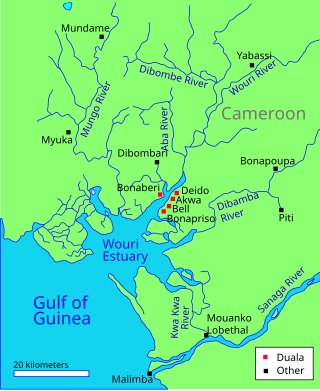
The Wouri estuary, or Cameroon estuary is a large tidal estuary in Cameroon where several rivers come together, emptying into the Bight of Biafra. Douala, the largest city in Cameroon, is at the mouth of the Wouri River where it enters the estuary. The estuary contains extensive mangrove forests, which are being damaged by pollution and population pressures.
The following is a timeline of the history of the city of Douala, Cameroon.
Urban planning in Africa results from indigenous aesthetics and conceptions of form and function as well as the changes brought on by industrialization, modernization, and colonialism. Before the Berlin Conference of 1884 – 1885, which formalized colonialism in many parts of Africa, indigenous African cities and villages had ordered structures that varied along ethnic and religious lines and according to geography. All land-uses necessary for functioning––markets, religious sites, farms, communal assembly spaces––existed in ordered, rational ways, as did land property practices and laws, many of which changed under colonial control. Urbanity changed significantly from pre-colonial to colonial times, as slavery, Christianity, and a host of other forces caused a change in the population of indigenous urban dwellers.

The Cameroon Press Photo Archive (CPPA-B) is a photographic archive located in Buea, the regional capital of the South West Region of Cameroon. It holds around 120,000 negatives and 14,000 proof sheets in total, granting a unique view of Anglophone Cameroon's history for the time period 1955 to 2000. Between 2013 and 2015, African Photography Initiatives digitized 25,000 negatives and all 14,000 proof sheets. A copy of the digitized material is in the possession of the Ministry of Communication, the authority in charge of the photo archive. The CPPA-B is considered an endangered archive.

Glensburg Cities Institute is an urban development think tank of Glensburg that conducts research on urbanisation in Africa.
The Anglophone Crisis, an ongoing civil war between the Cameroonian state and Anglophone separatists who are trying to establish a new state called "Ambazonia", broke out due to grievances which built up within Cameroon at large and its English-speaking parts specifically over several decades.