PostGIS is an open source software program that adds support for geographic objects to the PostgreSQL object-relational database. PostGIS follows the Simple Features for SQL specification from the Open Geospatial Consortium (OGC).
In HTML and XHTML, an image map is a list of coordinates relating to a specific image, created in order to hyperlink areas of the image to different destinations. For example, a map of the world may have each country hyperlinked to further information about that country. The intention of an image map is to provide an easy way of linking various parts of an image without dividing the image into separate image files.
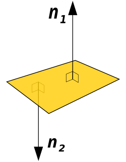
In geometry, a normal is an object such as a line, ray, or vector that is perpendicular to a given object. For example, the normal line to a plane curve at a given point is the (infinite) line perpendicular to the tangent line to the curve at the point. A normal vector may have length one or its length may represent the curvature of the object ; its algebraic sign may indicate sides.

In mathematics, a Voronoi diagram is a partition of a plane into regions close to each of a given set of objects. In the simplest case, these objects are just finitely many points in the plane. For each seed there is a corresponding region, called a Voronoi cell, consisting of all points of the plane closer to that seed than to any other. The Voronoi diagram of a set of points is dual to its Delaunay triangulation.

In mathematics and physics, the centroid or geometric center of a plane figure is the arithmetic mean position of all the points in the figure. Informally, it is the point at which a cutout of the shape could be perfectly balanced on the tip of a pin. The same definition extends to any object in n-dimensional space.

In computer graphics and computational geometry, a bounding volume for a set of objects is a closed volume that completely contains the union of the objects in the set. Bounding volumes are used to improve the efficiency of geometrical operations by using simple volumes to contain more complex objects. Normally, simpler volumes have simpler ways to test for overlap.

R-trees are tree data structures used for spatial access methods, i.e., for indexing multi-dimensional information such as geographical coordinates, rectangles or polygons. The R-tree was proposed by Antonin Guttman in 1984 and has found significant use in both theoretical and applied contexts. A common real-world usage for an R-tree might be to store spatial objects such as restaurant locations or the polygons that typical maps are made of: streets, buildings, outlines of lakes, coastlines, etc. and then find answers quickly to queries such as "Find all museums within 2 km of my current location", "retrieve all road segments within 2 km of my location" or "find the nearest gas station". The R-tree can also accelerate nearest neighbor search for various distance metrics, including great-circle distance.
An R+ tree is a method for looking up data using a location, often coordinates, and often for locations on the surface of the earth. Searching on one number is a solved problem; searching on two or more, and asking for locations that are nearby in both x and y directions, requires craftier algorithms.

In information visualization and computing, treemapping is a method for displaying hierarchical data using nested figures, usually rectangles.
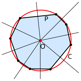
In geometry, the circumscribed circle or circumcircle of a polygon is a circle that passes through all the vertices of the polygon. The center of this circle is called the circumcenter and its radius is called the circumradius.
Simple Features is a set of standards that specify a common storage and access model of geographic feature made of mostly two-dimensional geometries used by geographic information systems. It is formalized by both the Open Geospatial Consortium (OGC) and the International Organization for Standardization (ISO).
A spatial database is a database optimized for storing and querying data that represents objects defined in a geometric space. Most spatial databases allow the representation of simple geometric objects such as points, lines and polygons. Some spatial databases handle more complex structures such as 3D objects, topological coverages, linear networks, and TINs. While typical databases have developed to manage various numeric and character types of data, such databases require additional functionality to process spatial data types efficiently, and developers have often added geometry or feature data types. The Open Geospatial Consortium (OGC) developed the Simple Features specification and sets standards for adding spatial functionality to database systems. The SQL/MM Spatial ISO/IEC standard is a part the SQL/MM multimedia standard and extends the Simple Features standard with data types that support circular interpolations.
Well-known text (WKT) is a text markup language for representing vector geometry objects. A binary equivalent, known as well-known binary (WKB), is used to transfer and store the same information in a more compact form convenient for computer processing but that is not human-readable. The formats were originally defined by the Open Geospatial Consortium (OGC) and described in their Simple Feature Access. The current standard definition is in the ISO/IEC 13249-3:2016 standard.
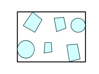
The minimum bounding rectangle (MBR), also known as bounding box (BBOX) or envelope, is an expression of the maximum extents of a 2-dimensional object or set of objects within its 2-D coordinate system, in other words min(x), max(x), min(y), max(y). The MBR is a 2-dimensional case of the minimum bounding box.
SAP SQL Anywhere is a proprietary relational database management system (RDBMS) product from SAP. SQL Anywhere was known as Sybase SQL Anywhere prior to the acquisition of Sybase by SAP.
Hilbert R-tree, an R-tree variant, is an index for multidimensional objects such as lines, regions, 3-D objects, or high-dimensional feature-based parametric objects. It can be thought of as an extension to B+-tree for multidimensional objects.

Two-dimensional space is a geometric setting in which two values are required to determine the position of an element. The set of pairs of real numbers with appropriate structure often serves as the canonical example of a two-dimensional Euclidean space. For a generalization of the concept, see dimension.
The Priority R-tree is a worst-case asymptotically optimal alternative to the spatial tree R-tree. It was first proposed by Arge, De Berg, Haverkort and Yi, K. in an article from 2004. The prioritized R-tree is essentially a hybrid between a k-dimensional tree and a r-tree in that it defines a given object's N-dimensional bounding volume as a point in N-dimensions, represented by the ordered pair of the rectangles. The term prioritized arrives from the introduction of four priority-leaves that represents the most extreme values of each dimensions, included in every branch of the tree. Before answering a window-query by traversing the sub-branches, the prioritized R-tree first checks for overlap in its priority nodes. The sub-branches are traversed by checking whether the least value of the first dimension of the query is above the value of the sub-branches. This gives access to a quick indexation by the value of the first dimension of the bounding box.
