A suburb is an area within a metropolitan area which is predominantly residential and within commuting distance of a large city. Suburbs can have their own political or legal jurisdictions, especially in the United States, but this is not always the case, especially in the United Kingdom, where most suburbs are located within the administrative boundaries of cities. In most English-speaking countries, suburban areas are defined in contrast to central city or inner city areas, but in Australian English and South African English, suburb has become largely synonymous with what is called a "neighborhood" in the U.S. Due in part to historical trends such as white flight, some suburbs in the United States have a higher population and higher incomes than their nearby inner cities.

A ghetto is a part of a city in which members of a minority group are concentrated, especially as a result of political, social, legal, religious, environmental or economic pressure. Ghettos are often known for being more impoverished than other areas of the city. Versions of such restricted areas have been found across the world, each with their own names, classifications, and groupings of people.
William Julius Wilson is an American sociologist, a professor at Harvard University, and an author of works on urban sociology, race, and class issues. Laureate of the National Medal of Science, he served as the 80th President of the American Sociological Association, was a member of numerous national boards and commissions. He identified the importance of neighborhood effects and demonstrated how limited employment opportunities and weakened institutional resources exacerbated poverty within American inner-city neighborhoods.
White flight or white exodus is the sudden or gradual large-scale migration of white people from areas becoming more racially or ethnoculturally diverse. Starting in the 1950s and 1960s, the terms became popular in the United States. They referred to the large-scale migration of people of various European ancestries from racially mixed urban regions to more racially homogeneous suburban or exurban regions. The term has more recently been applied to other migrations by whites, from older, inner suburbs to rural areas, as well as from the American Northeast and Midwest to the milder climate in the Southeast and Southwest. The term 'white flight' has also been used for large-scale post-colonial emigration of whites from Africa, or parts of that continent, driven by levels of violent crime and anti-colonial or anti-white state policies.

Urban sprawl is defined as "the spreading of urban developments on undeveloped land near a city". Urban sprawl has been described as the unrestricted growth in many urban areas of housing, commercial development, and roads over large expanses of land, with little concern for very dense urban planning. Sometimes the urban areas described as the most "sprawling" are the most densely populated. In addition to describing a special form of urbanization, the term also relates to the social and environmental consequences associated with this development. In modern times some suburban areas described as "sprawl" have less detached housing and higher density than the nearby core city. Medieval suburbs suffered from the loss of protection of city walls, before the advent of industrial warfare. Modern disadvantages and costs include increased travel time, transport costs, pollution, and destruction of the countryside. The revenue for building and maintaining urban infrastructure in these areas are gained mostly through property and sales taxes. Most jobs in the US are now located in suburbs generating much of the revenue, although a lack of growth will require higher tax rates.
Geographical segregation exists whenever the proportions of population rates of two or more populations are not homogeneous throughout a defined space. Populations can be considered any plant or animal species, human genders, followers of a certain religion, people of different nationalities, ethnic groups, etc.

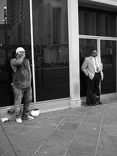
The underclass is the segment of the population that occupies the lowest possible position in a class hierarchy, below the core body of the working class. This group is usually considered cut off from the rest of the society.

Facilities and services such as housing, healthcare, education, employment, and transportation have been systematically separated in the United States based on racial categorizations. Notably, racial segregation in the United States was the legally and/or socially enforced separation of African Americans from whites, as well as the separation of other ethnic minorities from majority and mainstream communities. While mainly referring to the physical separation and provision of separate facilities, it can also refer to other manifestations such as prohibitions against interracial marriage, and the separation of roles within an institution. The U.S. Armed Forces were formally segregated until 1948, as black units were separated from white units but were still typically led by white officers.
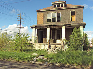
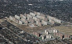
Shrinking cities or urban depopulation are dense cities that have experienced a notable population loss. Emigration is a common reason for city shrinkage. Since the infrastructure of such cities was built to support a larger population, its maintenance can become a serious concern. A related phenomenon is counterurbanization.

In the context of the 20th-century history of the United States, the Second Great Migration was the migration of more than 5 million African Americans from the South to the Northeast, Midwest and West. It began in 1940, through World War II, and lasted until 1970. It was much larger and of a different character than the first Great Migration (1916–1940), where the migrants were mainly rural farmers from the South and only came to the Northeast and Midwest.
An ethnoburb is a suburban residential and business area with a notable cluster of a particular ethnic minority population, which may or may not be a local majority. That can greatly influence the social geography within the area because of distinct cultural and religious values. Ethnoburbs allow for ethnic minority groups to maintain their traditional identity, forestalling cultural assimilation.
Social apartheid is de facto segregation on the basis of class or economic status, in which an underclass is forced to exist separated from the rest of the population.
African-American neighborhoods or black neighborhoods are types of ethnic enclaves found in many cities in the United States. Generally, an African American neighborhood is one where the majority of the people who live there are African American. Some of the earliest African-American neighborhoods were in New Orleans, Mobile, Atlanta, and other cities throughout the American South, as well as in New York City. In 1830, there were 14,000 "Free negroes" living in New York City.
Economic restructuring is used to indicate changes in the constituent parts of an economy in a very general sense. In the western world, it is usually used to refer to the phenomenon of urban areas shifting from a manufacturing to a service sector economic base. It has profound implications for productive capacities and competitiveness of cities and regions. This transformation has affected demographics including income distribution, employment, and social hierarchy; institutional arrangements including the growth of the corporate complex, specialized producer services, capital mobility, informal economy, nonstandard work, and public outlays; as well as geographic spacing including the rise of world cities, spatial mismatch, and metropolitan growth differentials.
Residential segregation is the physical separation of two or more groups into different neighborhoods—a form of segregation that "sorts population groups into various neighborhood contexts and shapes the living environment at the neighborhood level". While it has traditionally been associated with racial segregation, it generally refers to the separation of populations based on some criteria.
In the United States, housing segregation is the practice of denying African Americans and other minority groups equal access to housing through the process of misinformation, denial of realty and financing services, and racial steering. Housing policy in the United States has influenced housing segregation trends throughout history. Key legislation include the National Housing Act of 1934, the G.I. Bill, and the Fair Housing Act. Factors such as socioeconomic status, spatial assimilation, and immigration contribute to perpetuating housing segregation. The effects of housing segregation include relocation, unequal living standards, and poverty. However, there have been initiatives to combat housing segregation, such as the Section 8 housing program.

Concentrated poverty concerns the spatial distribution of socio-economic deprivation, specifically focusing on the density of poor populations. Within the United States, common usage of the term concentrated poverty is observed in the fields of policy and scholarship referencing areas of "extreme" or "high-poverty." These are defined by the US census as areas where "40 percent of the tract population [lives] below the federal poverty threshold." A large body of literature argues that areas of concentrated poverty place additional burdens on poor families residing within them, burdens beyond what these families' individual circumstances would dictate. Research also indicates that areas of concentrated poverty can have effects beyond the neighborhood in question, affecting surrounding neighborhoods not classified as "high-poverty" and subsequently limiting their overall economic potential and social cohesion. Concentrated poverty is a global phenomenon, with prominent examples world-wide. Despite differing definitions, contributing factors, and overall effects, global concentrated poverty retains its central theme of spatial density. Multiple programs have attempted to ameliorate concentrated poverty and its effects within the United States, with varying degrees of progress and to sometimes detrimental effect.
Structural inequality occurs when the fabric of organizations, institutions, governments or social networks contains an embedded cultural, linguistic, economic, religious/belief, physical or identity based bias which provides advantages for some members and marginalizes or produces disadvantages for other members. This can involve, personal agency, freedom of expression, property rights, freedom of association, religious freedom, social status, or unequal access to health care, housing, education, physical, cultural, social, religious or political belief, financial resources or other social opportunities. Structural inequality is believed to be an embedded part of all known cultural groups. The global history of slavery, serfdom, indentured servitude and other forms of coerced cultural or government mandated labour or economic exploitation that marginalizes individuals and the subsequent suppression of human rights are key factors defining structural inequality.
John Forrest Kain was an American empirical economist and college professor. He is notable for first hypothesising spatial mismatch theory, whereby he argued that there are insufficient job opportunities in low-income household areas. Kain is also notable for his focus on transport economics, for his long career of teaching at Harvard University and the University of Texas at Dallas, as well as for founding the Texas Schools Project.
Yves Zenou is a French-Swedish-Australian economist. He is a professor at Monash University and holds the Richard Snape Chair in Business and Economics.