
Surveillance aircraft are aircraft used for surveillance. They are primarily operated by military forces and government agencies in roles including intelligence gathering, maritime patrol, battlefield and airspace surveillance, observation, and law enforcement.

A reconnaissance satellite or intelligence satellite is an Earth observation satellite or communications satellite deployed for military or intelligence applications.

Titan was a family of United States expendable rockets used between 1959 and 2005. The Titan I and Titan II were part of the US Air Force's intercontinental ballistic missile (ICBM) fleet until 1987. The space launch vehicle versions contributed the majority of the 368 Titan launches, including all the Project Gemini crewed flights of the mid-1960s. Titan vehicles were also used to lift US military payloads as well as civilian agency reconnaissance satellites and to send interplanetary scientific probes throughout the Solar System.
Electromagnetic warfare or electronic warfare (EW) is warfare involving the use of the electromagnetic spectrum or directed energy to control the spectrum, attack an enemy, or impede enemy operations. The purpose of electromagnetic warfare is to deny the opponent the advantage of—and ensure friendly unimpeded access to—the EM spectrum. Electromagnetic warfare can be applied from air, sea, land, or space by crewed and uncrewed systems, and can target communication, radar, or other military and civilian assets.

In military operations, military reconnaissance or scouting is the exploration of an area by military forces to obtain information about enemy forces, the terrain, and civil activities in the area of operations. In military jargon, reconnaissance is abbreviated to recce and to recon, both derived from the root word reconnoitre / reconnoitering.

Imagery intelligence (IMINT), pronounced as either as Im-Int or I-Mint, is an intelligence gathering discipline wherein imagery is analyzed to identify information of intelligence value. Imagery used for defense intelligence purposes is generally collected via satellite imagery or aerial photography.

The Corona program was a series of American strategic reconnaissance satellites produced and operated by the Central Intelligence Agency (CIA) Directorate of Science & Technology with substantial assistance from the U.S. Air Force. The CORONA satellites were used for photographic surveillance of the Soviet Union (USSR), China, and other areas beginning in June 1959 and ending in May 1972.

The National Reconnaissance Office (NRO) is a member of the United States Intelligence Community and an agency of the United States Department of Defense which designs, builds, launches, and operates the reconnaissance satellites of the U.S. federal government. It provides satellite intelligence to several government agencies, particularly signals intelligence (SIGINT) to the National Security Agency (NSA), imagery intelligence (IMINT) to the National Geospatial-Intelligence Agency (NGA), and measurement and signature intelligence (MASINT) to the Defense Intelligence Agency (DIA). The NRO announced in 2023 that it plans within the following decade to quadruple the number of satellites it operates and increase the number of signals and images it delivers by a factor of ten.

The Satellite Data System (SDS) is a system of United States military communications satellites. At least three generations have been used: SDS-1 from 1976 to 1987; SDS-2 from 1989 to 1996; SDS-3 from 1998 to the present. It is believed that these satellites were known by the code name Quasar. The first generation was named simply 'SDS', the second generation was named 'Quasar' and the third generation each had their own designations.

ISTAR stands for intelligence, surveillance, target acquisition, and reconnaissance. In its macroscopic sense, ISTAR is a practice that links several battlefield functions together to assist a combat force in employing its sensors and managing the information they gather.

A military satellite is an artificial satellite used for a military purpose. The most common missions are intelligence gathering, navigation and military communications.

Lacrosse or Onyx was a series of terrestrial radar imaging reconnaissance satellites operated by the United States National Reconnaissance Office (NRO). While not officially confirmed by the NRO or the Government of the United States prior to 2008, there was widespread evidence pointing to its existence, including one NASA website. In July 2008, the NRO itself declassified the existence of its synthetic aperture radar (SAR) satellite constellation.

The militarisation of space involves the placement and development of weaponry and military technology in outer space. The early exploration of space in the mid-20th century had, in part, a military motivation, as the United States and the Soviet Union used it as an opportunity to demonstrate ballistic-missile technology and other technologies having the potential for military application. Outer space has since been used as an operating location for military spacecraft such as imaging and communications satellites, and some ballistic missiles pass through outer space during their flight. As of 2018, known deployments of weapons stationed in space include only the Almaz space-station armament and pistols such as the TP-82 Cosmonaut survival pistol.
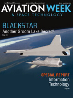
Blackstar is the reported code-name of a secret United States orbital spaceplane system. The possible existence of the Blackstar program was reported in March 2006 by Aviation Week & Space Technology magazine; the magazine reported that the program had been underway since at least the early 1990s, and that the impetus for Blackstar was to allow the United States government to retain orbital reconnaissance capabilities jeopardized following the 1986 Challenger disaster. The article also said that the United States Air Force's Space Command was unaware of Blackstar, suggesting it was operated by an intelligence agency such as the National Reconnaissance Office.

The Naval Information Warfare Systems Command (NAVWAR), based in San Diego, California, is one of six SYSCOM Echelon II organizations within the United States Navy and is the Navy's technical authority and acquisition command for C4ISR, business information technology and space systems. Echelon II means that the organization reports to someone who, in turn, reports directly to the Chief of Naval Operations on the military side. From a civilian perspective, NAVWAR reports to the Assistant Secretary of the Navy (RDA). The command was formerly known as Space and Naval Warfare Systems Command (SPAWAR) and was renamed in June 2019 to better align its identity with its mission.
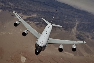
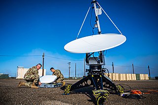
Signals intelligence operational platforms are employed by nations to collect signals intelligence, which is intelligence-gathering by interception of signals, whether between people or between machines, or mixtures of the two. As sensitive information is often encrypted, signals intelligence often involves the use of cryptanalysis. However, traffic analysis—the study of who is signalling whom and in what quantity—can often produce valuable information, even when the messages themselves cannot be decrypted.

Aerospace Data Facility-East (ADF-E), also known as Area 58 and formerly known as Defense Communications Electronics Evaluation and Testing Activity (DCEETA), is one of three satellite ground stations operated by the National Reconnaissance Office (NRO) in the continental United States. Located within Fort Belvoir, Virginia, the facility is responsible for the command and control of reconnaissance satellites involved in the collection of intelligence information and for the dissemination of that intelligence to other U.S. government agencies.

Project SAINT was a project undertaken by the United States during the Cold War to develop a means of intercepting, inspecting and destroying Soviet spacecraft. Many details relating to the project are still classified. The order to launch the SAINT could only be given by the NORAD commander-in-chief, and presumably, anyone higher ranked than them.

The United States Space Force (USSF) is the United States Armed Forces' space service and one of the eight uniformed services of the United States. It is one of two independent space forces in the world.
While the United States Space Force gained its independence on 20 December 2019, the history of the United States Space Force can be traced back to the beginnings of the military space program following the conclusion of the Second World War in 1945. Early military space development was begun within the United States Army Air Forces by General Henry H. Arnold, who identified space as a crucial military arena decades before the first spaceflight. Gaining its independence from the Army on 18 September 1947, the United States Air Force began development of military space and ballistic missile programs, while also competing with the United States Army and United States Navy for the space mission.