Reconnaissance satellite

Last updated

A list of the types of U.S. reconnaissance satellites deployed from 1960 onward U.S. RecSat Big Picture.jpg
A list of the types of U.S. reconnaissance satellites deployed from 1960 onward
Aerial view of Osama bin Laden's compound in the Pakistani city of Abbottabad made by the CIA. CIA aerial view Osama bin Laden compound Abbottabad.jpg
Aerial view of Osama bin Laden's compound in the Pakistani city of Abbottabad made by the CIA.
KH-4B Corona satellite Kh-4b corona.jpg
KH-4B Corona satellite
U.S. Lacrosse radar spy satellite under construction Lacrosse sat.jpg
U.S. Lacrosse radar spy satellite under construction
A model of a German SAR-Lupe reconnaissance satellite inside a Cosmos-3M rocket. SAR-Lupe.jpg
A model of a German SAR-Lupe reconnaissance satellite inside a Cosmos-3M rocket.
Microwave interception (Rhyolite) Rhyolite sat.svg
Microwave interception (Rhyolite)

A reconnaissance satellite or intelligence satellite (commonly, although unofficially, referred to as a spy satellite) is an Earth observation satellite or communications satellite deployed for military or intelligence applications.

Contents

The first generation type (i.e., Corona [1] [2] and Zenit) took photographs, then ejected canisters of photographic film which would descend back down into Earth's atmosphere. Corona capsules were retrieved in mid-air as they floated down on parachutes. Later, spacecraft had digital imaging systems and downloaded the images via encrypted radio links.

In the United States, most information available about reconnaissance satellites is on programs that existed up to 1972, as this information has been declassified due to its age. Some information about programs before that time is still classified information, and a small amount of information is available on subsequent missions.

A few up-to-date reconnaissance satellite images have been declassified on occasion, or leaked, as in the case of KH-11 photographs which were sent to Jane's Defence Weekly in 1984, [3] or US President Donald Trump tweeting a classified image of the aftermath of a failed test of Iran's Safir rocket in 2019. [4] [5]

History

On 16 March 1955, the United States Air Force officially ordered the development of an advanced reconnaissance satellite to provide continuous surveillance of "preselected areas of the Earth" in order "to determine the status of a potential enemy’s war-making capability". [6]

During the mid-late 1950s, both the United States and the Soviet Union took interest into reconnaissance satellites. The United States began the CORONA project, which encompassed several series of launches starting in 1959 and ending in 72. This program was made a priority to photograph denied areas, replace the U-2, and due to public concern about a technological gap between the West and the Soviet Union. [7] [8] It was expedited significantly after the shooting of a U-2 in 1960. [9]

Meanwhile, in the Soviet Union, a decree that authorized the development of sputnik apparently authorized a program for a satellite to be used for photo reconnaissance. This design evolved into Vostok, while another version became Zenit, which was an unmanned reconnaissance satellite. Zenit was launched from 1961 to 1994, however the last flight in 1994 was as a test payload.

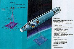
Both the CORONA and Zenit satellites had to be recovered and used film, making them distinct from future reconnaissance satellites that could transmit photos without returning film to earth. [10] [11]

Types

There are several major types of reconnaissance satellite. [12]

Missile early warning
Provides warning of an attack by detecting ballistic missile launches. Earliest known are Missile Defense Alarm System.[ citation needed ]
Nuclear explosion detection
Detects nuclear detonation from space. Vela is the earliest known.[ citation needed ]
Electronic reconnaissance
Signals intelligence, intercepts stray radio waves. SOLRAD is the earliest known. [13]
Optical imaging surveillance
Earth imaging satellites. Satellite images can be a survey or close-look telephoto. Corona is the earliest known. Spectral imaging is commonplace.
Radar imaging surveillance
Most space-based radars use synthetic-aperture radar.[ citation needed ] Can be used at night or through cloud cover. Earliest known are the Soviet US-A series.

Missions

Examples of reconnaissance satellite missions:

On 28 August 2013, it was thought that "a $1-billion high-powered spy satellite capable of snapping pictures detailed enough to distinguish the make and model of an automobile hundreds of miles below" [14] was launched from California's Vandenberg Air Force Base using a Delta IV Heavy launcher, America's highest-payload space launch vehicle at the time.

On 17 February 2014, a Russian Kosmos-1220 originally launched in 1980 and used for naval missile targeting until 1982, made an uncontrolled atmospheric entry. [15]

Benefits

During the 1950s, a Soviet hoax had led to American fears of a bomber gap. In 1968, after gaining satellite photography, the United States' intelligence agencies were able to state with certainty that "No new ICBM complexes have been established in the USSR during the past year". President Lyndon B. Johnson told a gathering in 1967: [16]

I wouldn't want to be quoted on this ... We've spent $35 or $40 billion on the space program. And if nothing else had come out of it except the knowledge that we gained from space photography, it would be worth ten times what the whole program has cost. Because tonight we know how many missiles the enemy has and, it turned out, our guesses were way off. We were doing things we didn't need to do. We were building things we didn't need to build. We were harboring fears we didn't need to harbor.

During his 1980 State of the Union Address, President Jimmy Carter argued that all of humanity benefited from the presence of American spy satellites: [17]

...photo-reconnaissance satellites, for example, are enormously important in stabilizing world affairs and thereby make a significant contribution to the security of all nations.

Reconnaissance satellites have been used to enforce human rights, through the Satellite Sentinel Project, which monitors atrocities in Sudan and South Sudan.

Additionally, companies such as GeoEye and DigitalGlobe have provided commercial satellite imagery in support of natural disaster response and humanitarian missions. [18]

In fiction

Spy satellites are commonly seen in spy fiction and military fiction. Some works of fiction that focus specifically on spy satellites include:

See also

Related Research Articles

<span class="mw-page-title-main">Imagery intelligence</span> Intelligence gathered by means of imagery

Imagery intelligence (IMINT), pronounced as either as Im-Int or I-Mint, is an intelligence gathering discipline wherein imagery is analyzed to identify information of intelligence value. Imagery used for defense intelligence purposes is generally collected via satellite imagery or aerial photography.

<span class="mw-page-title-main">Cold War espionage</span> Aspect of the Cold War

Cold War espionage describes the intelligence gathering activities during the Cold War between the Western allies and the Eastern Bloc. Both relied on a wide variety of military and civilian agencies in this pursuit.

<span class="mw-page-title-main">CORONA (satellite)</span> American reconnaissance satellites (1959–1972)

The Corona program was a series of American strategic reconnaissance satellites produced and operated by the Central Intelligence Agency (CIA) Directorate of Science & Technology with substantial assistance from the U.S. Air Force. The CORONA satellites were used for photographic surveillance of the Soviet Union (USSR), China, and other areas beginning in June 1959 and ending in May 1972.

<span class="mw-page-title-main">National Reconnaissance Office</span> US intelligence agency in charge of satellite intelligence

The National Reconnaissance Office (NRO) is a member of the United States Intelligence Community and an agency of the United States Department of Defense which designs, builds, launches, and operates the reconnaissance satellites of the U.S. federal government. It provides satellite intelligence to several government agencies, particularly signals intelligence (SIGINT) to the NSA, imagery intelligence (IMINT) to the NGA, and measurement and signature intelligence (MASINT) to the DIA. The NRO announced in 2023 that it plans within the following decade to quadruple the number of satellites it operates and increase the number of signals and images it delivers by a factor of ten.

<span class="mw-page-title-main">KH-7 Gambit</span> Series of United States reconnaissance satellites

BYEMAN codenamed GAMBIT, the KH-7 was a reconnaissance satellite used by the United States from July 1963 to June 1967. Like the older CORONA system, it acquired imagery intelligence by taking photographs and returning the undeveloped film to earth. It achieved a typical ground-resolution of 2 ft (0.61 m) to 3 ft (0.91 m). Though most of the imagery from the KH-7 satellites was declassified in 2002, details of the satellite program remained classified until 2011.

<span class="mw-page-title-main">KH-8 Gambit 3</span> Series of United States reconnaissance satellites

The KH-8 was a long-lived series of reconnaissance satellites of the "Key Hole" (KH) series used by the United States from July 1966 to April 1984, and also known as Low Altitude Surveillance Platform. The satellite ejected "film-bucket" canisters of photographic film that were retrieved as they descended through the atmosphere by parachute. Ground resolution of the mature satellite system was better than 4 inches (0.10 m). There were 54 launch attempts of the 3,000 kilogram satellites, all from Vandenberg Air Force Base, on variants of the Titan III rocket. Three launches failed to achieve orbit. The first one was satellite #5 on April 26, 1967, which fell into the Pacific Ocean after the Titan second stage developed low thrust. The second was satellite #35 on May 20, 1972, which suffered an Agena pneumatic regulator failure and reentered the atmosphere. A few months later, pieces of the satellite turned up in England and the US managed to arrange for their hasty return. The third failure was satellite #39 on June 26, 1973, which suffered a stuck Agena fuel valve. The Bell 8096 engine failed to start and the satellite burned up in the atmosphere. The KH-8 was manufactured by Lockheed. The camera system/satellite was manufactured by Eastman Kodak's A&O Division in Rochester, New York.

<span class="mw-page-title-main">Samos (satellite)</span> Series of reconnaissance satellites for the United States

The SAMOS or SAMOS-E program was a relatively short-lived series of reconnaissance satellites for the United States in the early 1960s, also used as a cover for the initial development of the KH-7 GAMBIT system. Reconnaissance was performed with film cameras and television surveillance from polar low Earth orbits with film canister returns and transmittals over the United States. SAMOS was first launched in 1960 from Vandenberg Air Force Base.

<span class="mw-page-title-main">Military satellite</span> Artificial satellite used for military purposes

A military satellite is an artificial satellite used for a military purpose. The most common missions are intelligence gathering, navigation and military communications.

Lockheed Martin Space is one of the four major business divisions of Lockheed Martin. It has its headquarters in Littleton, Colorado, with additional sites in Valley Forge, Pennsylvania; Sunnyvale, California; Santa Cruz, California; Huntsville, Alabama; and elsewhere in the United States and United Kingdom. The division currently employs about 20,000 people, and its most notable products are commercial and military satellites, space probes, missile defense systems, NASA's Orion spacecraft, and the Space Shuttle external tank.

<span class="mw-page-title-main">Galactic Radiation and Background</span> First US orbital surveillance program

Galactic Radiation and Background (GRAB) was the first successful United States orbital surveillance program, comprising a series of five Naval Research Laboratory electronic surveillance and solar astronomy satellites, launched from 1960 to 1962. Though only two of the five satellites made it into orbit, they returned a wealth of information on Soviet air defense radar capabilities as well as useful astronomical observations of the Sun.

<span class="mw-page-title-main">Future Imagery Architecture</span> American spy satellite program

Future Imagery Architecture (FIA) was a program awarded to Boeing to design a new generation of optical and radar imaging US reconnaissance satellites for the National Reconnaissance Office (NRO). In 2005 NRO director Donald Kerr recommended the project's termination, and the optical component of the program was finally cancelled in September 2005 by Director of National Intelligence John Negroponte. FIA has been called by The New York Times "perhaps the most spectacular and expensive failure in the 50-year history of American spy satellite projects." Despite the optical component's cancellation, the radar component, known as Topaz, has continued, with four satellites in orbit as of February 2016.

Thor was a US space launch vehicle derived from the PGM-17 Thor intermediate-range ballistic missile. The Thor rocket was the first member of the Delta rocket family of space launch vehicles. The last launch of a direct derivative of the Thor missile occurred in 2018 as the first stage of the final Delta II.

<span class="mw-page-title-main">KH-9 Hexagon</span> American family of spy satellites

KH-9, commonly known as Big Bird or KeyHole-9, was a series of photographic reconnaissance satellites launched by the United States between 1971 and 1986. Of twenty launch attempts by the National Reconnaissance Office, all but one were successful. Photographic film aboard the KH-9 was stored on RCA Astro Electronic Division take up reel system then sent back to Earth in recoverable film return capsules for processing and interpretation. The highest ground resolution achieved by the main cameras of the satellite was 2 ft (0.61 m), though another source says "images in the "better-than-one-foot" category" for the last "Gambit" missions.

<span class="mw-page-title-main">Dino Brugioni</span> American intelligence analyst

Dino Antonio Brugioni was a former senior official at the CIA's National Photographic Interpretation Center (NPIC). He was an imagery analyst and also served as NPIC's Chief of Information. During his 35-year career, Brugioni helped establish imagery intelligence (IMINT) as a national asset to solve intelligence problems. Even after retirement, Brugioni was considered to be the world's foremost imagery intelligence analyst.

<span class="mw-page-title-main">Discoverer 1</span> American reconnaissance satellite launched in 1959; failed to achieve orbit

Discoverer 1 was the first of a series of satellites which were part of the CORONA reconnaissance satellite program. It was launched on a Thor-Agena A rocket on 28 February 1959 at 21:49:16 GMT from Vandenberg Air Force Base in California. It was a prototype of the KH-1 satellite, but did not contain either a camera or a film capsule. It was the first satellite launched toward the South Pole in an attempt to achieve a polar orbit, but was unsuccessful. A CIA report, later declassified, concluded that "Today, most people believe the Discoverer 1 landed somewhere near the South Pole".

<span class="mw-page-title-main">Discoverer 14</span> American reconnaissance satellite

Discoverer 14, also known as Corona 9009, was a spy satellite used in the Corona program managed by Advanced Research Projects Agency (ARPA) of the Department of Defense and the United States Air Force. On 19 August 1960, usable photographic film images of the Soviet Union taken by the satellite were recovered by a C-119 recovery aircraft. This was the first successful recovery of film from an orbiting satellite and the first mid-air recovery of an object returning from Earth orbit.

<span class="mw-page-title-main">Discoverer 4</span> American reconnaissance satellite

Discoverer 4, also known as Corona 9001, was an American optical reconnaissance satellite launched on 25 Jun 1959 at 22:47:45 GMT, the first of ten operational flights of the Corona KH-1 spy satellite series, and the first satellite to be equipped for photo surveillance. The satellite was not successfully orbited. Its loss spurred improvements of its rocket booster to ensure the success of subsequent missions.

<span class="mw-page-title-main">Discoverer 2</span> American reconnaissance satellite

Discoverer 2 was an American optical reconnaissance satellite launched on 13 April 1959 at 21:18:39 GMT, the second of three test flights of the Corona KH-1 spy satellite series. Discoverer 2 was the first satellite to be stabilized in orbit in all three axes and to be maneuvered on command from the earth. Though it carried no film and thus conducted no surveillance, Discoverer 2 was both the first satellite equipped with a reentry capsule and the first to return a payload from orbit. A timing error caused the reentry capsule to land near the island of Spitzbergen, Norway, rather than Hawaii. A joint US-Norway recovery operation was mounted, but was unsuccessful, and there was fear that the capsule ended in the possession of the Soviet Union. Such claims have never been verified. The flight and loss of Discoverer 2 was the inspiration for the book and film Ice Station Zebra.

<span class="mw-page-title-main">Discoverer 12</span> Reconnaissance satellite

Discoverer 12 was an American optical reconnaissance satellite launched on 29 June 1960, at 22:00:44 GMT. The fourth of five test flights of the Corona KH-1 spy satellite series was lost when the second stage failed during launch.

<span class="mw-page-title-main">Discoverer 15</span> Reconnaissance satellite of the United States Air Force

Discoverer 15, also known as Corona 9010, was a spy satellite used in the Corona program managed by Advanced Research Projects Agency (ARPA) of the Department of Defense and the United States Air Force. Launched on 13 September 1960, the satellite took reconnaissance photos of the Soviet Union. However, its recoverable film capsule was lost in the Pacific Ocean after reentry outside the recovery zone on 15 September.

References

  1. "Corona History". National Reconnaissance Office]. Archived from the original on 22 February 2014. Retrieved 15 February 2014.
  2. "Corona Program". Mission and Spacecraft Library. Archived from the original on 7 August 2011. Retrieved 16 February 2014.
  3. Wright, Michael; Herron, Caroline Rand (8 December 1985). "Two Years for Morison". The New York Times . Retrieved 16 February 2014.
  4. Brumfiel, Geoff (30 August 2019). "Trump Tweets Sensitive Surveillance Image of Iran". NPR. Retrieved 1 September 2019.
  5. Oberhaus, Daniel (3 September 2019). "Trump Tweeted a Sensitive Photo. Internet Sleuths Decoded It". Wired (San Francisco, Calif.). Wired. ISSN   1059-1028.
  6. Erickson, Mark (2005). Into the Unknown Together – The DOD, NASA, and Early Spaceflight (PDF). Air University Press. ISBN   1-58566-140-6. Archived from the original (PDF) on 20 September 2009.
  7. "Sputnik launched — History.com This Day in History — 10/4/1957". 7 March 2010. Archived from the original on 7 March 2010. Retrieved 15 May 2024.
  8. Angelo, Joseph A. (14 May 2014). Encyclopedia of Space and Astronomy. Infobase. p. 489. ISBN 9781438110189
  9. PD-icon.svg This article incorporates text from this source, which is in the public domain :United States; Central Intelligence Agency; Ruffner, Kevin Conley (1995). CORONA America's first satellite program. Center for the Study of Intelligence, Central Intelligence Agency. p. xiii. OCLC   42006243.
  10. Gorin, Peter (1997). "Zenit:Corona's Soviet Counterpart". In Robert A McDonald (ed.). Corona Between the Sun and the Earth: the first NRO reconnaissance eye in space. Bethesda, MD: The American Society for Photogrammetry and Remote Sensing. pp. 84–107.
  11. PD-icon.svg This article incorporates text from this source, which is in the public domain : "Discoverer 1". NASA. 14 May 2020. Retrieved 5 January 2021.
  12. reconnaissance satellite, Infoplease, retrieved 17 February 2014
  13. "The Navy's Spy Missions in Space". U.S. Naval Research Laboratory. April 2008. Archived from the original on 21 April 2019. Retrieved 21 April 2019.PD-icon.svg This article incorporates text from this source, which is in the public domain .
  14. Hennigan, W.J. (27 August 2013). "Monster rocket to blast off from Pacific coast, rattle Southland". Los Angeles Times . Retrieved 16 February 2014.
  15. Melissa Goldin (17 February 2014). "Fragments of Soviet-Era Satellite Burn Up in Earth's Atmosphere". Mashable . Retrieved 17 February 2014.
  16. Heppenheimer, T. A. (1998). The Space Shuttle Decision. NASA. pp. 191, 198.
  17. "The State of the Union Annual Message to the Congress". 1980 State of the Union Address. The American Presidency Project. Retrieved 11 April 2014.
  18. "Commercial Satellite Imagery Companies Partner with the U.S. Geological Survey in Support of the International Charter "Space and Major Disasters"". USGS Newsroom. United States Geological Survey . Retrieved 4 April 2014.

Further reading