
The Geostationary Operational Environmental Satellite (GOES), operated by the United States' National Oceanic and Atmospheric Administration (NOAA)'s National Environmental Satellite, Data, and Information Service division, supports weather forecasting, severe storm tracking, and meteorology research. Spacecraft and ground-based elements of the system work together to provide a continuous stream of environmental data. The National Weather Service (NWS) and the Meteorological Service of Canada use the GOES system for their North American weather monitoring and forecasting operations, and scientific researchers use the data to better understand land, atmosphere, ocean, and climate dynamics.

A weather satellite or meteorological satellite is a type of Earth observation satellite that is primarily used to monitor the weather and climate of the Earth. Satellites can be polar orbiting, or geostationary.

Mars 96 was a failed Mars mission launched in 1996 to investigate Mars by the Russian Space Forces and not directly related to the Soviet Mars probe program of the same name. After failure of the second fourth-stage burn, the probe assembly re-entered the Earth's atmosphere, breaking up over a 320 km (200 mi) long portion of the Pacific Ocean, Chile, and Bolivia. The Mars 96 spacecraft was based on the Phobos probes launched to Mars in 1988. They were of a new design at the time and both ultimately failed. For the Mars 96 mission the designers believed they had corrected the flaws of the Phobos probes, but the value of their improvements was never demonstrated due to the destruction of the probe during the launch phase.

Terra is a multi-national, NASA scientific research satellite in a Sun-synchronous orbit around the Earth that takes simultaneous measurements of Earth’s atmosphere, land, and water to understand how Earth is changing and to identify the consequences for life on Earth. It is the flagship of the Earth Observing System (EOS) and the first satellite of the system which was followed by Aqua and Aura. Terra was launched in 1999.
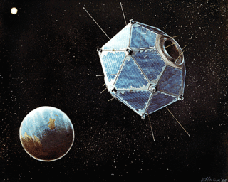
Vela was the name of a group of satellites developed as the Vela Hotel element of Project Vela by the United States to detect nuclear detonations to monitor compliance with the 1963 Partial Test Ban Treaty by the Soviet Union.
Project Vela was a project undertaken by the United States Department of Defense to develop and implement methods to monitor compliance with the 1963 Partial Test Ban Treaty. This treaty banned the testing of nuclear weapons in the atmosphere, in outer space, and underwater, effectively meaning nuclear tests were only to be permitted underground.

Satellite images are images of Earth collected by imaging satellites operated by governments and businesses around the world. Satellite imaging companies sell images by licensing them to governments and businesses such as Apple Maps and Google Maps.
A bhangmeter is a non-imaging radiometer installed on reconnaissance and navigation satellites to detect atmospheric nuclear detonations and determine the yield of the nuclear weapon. They are also installed on some armored fighting vehicles, in particular NBC reconnaissance vehicles, in order to help detect, localise and analyse tactical nuclear detonations. They are often used alongside pressure and sound sensors in this role in addition to standard radiation sensors. Some nuclear bunkers and military facilities may also be equipped with such sensors alongside seismic event detectors.
The Array of Low Energy X-ray Imaging Sensors X-ray telescope featured curved mirrors whose multilayer coatings reflected and focused low-energy X-rays or extreme ultraviolet (EUV) light the way optical telescopes focus visible light. The satellite and payloads were funded by the United States Department of Energy and built by Los Alamos National Laboratory (LANL) in collaboration with Sandia National Laboratories and the University of California-Space Sciences Lab. The satellite bus was built by AeroAstro, Inc. of Herndon, VA. The Launch was provided by the United States Air Force Space Test Program on a Pegasus Booster on April 25, 1993. The mission was entirely controlled from a small groundstation at LANL.

The INTErnational Gamma-Ray Astrophysics Laboratory (INTEGRAL) is a space telescope for observing gamma rays of energies up to 8 MeV. It was launched by the European Space Agency (ESA) into Earth orbit in 2002, and is designed to provide imaging and spectroscopy of cosmic sources. In the MeV energy range, it is the most sensitive gamma ray observatory in space. It is sensitive to higher energy photons than X-ray instruments such as NuSTAR, the Neil Gehrels SWIFT Observatory, XMM-Newton, and lower than other gamma-ray instruments such Fermi and HESS.
A particle-beam weapon uses a high-energy beam of atomic or subatomic particles to damage the target by disrupting its atomic and/or molecular structure. A particle-beam weapon is a type of directed-energy weapon, which directs energy in a particular and focused direction using particles with minuscule mass. Some particle-beam weapons have potential practical applications, e.g. as an antiballistic missile defense system for the United States and its cancelled Strategic Defense Initiative. They have been known by myriad names: particle accelerator guns, ion cannons, proton beams, lightning rays, rayguns, etc.

The Tropical Rainfall Measuring Mission (TRMM) was a joint space mission between NASA and the Japan Aerospace Exploration Agency JAXA designed to monitor and study tropical rainfall. The term refers to both the mission itself and the satellite that the mission used to collect data. TRMM was part of NASA's Mission to Planet Earth, a long-term, coordinated research effort to study the Earth as a global system. The satellite was launched on 27 November 1997 from the Tanegashima Space Center in Tanegashima, Japan. TRMM operated for 17 years, including several mission extensions, before being decommissioned on 15 April 2015. TRMM re-entered Earth's atmosphere on 16 June 2015.

Time History of Events and Macroscale Interactions during Substorms (THEMIS) mission began in February 2007 as a constellation of five NASA satellites to study energy releases from Earth's magnetosphere known as substorms, magnetic phenomena that intensify auroras near Earth's poles. The name of the mission is an acronym alluding to the Titan Themis.

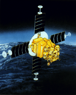
NOAA-18, also known as NOAA-N before launch, was an operational, polar orbiting, weather satellite series operated by the National Environmental Satellite Service (NESS) of the National Oceanic and Atmospheric Administration (NOAA). NOAA-18 also continued the series of Advanced TIROS-N (ATN) spacecraft begun with the launch of NOAA-8 (NOAA-E) in 1983 but with additional new and improved instrumentation over the NOAA A-M series and a new launch vehicle. NOAA-18 was in an afternoon equator-crossing orbit and was intended to replace NOAA-17 as the prime afternoon spacecraft.
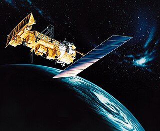
NOAA-15, also known as NOAA-K before launch, is an operational, polar-orbiting of the NASA-provided Television Infrared Observation Satellite (TIROS) series of weather forecasting satellite operated by National Oceanic and Atmospheric Administration (NOAA). NOAA-15 was the latest in the Advanced TIROS-N (ATN) series. It provided support to environmental monitoring by complementing the NOAA/NESS Geostationary Operational Environmental Satellite program (GOES).

Soil Moisture Active Passive (SMAP) is a NASA environmental monitoring satellite launched on 31 January 2015. It was one of the first Earth observation satellites developed by NASA in response to the National Research Council's Decadal Survey.
X-ray emission occurs from many celestial objects. These emissions can have a pattern, occur intermittently, or as a transient astronomical event. In X-ray astronomy many sources have been discovered by placing an X-ray detector above the Earth's atmosphere. Often, the first X-ray source discovered in many constellations is an X-ray transient. These objects show changing levels of X-ray emission. NRL astronomer Dr. Joseph Lazio stated: " ... the sky is known to be full of transient objects emitting at X- and gamma-ray wavelengths, ...". There are a growing number of recurrent X-ray transients. In the sense of traveling as a transient, the only stellar X-ray source that does not belong to a constellation is the Sun. As seen from Earth, the Sun moves from west to east along the ecliptic, passing over the course of one year through the twelve constellations of the Zodiac, and Ophiuchus.
Fenton Hill Observatory is an astronomical research facility operated by Los Alamos National Laboratory in the Jemez Mountains of New Mexico, about 35 miles (56 km) west of Los Alamos. The site is home to several astronomical experiments and observatories spanning 30 acres (120,000 m2). It is also known as Technical Area 57 (TA-57) and is located at an elevation of 8,700 feet (2,700 m) in a region shielded from light pollution. Los Alamos National Laboratory has a use agreement with the Forest Service for the 30 acres (120,000 m2), which is located near Fenton Lake State Park.

The Suomi National Polar-orbiting Partnership, previously known as the National Polar-orbiting Operational Environmental Satellite System Preparatory Project (NPP) and NPP-Bridge, is a weather satellite operated by the United States National Oceanic and Atmospheric Administration (NOAA). It was launched in 2011 and continues to operate in January 2022.

Nimbus 4 was a meteorological satellite. It was the fourth in a series of the Nimbus program.
