Highly elliptical orbit

Last updated
Molniya orbit for the Northern hemisphere NASA molniya oblique.png
Molniya orbit for the Northern hemisphere

A highly elliptical orbit (HEO) is an elliptic orbit with high eccentricity, usually referring to one around Earth. Examples of inclined HEO orbits include Molniya orbits, named after the Molniya Soviet communication satellites which used them, and Tundra orbits.

Such extremely elongated orbits have the advantage of long dwell times at a point in the sky during the approach to, and descent from, apogee. Bodies moving through the long apogee dwell appear to move slowly, and remain at high altitude over high-latitude ground sites for long periods of time. This makes these elliptical orbits useful for communications satellites. Geostationary orbits cannot serve high latitudes because their elevation above the horizon from these ground sites is too low. [1]

Groundtrack of a Molniya orbit Molniya.jpg
Groundtrack of a Molniya orbit
The groundtrack of a QZSS orbit Qzss-45-0.09.jpg
The groundtrack of a QZSS orbit

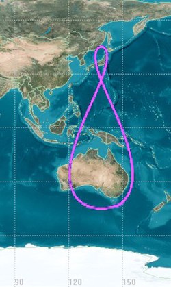
Sirius Satellite Radio used inclined HEO orbits, specifically the Tundra orbits, to keep two satellites positioned above North America while another satellite quickly sweeps through the southern part of its 24-hour orbit. The longitude above which the satellites dwell at apogee in the small loop remains relatively constant as Earth rotates. The three separate orbits are spaced equally around the Earth, but share a common ground track. [2]

Related Research Articles

<span class="mw-page-title-main">Geosynchronous orbit</span> Orbit keeping the satellite at a fixed longitude above the equator

A geosynchronous orbit is an Earth-centered orbit with an orbital period that matches Earth's rotation on its axis, 23 hours, 56 minutes, and 4 seconds. The synchronization of rotation and orbital period means that, for an observer on Earth's surface, an object in geosynchronous orbit returns to exactly the same position in the sky after a period of one sidereal day. Over the course of a day, the object's position in the sky may remain still or trace out a path, typically in a figure-8 form, whose precise characteristics depend on the orbit's inclination and eccentricity. A circular geosynchronous orbit has a constant altitude of 35,786 km (22,236 mi).

<span class="mw-page-title-main">Geostationary orbit</span> Circular orbit above Earths Equator and following the direction of Earths rotation

A geostationary orbit, also referred to as a geosynchronous equatorial orbit (GEO), is a circular geosynchronous orbit 35,786 km (22,236 mi) in altitude above Earth's equator and following the direction of Earth's rotation.

<span class="mw-page-title-main">Communications satellite</span> Artificial satellite that relays radio signals

A communications satellite is an artificial satellite that relays and amplifies radio telecommunication signals via a transponder; it creates a communication channel between a source transmitter and a receiver at different locations on Earth. Communications satellites are used for television, telephone, radio, internet, and military applications. Many communications satellites are in geostationary orbit 22,300 miles (35,900 km) above the equator, so that the satellite appears stationary at the same point in the sky; therefore the satellite dish antennas of ground stations can be aimed permanently at that spot and do not have to move to track the satellite. Others form satellite constellations in low Earth orbit, where antennas on the ground have to follow the position of the satellites and switch between satellites frequently.

<span class="mw-page-title-main">Low Earth orbit</span> Orbit around Earth between 160 and 2000 km

A low Earth orbit (LEO) is an orbit around Earth with a period of 128 minutes or less and an eccentricity less than 0.25. Most of the artificial objects in outer space are in LEO, with an altitude never more than about one-third of the radius of Earth.

<span class="mw-page-title-main">Satellite constellation</span> Group of artificial satellites working together as a system

A satellite constellation is a group of artificial satellites working together as a system. Unlike a single satellite, a constellation can provide permanent global or near-global coverage, such that at any time everywhere on Earth at least one satellite is visible. Satellites are typically placed in sets of complementary orbital planes and connect to globally distributed ground stations. They may also use inter-satellite communication.

<span class="mw-page-title-main">Geostationary transfer orbit</span> Hohmann transfer orbit used to reach geosynchronous or geostationary orbit

A geosynchronous transfer orbit or geostationary transfer orbit (GTO) is a type of geocentric orbit. Satellites that are destined for geosynchronous (GSO) or geostationary orbit (GEO) are (almost) always put into a GTO as an intermediate step for reaching their final orbit.

<span class="mw-page-title-main">Polar orbit</span> Satellite orbit with high inclination

A polar orbit is one in which a satellite passes above or nearly above both poles of the body being orbited on each revolution. It has an inclination of about 60 - 90 degrees to the body's equator.

A geocentric orbit or Earth orbit involves any object orbiting Earth, such as the Moon or artificial satellites. In 1997, NASA estimated there were approximately 2,465 artificial satellite payloads orbiting Earth and 6,216 pieces of space debris as tracked by the Goddard Space Flight Center. More than 16,291 objects previously launched have undergone orbital decay and entered Earth's atmosphere.

<span class="mw-page-title-main">Molniya (satellite)</span> Soviet military surveillance and communications satellites

The Molniya series satellites were military and communications satellites launched by the Soviet Union from 1965 to 2004. These satellites used highly eccentric elliptical orbits known as Molniya orbits, which have a long dwell time over high latitudes. They are suited for communications purposes in polar regions, in the same way that geostationary satellites are used for equatorial regions.

<span class="mw-page-title-main">Molniya orbit</span> Type of high-latitude satellite orbit

A Molniya orbit is a type of satellite orbit designed to provide communications and remote sensing coverage over high latitudes. It is a highly elliptical orbit with an inclination of 63.4 degrees, an argument of perigee of 270 degrees, and an orbital period of approximately half a sidereal day. The name comes from the Molniya satellites, a series of Soviet/Russian civilian and military communications satellites which have used this type of orbit since the mid-1960s.

<span class="mw-page-title-main">Space-Based Infrared System</span> Missile warning and defence system

The Space-Based Infrared System (SBIRS) is a United States Space Force system intended to meet the United States' Department of Defense infrared space surveillance needs through the first two to three decades of the 21st century. The SBIRS program is designed to provide key capabilities in the areas of missile warning, missile defense, battlespace characterization and technical intelligence via satellites in geosynchronous Earth orbit (GEO), sensors hosted on satellites in highly elliptical orbit (HEO), and ground-based data processing and control.

<span class="mw-page-title-main">High Earth orbit</span> Geocentric orbit with an altitude entirely above that of a geosynchronous orbit

High Earth orbit (HEO) is a region of space around the Earth where satellites and other spacecraft are placed in orbits that are very high above the planet's atmosphere. This area is defined as an altitude higher than 35,786 km above sea levelHEO extends to end of the Earth's sphere of influence. Satellites in HEO are primarily used for communication, navigation, scientific research, and military applications. A variety of satellites, such as TESS, have been placed in HEO.

<span class="mw-page-title-main">Quasi-Zenith Satellite System</span> Navigation satellites

The Quasi-Zenith Satellite System (QZSS), also known as Michibiki (みちびき), is a four-satellite regional time transfer system and a satellite-based augmentation system developed by the Japanese government to enhance the United States-operated Global Positioning System (GPS) in the Asia-Oceania regions, with a focus on Japan. The goal of QZSS is to provide highly precise and stable positioning services in the Asia-Oceania region, compatible with GPS. Four-satellite QZSS services were available on a trial basis as of 12 January 2018, and officially started on 1 November 2018. A satellite navigation system independent of GPS is planned for 2023 with 7 satellites.

<span class="mw-page-title-main">Tundra orbit</span> Highly elliptical and highly inclined synchronous orbit

A Tundra orbit is a highly elliptical geosynchronous orbit with a high inclination, an orbital period of one sidereal day, and a typical eccentricity between 0.2 and 0.3. A satellite placed in this orbit spends most of its time over a chosen area of the Earth, a phenomenon known as apogee dwell, which makes them particularly well suited for communications satellites serving high-latitude regions. The ground track of a satellite in a Tundra orbit is a closed figure 8 with a smaller loop over either the northern or southern hemisphere. This differentiates them from Molniya orbits designed to service high-latitude regions, which have the same inclination but half the period and do not loiter over a single region.

<span class="mw-page-title-main">Medium Earth orbit</span> Earth-centered orbit above low Earth orbit and below geostationary orbit

A medium Earth orbit (MEO) is an Earth-centered orbit with an altitude above a low Earth orbit (LEO) and below a high Earth orbit (HEO) – between 2,000 and 35,786 km above sea level.

<span class="mw-page-title-main">Ground track</span> Path on the surface of the Earth or another body directly below an aircraft or satellite

A ground track or ground trace is the path on the surface of a planet directly below an aircraft's or satellite's trajectory. In the case of satellites, it is also known as a suborbital track, and is the vertical projection of the satellite's orbit onto the surface of the Earth.

<span class="mw-page-title-main">Geosynchronous satellite</span> Satellite with an orbital period equal to Earths rotation period

A geosynchronous satellite is a satellite in geosynchronous orbit, with an orbital period the same as the Earth's rotation period. Such a satellite returns to the same position in the sky after each sidereal day, and over the course of a day traces out a path in the sky that is typically some form of analemma. A special case of geosynchronous satellite is the geostationary satellite, which has a geostationary orbit – a circular geosynchronous orbit directly above the Earth's equator. Another type of geosynchronous orbit used by satellites is the Tundra elliptical orbit.

<span class="mw-page-title-main">Spektr-R</span> Russian satellite

Spektr-R was a Russian scientific satellite with a 10 m (33 ft) radio telescope on board. It was launched on 18 July 2011 on a Zenit-3F launcher from Baikonur Cosmodrome, and was designed to perform research on the structure and dynamics of radio sources within and beyond the Milky Way. Together with some of the largest ground-based radio telescopes, the Spektr-R formed interferometric baselines extending up to 350,000 km (220,000 mi).

References

  1. Fortescue, P.W.; Mottershead, L.J.; Swinerd, G.; Stark, J.P.W. (2003). "Section 5.7: highly elliptic orbits". Spacecraft Systems Engineering. John Wiley and Sons. ISBN   0-471-61951-5.
  2. "The Tundra Orbit". Canadian Satellite Tracking and Orbit Research (CASTOR). 23 May 2010. Retrieved 2 October 2017.