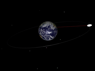
 Figure 4: A constellation of three Molniya spacecraft providing service for the Northern hemisphere. P is the orbital period. A green line corresponds to service for Asia and Europe with the visibility of figures 6–8. A red line corresponds to service for North America with the visibility of figures 9–11.
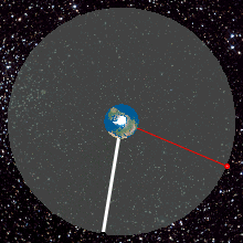
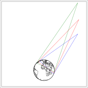 Figure 5: Illumination zones (at least 10° elevation) from a Molniya orbit. At apogee, the green illumination zone applies. At three hours before or after apogee, the red zone applies. At four hours before or after apogee, the blue zone applies. The plane of the figure is the longitudinal plane of apogee rotating with the Earth. In the eight-hour period centered at the apogee passage, the longitudinal plane is almost fixed, the longitude of the satellite varies by only ±2.7°. The views of the Earth from these three points are displayed in figures 6–11.
 Figure 6: View of the Earth four hours before apogee from a Molniya orbit under the assumption that the longitude of the apogee is 90° E. The spacecraft is at an altitude of 24,043 km over the point 92.65° E 47.04° N.
 Figure 7: View of the Earth from the apogee of a Molniya orbit under the assumption that the longitude of the apogee is 90° E. The spacecraft is at an altitude of 39,867 km over the point 90° E 63.43° N.
 Figure 8: View of the Earth four hours after apogee from a Molniya orbit under the assumption that the longitude of the apogee is 90° E. The spacecraft is at an altitude of 24,043 km over the point 87.35° E 47.04° N
 Figure 9: View of the Earth four hours before apogee from a Molniya orbit under the assumption that the longitude of the apogee is 90° W. The spacecraft is at an altitude of 24,043 km over the point 87.35° W 47.04° N.
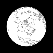 Figure 10: View of the Earth from the apogee of a Molniya orbit under the assumption that the longitude of the apogee is 90° W. The spacecraft is at an altitude of 39,867 km over the point 90° W 63.43° N.
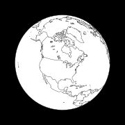 Figure 11: View of the Earth 4 hours after apogee from a Molniya orbit under the assumption that the longitude of the apogee is 90° W. The spacecraft is at an altitude of 24,043 km over the point 92.65° W 47.04° N.
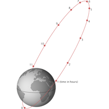

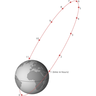
A Molniya orbit (Russian:Молния,IPA: [ˈmolnʲɪjə] , "Lightning") is a type of satellite orbit designed to provide communications and remote sensing coverage over high latitudes. It is a highly elliptical orbit with an inclination of 63.4 degrees, an argument of perigee of 270 degrees, and an orbital period of approximately half a sidereal day. [1] The name comes from the Molniya satellites, a series of Soviet/Russian civilian and military communications satellites which have used this type of orbit since the mid-1960s. A variation on the Molniya orbit is the so-called Three Apogee (TAP) orbit, whose period is a third of a sidereal day.
Contents
- History
- Uses
- Southern hemisphere proposals
- Molniya constellations
- Diagrams
- Properties
- Argument of perigee
- Orbital inclination
- Orbital period
- Eccentricity
- Semi-major axis
- Modelling
- See also
- References
- External links
The Molniya orbit has a long dwell time over the hemisphere of interest, while moving very quickly over the other. In practice, this places it over either Russia or Canada for the majority of its orbit, providing a high angle of view to communications and monitoring satellites covering these high-latitude areas. Geostationary orbits, which are necessarily inclined over the equator, can only view these regions from a low angle, hampering performance. In practice, a satellite in a Molniya orbit serves the same purpose for high latitudes as a geostationary satellite does for equatorial regions, except that multiple satellites are required for continuous coverage. [2]
Satellites placed in Molniya orbits have been used for television broadcasting, telecommunications, military communications, relaying, weather monitoring, early warning systems and classified surveillance purposes.