Related Research Articles

Vanguard 1 is an American satellite that was the fourth artificial Earth-orbiting satellite to be successfully launched, following Sputnik 1, Sputnik 2, and Explorer 1. It was launched 17 March 1958. Vanguard 1 was the first satellite to have solar electric power. Although communications with the satellite were lost in 1964, it remains the oldest human-made object still in orbit, together with the upper stage of its launch vehicle.
Orbital elements are the parameters required to uniquely identify a specific orbit. In celestial mechanics these elements are considered in two-body systems using a Kepler orbit. There are many different ways to mathematically describe the same orbit, but certain schemes, each consisting of a set of six parameters, are commonly used in astronomy and orbital mechanics.
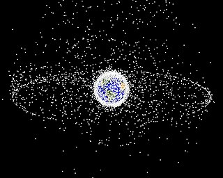
Space debris are defunct human-made objects in space—principally in Earth orbit—which no longer serve a useful function. These include derelict spacecraft—nonfunctional spacecraft and abandoned launch vehicle stages—mission-related debris, and particularly numerous in Earth orbit, fragmentation debris from the breakup of derelict rocket bodies and spacecraft. In addition to derelict human-made objects left in orbit, other examples of space debris include fragments from their disintegration, erosion and collisions or even paint flecks, solidified liquids expelled from spacecraft, and unburned particles from solid rocket motors. Space debris represents a risk to spacecraft.

LAGEOS, Laser Geodynamics Satellite or Laser Geometric Environmental Observation Survey, are a series of two scientific research satellites designed to provide an orbiting laser ranging benchmark for geodynamical studies of the Earth. Each satellite is a high-density passive laser reflector in a very stable medium Earth orbit (MEO).
In astrodynamics, orbital station-keeping is keeping a spacecraft at a fixed distance from another spacecraft or celestial body. It requires a series of orbital maneuvers made with thruster burns to keep the active craft in the same orbit as its target. For many low Earth orbit satellites, the effects of non-Keplerian forces, i.e. the deviations of the gravitational force of the Earth from that of a homogeneous sphere, gravitational forces from Sun/Moon, solar radiation pressure and air drag, must be counteracted.
The United States Space Surveillance Network (SSN) detects, tracks, catalogs and identifies artificial objects orbiting Earth, e.g. active/inactive satellites, spent rocket bodies, or fragmentation debris. The system is the responsibility of United States Space Command and operated by the United States Space Force.
A two-line element set (TLE) is a data format encoding a list of orbital elements of an Earth-orbiting object for a given point in time, the epoch. Using a suitable prediction formula, the state at any point in the past or future can be estimated to some accuracy. The TLE data representation is specific to the simplified perturbations models, so any algorithm using a TLE as a data source must implement one of the SGP models to correctly compute the state at a time of interest. TLEs can describe the trajectories only of Earth-orbiting objects. TLEs are widely used as input for projecting the future orbital tracks of space debris for purposes of characterizing "future debris events to support risk analysis, close approach analysis, collision avoidance maneuvering" and forensic analysis.
The Kessler syndrome, proposed by NASA scientist Donald J. Kessler in 1978, is a scenario in which the density of objects in low Earth orbit (LEO) due to space pollution is high enough that collisions between objects could cause a cascade in which each collision generates space debris that increases the likelihood of further collisions. In 2009 Kessler wrote that modeling results had concluded that the debris environment was already unstable, "such that any attempt to achieve a growth-free small debris environment by eliminating sources of past debris will likely fail because fragments from future collisions will be generated faster than atmospheric drag will remove them". One implication is that the distribution of debris in orbit could render space activities and the use of satellites in specific orbital ranges difficult for many generations.
The International Designator, also known as COSPAR ID, is an international identifier assigned to artificial objects in space. It consists of the launch year, a three-digit incrementing launch number of that year and up to a three-letter code representing the sequential identifier of a piece in a launch. In TLE format the first two digits of the year and the dash are dropped.
The Satellite Catalog Number is a sequential nine-digit number assigned by the United States Space Command (USSPACECOM) in the order of launch or discovery to all artificial objects in the orbits of Earth and those that left Earth's orbit. The first catalogued object, catalog number 1, is the Sputnik 1 launch vehicle, with the Sputnik 1 satellite having been assigned catalog number 2. Objects that fail to orbit or orbit for a short time are not catalogued. The minimum object size in the catalog is 10 centimeters in diameter. As of November 15, 2022, the catalog listed 54,200 objects, including 14,102 satellites that had been launched into orbit since 1957 of which 7,043 were still active. 24,146 of the objects were well tracked while 1,850 were lost. In addition USSPACECOM was also tracking 20,900 analyst objects. Analyst objects are variably tracked and in constant flux, so their catalog and element set data are not published. As of November 7, 2022 ESA estimated there were about 36,500 pieces of orbiting debris that are large enough for USSPACECOM to track.
A geosynchronous satellite is a satellite in geosynchronous orbit, with an orbital period the same as the Earth's rotation period. Such a satellite returns to the same position in the sky after each sidereal day, and over the course of a day traces out a path in the sky that is typically some form of analemma. A special case of geosynchronous satellite is the geostationary satellite, which has a geostationary orbit – a circular geosynchronous orbit directly above the Earth's equator. Another type of geosynchronous orbit used by satellites is the Tundra elliptical orbit.

The 1st Space Operations Squadron is a United States Space Force unit responsible for space-based space domain awareness. Located at Schriever Space Force Base, Colorado, the squadron operates the Space Based Space Surveillance system, the Advanced Technology Risk Reduction system, the Operationally Responsive Space-5 satellite, and the Geosynchronous Space Situational Awareness Program.
DANDE is a 50 kg class spacecraft developed by the University of Colorado Boulder was the winner of the 5th iteration of the Air Force Research Laboratory's University Nanosat Program.

In 2015, the maiden spaceflights of the Chinese Long March 6 and Long March 11 launch vehicles took place.

TDRS-11, known before launch as TDRS-K, is an American communications satellite which is operated by NASA as part of the Tracking and Data Relay Satellite System. The eleventh Tracking and Data Relay Satellite is the first third-generation spacecraft.

Eglin AFB Site C-6 is a United States Space Force radar station which houses the AN/FPS-85 phased array radar, associated computer processing system(s), and radar control equipment. Commencing operations in 1969, the AN/FPS-85 was the first large phased array radar. The entire radar/computer system is located at a receiver/transmitter building and is supported by the site's power plant, fire station, 2 water wells, and other infrastructure for the system. As part of the US Space Force's Space Surveillance Network its mission is to detect and track spacecraft and other manmade objects in Earth orbit for "the Combined Space Operations Center satellite catalogue". With a peak radiated power of 32 megawatts the Space Force claims it is the most powerful radar in the world, and can track a basketball-sized object up to 22,000 nautical miles (41,000 km) from Earth.
Kosmos 2499 is a Russian satellite currently orbiting the Earth.
BSTAR is a way of modeling aerodynamic drag on a satellite in the simplified general perturbation model 4 satellite orbit propagation model.
References
- 1 2 3 Miura, Nicholas Zwiep (2009). "COMPARISON AND DESIGN OF SIMPLIFIED GENERAL PERTURBATION MODELS". California Polytechnic State University, San Luis Obispo.
- 1 2 Hoots, Felix R.; Ronald L. Roehrich (31 December 1988). "Models for Propagation of NORAD Element Sets" (PDF). United States Department of Defense Spacetrack Report (3). Retrieved 16 June 2010.
- 1 2 3 Vallado, David A.; Paul Crawford; Richard Hujsak; T. S. Kelso (August 2006). "Revisiting Spacetrack Report #3" (PDF). Astrodynamics Specialist Conference. doi:10.2514/6.2006-6753. ISBN 978-1-62410-048-2 . Retrieved 29 April 2017.
- ↑ "Planetary Data System". NASA Science Mission Directorate. Retrieved 16 June 2010.
- ↑ Kelso, Dr. T. S. "CelesTrak: Publications [AIAA 2006-6753]". www.celestrak.com. Celestrak. Retrieved 15 April 2019.
- ↑ Gray, Bill (30 March 2019). "sat_code: Code for the SGP4/SDP4 satellite motion model". Github. Retrieved 15 April 2019.
- 1 2 Vallado, David A; Crawford, Paul; Hujsak, Richard. "Revisiting Spacetrack Report #3: Rev 1" (PDF). Celestrak. AIAA. Retrieved 15 April 2019.