
The Arctic Archipelago, also known as the Canadian Arctic Archipelago, is an archipelago lying to the north of the Canadian continental mainland, excluding Greenland and Iceland.
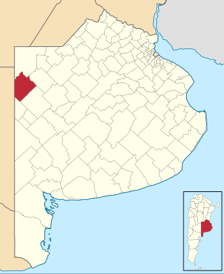
Rivadavia is a partido in the northwest of Buenos Aires Province, Argentina, on the border with La Pampa Province. It has an area of 3,940 square kilometres (1,520 sq mi), and a population of 15,452.

Palmer Land is the portion of the Antarctic Peninsula, Antarctica that lies south of a line joining Cape Jeremy and Cape Agassiz. This application of Palmer Land is consistent with the 1964 agreement between the Advisory Committee on Antarctic Names and the UK Antarctic Place-Names Committee, in which the name Antarctic Peninsula was approved for the major peninsula of Antarctica, and the names Graham Land and Palmer Land for the northern and southern portions, respectively. The line dividing them is roughly 69° S.
The Tapley Mountains is a range of mountains fronting on the eastern side of the Scott Glacier, extending eastward for 35 nautical miles between Leverett Glacier and Albanus Glacier in the Queen Maud Mountains of Antarctica.
The Prince Olav Mountains is a mountain group in the Queen Maud Mountains in Antarctica stretching from Shackleton Glacier to Liv Glacier at the head of the Ross Ice Shelf.
Tucker Glacier is a major valley glacier of Victoria Land, Antarctica, about 90 nautical miles long, flowing southeast between the Admiralty Mountains and the Victory Mountains to the Ross Sea. There is a snow saddle at the glacier's head, just west of Homerun Range, from which the Ebbe Glacier flows northwestward.

Valoria la Buena is a municipality located in the province of Valladolid, Castile and León, Spain. According to the 2018 census (INE), the municipality has a population of 647 inhabitants.
The Mariner Glacier is a major glacier over 60 nautical miles long, descending southeast from the plateau of Victoria Land, Antarctica, between Mountaineer Range and Malta Plateau, and terminating at Lady Newnes Bay, Ross Sea, where it forms the floating Mariner Glacier Tongue.

Vertente do Lério is a municipality/city in the state of Pernambuco in Brazil. The population in 2020, according with IBGE was 7,571 inhabitants and the total area is 73.63 km2.
Rennick Glacier is broad glacier, nearly 200 nautical miles long, which is one of the largest in Antarctica. It rises on the polar plateau westward of Mesa Range and is 20 to 30 nautical miles wide, narrowing to 10 nautical miles near the coast. It takes its name from Rennick Bay where the glacier reaches the sea.
On the continent of Antarctica, the Aramis Range is the third range south in the Prince Charles Mountains, situated 11 miles southeast of the Porthos Range and extending for about 30 miles in a southwest–northeast direction. It was first visited in January 1957 by Australian National Antarctic Research Expeditions (ANARE) southern party led by W.G. Bewsher, who named it for a character in Alexandre Dumas' novel The Three Musketeers, the most popular book read on the southern journey.
The Anderson Hills are an irregular group of hills, ridges and peaks between Mackin Table and the Thomas Hills in the Patuxent Range, Pensacola Mountains, Antarctica.

Whitecloud Glacier is a glacier which flows northward between Klokotnitsa Ridge on the east and Tsarevets Buttress on the west to discharge into Charcot Bay just west of Almond Point, Trinity Peninsula. Named by United Kingdom Antarctic Place-Names Committee (UK-APC) in 1960. The name is descriptive of cloud conditions that prevailed at the time of Falkland Islands Dependencies Survey (FIDS) survey of the area in 1948.

Frölich Peak is a peak 1,035 metres (3,400 ft) high, rising above Holst Point and dominating tree at the head of Beascochea Bay on the west coast of Graham Land, Antarctica.
Pettus Glacier is a narrow deeply entrenched glacier 9 nautical miles (17 km) long, which flows north from Ebony Wall into Gavin Ice Piedmont between Poynter Hill and Tinsel Dome, Trinity Peninsula. Named by United Kingdom Antarctic Place-Names Committee (UK-APC) for Robert N. Pettus, aircraft pilot with Falkland Islands and Dependencies Aerial Survey Expedition (FIDASE), 1956–57.
The Harold Byrd Mountains are a group of exposed mountains and nunataks which extend in an east–west direction between the lower part of Leverett Glacier and the head of the Ross Ice Shelf in Antarctica. They were discovered in December 1929 by the Byrd Antarctic Expedition geological party under Laurence Gould, and named by Rear Admiral Richard E. Byrd for D. Harold Byrd, a cousin of his and a contributor towards the purchase of furs for the expedition.
The La Gorce Mountains are a group of mountains, 20 nautical miles long, standing between the tributary Robison Glacier and Klein Glacier at the east side of the upper reaches of the Scott Glacier, in the Queen Maud Mountains of Antarctica.