External links
| | This article about an organisation in the United Kingdom is a stub. You can help Wikipedia by expanding it. |
Spitalfields Neighbourhood Planning Forum (SNPF) is a neighbourhood forum made up of local Spitalfields residents, business operators and community organisations who represent the range of interests in the 'Spitalfields Neighbourhood Area' (which is a business neighbourhood area). The area covered is a small part of the London Borough of Tower Hamlets, London, mainly along that borough's western border with the City of London. The bounds of the neighbourhood area were designed to cover a similar area to the ancient parish of Spitalfields.
The Spitalfields Neighbourhood Planning Forum was officially designated by Mayor of Tower Hamlets John Biggs in April 2016. The conditions for neighbourhood forum designation are set out in the Town and Country Planning Act 1990 and the powers of neighbourhood forums to create neighbourhood plans are set out in the Localism Act 2011. Tower Hamlets has several other neighbourhood forums in Limehouse, East Shoreditch and the Isle of Dogs that have been similarly designated by the council and which allow local people to help shape neighbourhood planning policies and local services in their area.
| | This article about an organisation in the United Kingdom is a stub. You can help Wikipedia by expanding it. |

Bethnal Green is an area in the East End of London, England, 3 miles (4.8 km) northeast of Charing Cross. The area emerged from the small settlement which developed around the Green, much of which survives today as Bethnal Green Gardens, beside Cambridge Heath Road. By the 16th century the term applied to a wider rural area, the Hamlet of Bethnal Green, which subsequently became a Parish, then a Metropolitan Borough before merging with neighbouring areas to become the north-western part of the new London Borough of Tower Hamlets.

Shoreditch is a district in the East End of London in England, and forms the southern part of the London Borough of Hackney. Neighbouring parts of Tower Hamlets are also perceived as part of the area.

The London Borough of Tower Hamlets is a borough of London, England. Situated on the north bank of the River Thames and immediately east of the City of London, the borough spans much of the traditional East End of London and includes much of the regenerated London Docklands area. The 2019 mid-year population for the borough is estimated at 324,745.
Parish councils are civil local authorities found in England which are the lowest tier of local government. They are elected corporate bodies, with variable tax raising powers, and they carry out beneficial public activities in geographical areas known as civil parishes. There are about 10,480 parish and town councils in England. Parish councils may be known by different styles, they may resolve to call themselves a town council, village council, community council, neighbourhood council, or if the parish has city status, it may call itself a city council. However their powers and duties are the same whatever name they carry.

Inner London is the name for the group of London boroughs that form the interior part of Greater London and are surrounded by Outer London. With its origins in the bills of mortality, it became fixed as an area for statistics in 1847 and was used as an area of local government from 1855 to 1965 principally as the County of London or earlier as the Metropolitan Board of Works Area (metropolis). It now has two common definitions. The first is the statutory definition delineated in the London Government Act 1963, coming into force on 1 April 1965, comprising twelve Inner London boroughs and almost identical to the County of London that was abolished at the same time. The second is the definition used by the Office for National Statistics comprising eleven of the statutory Inner London boroughs and two of the statutory Outer London boroughs, as well as the City of London.

Bishopsgate was one of the eastern gates in London's former defensive wall. The gate's name is traditionally attributed to Earconwald, who was Bishop of London in the 7th century. It was first built in Roman times and marked the beginning of Ermine Street, the ancient road running from London to York (Eboracum). The gate was rebuilt twice in the 15th and 18th centuries, but was permanently demolished in 1760.

Spitalfields is a district in the East End of London and within the London Borough of Tower Hamlets. The area is formed around Commercial Street and includes the locale around Brick Lane, Christ Church, Toynbee Hall and Commercial Tavern. It has several markets, including Spitalfields Market, the historic Old Spitalfields Market, Brick Lane Market and Petticoat Lane Market. It was part of the ancient parish of Stepney in the county of Middlesex and was split off as a separate parish in 1729. Just outside the City of London, the parish became part of the Metropolitan Board of Works area in 1855 as part of the Whitechapel District. It formed part of the County of London from 1889 and was part of the Metropolitan Borough of Stepney from 1900. It was abolished as a civil parish in 1921.

The Metropolitan Borough of Stepney was a Metropolitan borough in the County of London created in 1900. In 1965 it became part of the London Borough of Tower Hamlets.

Bow is an area of East London within the London Borough of Tower Hamlets. It is primarily a built-up and mostly residential area and is 4.6 miles (7.4 km) east of Charing Cross.

Bethnal Green and Bow is a constituency in Greater London, represented in the House of Commons of the UK Parliament since 2010 by Rushanara Ali of the Labour Party.

Christ Church Spitalfields is an Anglican church built between 1714 and 1729 to a design by Nicholas Hawksmoor. On Commercial Street in the East End and in today's Central London it is in the London Borough of Tower Hamlets, on its western border facing the City of London, it was one of the first of the so-called "Commissioners' Churches" built for the Commission for Building Fifty New Churches, which had been established by an Act of Parliament in 1711.
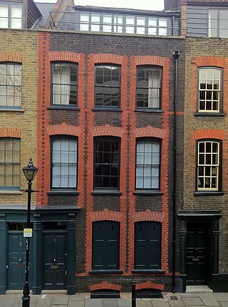
Fournier Street, formerly Church Street, is a street of 18th-century houses in Spitalfields in the East End of London. It is in the London Borough of Tower Hamlets and runs between Commercial Street and Brick Lane. The street is named after a man of Huguenot extraction, George Fournier.

The London Government Act 1963 is an Act of the Parliament of the United Kingdom, which created Greater London and a new local government structure within it. The Act significantly reduced the number of local government districts in the area, resulting in local authorities responsible for larger areas and populations. The upper tier of local government was reformed to cover the whole of the Greater London area and with a more strategic role; and the split of functions between upper and lower tiers was recast. The Act classified the boroughs into inner and outer London groups. The City of London and its corporation were essentially unreformed by the legislation. Subsequent amendments to the Act have significantly amended the upper tier arrangements, with the Greater London Council abolished in 1986, and the Greater London Authority introduced in 2000. As of 2016, the London boroughs are more or less identical to those created in 1965, although with some enhanced powers over services such as waste management and education.

The Old Artillery Ground is an area of land in Spitalfields, London formerly designated one of the Liberties of the Tower of London and Crown Land.
Whitechapel and St George's was a parliamentary constituency in east London, which returned one Member of Parliament (MP) to the House of Commons of the Parliament of the United Kingdom.

Tower Hamlets London Borough Council is the local authority for the London Borough of Tower Hamlets in Greater London, England. The council is unusual in that its executive function is controlled by a directly elected mayor of Tower Hamlets, currently Lutfur Rahman.

The East End of London, often referred to within the London area simply as the East End, is the historic core of wider East London, east of the Roman and medieval walls of the City of London and north of the River Thames. It does not have universally accepted boundaries to the north and east, though the River Lea is sometimes seen as the eastern boundary. Parts of it may be regarded as lying within Central London. The term "East of Aldgate Pump" is sometimes used as a synonym for the area.

Norton Folgate was a liberty in Middlesex, England; adjacent to the City of London in what would become the East End of London.


Whitechapel Road market, also known as Whitechapel Market is a long-established historic London outdoor street market managed by the London Borough of Tower Hamlets which is centered on the A11 thoroughfare of the same name in Whitechapel in the East End of London, next to Whitechapel station and is the focus point of the Whitechapel Market Conservation Area that was set up in 1997 and extended in 2008.