Devín Gate or Hainburger Gate is a natural gate in the Danube valley at the border of Slovakia and Austria. It is one out of four geomorphological areas of the Devín Carpathians, part of the Little Carpathians mountain range. Passau, Devín Gate, and the Iron Gates divide the Danube river into four distinct sections.

Berg is a town in the district of Bruck an der Leitha in Lower Austria in Austria. It, along with neighboring Wolfsthal were part of the municipality of Wolfsthal-Berg until 1996.

Neuenkirchen is a municipality in the Vorpommern-Rügen district, in Mecklenburg-Vorpommern, Germany.

Dersingham Bog is a 159.1-hectare (393-acre) biological and geological Site of Special Scientific Interest Norfolk. It is a Nature Conservation Review site, Grade 2, a National Nature Reserve and a Ramsar site It is part of the Norfolk Coast Area of Outstanding Natural Beauty, and the Roydon Common & Dersingham Bog Special Area of Conservation Part of it is a Geological Conservation Review site.

Boolcoomatta Reserve is a 630 km2 private protected area in eastern South Australia, 463 km north-east of Adelaide and 100 km west of Broken Hill. It is owned and managed by Bush Heritage Australia (BHA).

Serra Negra Biological Reserve is a Biological reserve in the state of Pernambuco, Brazil.
Maningoza Special Reserve is a 9,826 hectares wildlife reserve in Madagascar. It was created in 1956 to protect the many endemic plants and animals, and it also contains some of the last remaining areas of dry deciduous forest on the island.

Kalksburg is a former municipality in Lower Austria that is now a part of the 23rd Viennese district Liesing.

The Harburg Hills are a low ridge in the northeastern part of the German state of Lower Saxony and the southern part of the city state of Hamburg. They are up to 155 metres (509 ft) high.

The Eastern Ore Mountains form a natural region of Saxony that covers the eastern part of the Saxon Ore Mountains range. Together with the Western and Central Ore Mountains, it is part of the larger Saxon Highlands and Uplands region. Its southern continuation beyond the German border covers an area of roughly the same extent in the Czech Republic.

A strict nature reserve or wilderness area is the highest category of protected area recognised by the World Commission on Protected Areas (WCPA), a body which is part of the International Union for Conservation of Nature (IUCN). These category I areas are the most stringently protected natural landscapes.

Devín Carpathians is a subdivision of the Little Carpathians mountain range, located entirely within Bratislava, the capital of Slovakia. It is bordered by the city boroughs of Devín from the west, Devínska Nová Ves from the north, Dúbravka from the east and Karlova Ves from the south. Its highest mountain is Devínska Kobyla at 514 m AMSL, it is also the highest point in Bratislava. The hills are mostly forested with deciduous trees and most of the area is protected by numerous nature reserves, including two geologically important areas: Sandberg containing sands and sandstones from the Cenozoic Paratethys ocean and Jezuitské Lesy containing rare granitic pegmatite bearing niobium-tantalum oxide minerals.
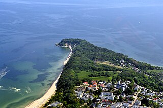
The Nordperd(Perd = Slavic for protrusion or prominence) is a cape on the German Baltic Sea island of Rügen. It is part of the Southeast Rügen Biosphere Reserve and the Mönchgut Nature Reserve.

The Lake Tetzitz, Liddow Peninsula and Banzelvitz Hills Nature Reserve is a nature reserve, 1,088 hectares in area, on the German island of Rügen in Mecklenburg-Western Pomerania. It was officially designated as such on 5 November 1990 and expanded in 1994. Nearby villages are Neuenkirchen and Rappin. The area under protection is a section of the North Rügen Bodden which has a great variety of habitats and is an important roosting and breeding area for the bird world. The elements that give the reserve its name are Lake Tetzitz in the west, the peninsula of Liddow in the centre and the Banzelvitz Hills in the eastern part of the nature reserve. Lake Tetzitz is linked to the Großer Jasmunder Bodden by the channel of the Liddow Strom.
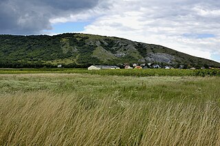
The Hundsheimer Berge is a hill range located in Lower Austria and Burgenland, Austria next to the Devín Gate. It is the most southern part of the Devín Carpathians. The mountain range covers approximately 36 km² and is bordered by the river Danube to the north and east, and the Vienna plate to the south and west. Its highest peak is Hundsheimer Berg. While fairly low, the Hundsheimer Berge rise from only 140 meters above sea level by the Danube.

Hundsheimer Berg is a nature reserve in the Austrian municipalities of Hundsheim and Hainburg an der Donau in the province of Lower Austria located on the slopes of the Hundsheimer Berg. Half of the reserve is owned by WWF Austria with the other half being owned by the municipality of Hundsheim. The Hundsheimer Berg is for example used for excursions by the University of Vienna.
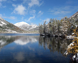
The Okhotsk-Manchurian taiga ecoregion is an area of coniferous forests in the Russian Far East, covering the Amur River delta, the west coast of the Okhotsk Sea, and the rugged extension of the northern Sikhote-Alin Mountains that run southwest-to-northeast through the Primorsky and Khabarovsk regions. It is the southernmost taiga forest in Eurasia. The ecoregion is distinguished from surrounding ecoregions by the slightly warmer climate due to the maritime influence and the shield of the mountains to the west, and by the mixing of flora and fauna species from Okhotsk-Kamchatka communities to the north and Manchurian species from the south. The forest at lower altitudes is "light taiga", and "dark taiga" at higher altitudes.

Colne Point is a 276.4 hectare nature reserve south-west of St Osyth in Essex. It is managed by the Essex Wildlife Trust. It is part of the Colne Estuary Site of Special Scientific Interest, National Nature Reserve. Ramsar site, Nature Conservation Review site and Special Protection Area. It is also part of the Essex Estuaries Special Area of Conservation.
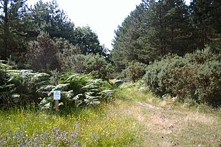
Breckland Forest is an 18,126 hectare biological and geological Site of Special Scientific Interest in many separate areas between Swaffham in Norfolk and Bury St Edmunds in Suffolk. It is part of the Breckland Special Protection Area under the European Union Directive on the Conservation of Wild Birds. It contains two Geological Conservation Review sites, Beeches Pit, Icklingham and High Lodge. Barton Mills Valley is a Local Nature Reserve in the south-west corner of the site.
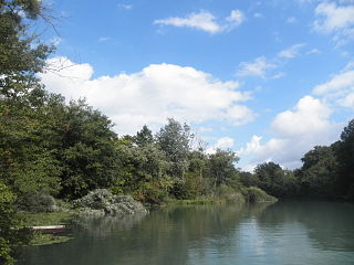
Taubergießen is a floodplain wetland on the southern Upper Rhine in the natural area Offenburg Rhine plain. Taubergießen was declared Naturschutzgebiet in 1979 and, with 1,697 hectares, is one of the largest protected areas in Baden-Württemberg. It has a north-south extension of more than 12 km. The largest width is about 2.5 km.

