
Ferry County is a county located on the northern border of the U.S. state of Washington. As of the 2010 census, the population was 7,551, making it the fourth-least populous county in Washington. The county seat and largest city is Republic. The county was created out of Stevens County in February 1899 and is named for Elisha P. Ferry, the state's first governor.
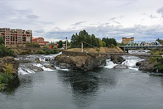
Spokane is the largest city and county seat of Spokane County, Washington, United States. It is in eastern Washington along the Spokane River adjacent to the Selkirk Mountains and west of the Rocky Mountain foothills, 92 miles (148 km) south of the Canadian border, 18 miles (30 km) west of the Washington–Idaho border, and 279 miles (449 km) east of Seattle along I-90.

Northport is a town in Stevens County, Washington, United States. The population was 295 at the 2010 census.

Spokane Valley is a city in Spokane County, Washington, United States, and the largest suburb of Spokane. It is located east of Spokane, west of Coeur d'Alene, Idaho, and surrounds the city of Millwood on three sides. The city incorporated as the City of Spokane Valley on March 31, 2003. The Washington State Office of Financial Management estimates the city's population as 101,060 as of 2019. Spokane Valley is named after the valley of the Spokane River, in which it is located. The city and the general area is colloquially referred to as "The Valley" by residents of the Spokane–Coeur d'Alene area.
Walla Walla can refer to:

The Inland Northwest, historically and alternatively known as the Inland Empire, is a region of the American Northwest centered on the Greater Spokane, Washington Area, encompassing all of Eastern Washington and Northern Idaho. Under broader definitions, Northeastern Oregon and Western Montana may be included in the Inland Northwest. Alternatively, stricter definitions may exclude Central Washington and Idaho County, Idaho.
U.S. Route 2 or U.S. Highway 2 (US 2) is an east–west U.S. Highway spanning 2,571 miles (4,138 km) across the northern continental United States. US 2 consists of two segments connected by various roadways in southern Canada. Unlike some routes, which are disconnected into segments because of encroaching Interstate Highways, the two portions of US 2 were designed to be separate in the original 1926 highway plan.
Eastern Washington is the region of the U.S. state of Washington located east of the Cascade Range. It contains the city of Spokane, the Tri-Cities, the Columbia River and the Grand Coulee Dam, the Hanford Nuclear Reservation and the fertile farmlands of the Yakima Valley and the Palouse. Unlike in Western Washington, the climate is dry, including some desert environments.
U.S. Route 195 (US 195) is a north–south United States Highway, of which all but 0.65 miles of its 94.02 miles are within the state of Washington. The highway starts in rural Idaho north of the city of Lewiston as a state highway in an interchange with US 95. As the road crosses into Washington it becomes a state highway that connects communities in the Palouse region of Eastern Washington. US 195 travels north, serving the cities of Pullman, Colfax and Rosalia in Whitman County before continuing into Spokane County to its terminus in the city of Spokane at an interchange with Interstate 90 (I-90).

The Spokane Valley is a valley of the Spokane River through the southern Selkirk Mountains in the U.S. state of Washington. The valley is home to the cities of Spokane and its suburbs Spokane Valley, Liberty Lake, and Millwood. The valley is bounded on the north and south by the Selkirk Mountains, on the west by the Columbia River Basalt Group, and on the east by the Rathdrum Prairie at the Idaho state border. Mica Peak, located south of the valley, is the southernmost peak in the Selkirk Range. The mountain, along with surrounding peaks, separates the Spokane Valley from the Palouse. The Valley contains part of the Spokane Valley–Rathdrum Prairie Aquifer.

The Idaho Panhandle—locally known as North Idaho—is a salient region of the U.S. state of Idaho encompassing the state's 10 northernmost counties: Benewah, Bonner, Boundary, Clearwater, Idaho, Kootenai, Latah, Lewis, Nez Perce, and Shoshone. The Panhandle is bordered by the state of Washington to the west, Montana to the east, and the Canadian province of British Columbia to the north. The Idaho panhandle, along with Eastern Washington, comprises the region known as the Inland Northwest, headed by its largest city, Spokane, Washington.

This is a list of properties and historic districts in Washington that are listed on the National Register of Historic Places. There are at least three listings in each of Washington's 39 counties.

The MV Spokane is a Jumbo-class ferry operated by Washington State Ferries. She was built in 1972 by the Todd Shipyards in Seattle, Washington, for the Seattle–Bainbridge route. The ship remained assigned there until the construction of the Jumbo Mark II-class in the late 1990s displaced her to the Edmonds–Kingston route, where she has remained since.
The Jumbo class are two ferries that were built by Washington State Ferries in 1972 to supersede the Super class. They have a capacity of 2,000 passengers and 188 vehicles.
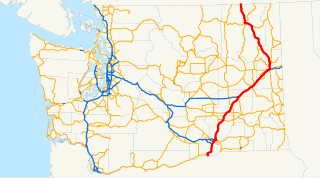
State Route 25 (SR 25), named the Coulee Reservoir Highway, is a 121.17-mile-long (195.00 km) state highway serving communities in Lincoln and Stevens counties in the U.S. state of Washington. The highway begins at an intersection with U.S. Route 2 (US 2) east of Davenport and continues northwest to cross the Spokane River on the Spokane River Bridge. From the bridge, SR 25 parallels the Columbia River and Franklin D. Roosevelt Lake upstream through several small communities, passing the Gifford–Inchelium Ferry, to Kettle Falls. In Kettle Falls, the roadway intersects US 395, co-signed with SR 20 and continues north to Northport, where former SR 251 is intersected and SR 25 crosses the Columbia River on the Northport Bridge. The highway travels northwest to the Canadian border, where it becomes British Columbia Highway 22 (BC 22).
Historic ferries in Oregon are water transport ferries that operated in Oregon Country, Oregon Territory, and the state of Oregon, United States. These ferries allowed people to cross bodies of water, mainly rivers such as the Willamette in the Willamette Valley, and the Columbia, in order to transport goods, move people, and further communications until permanent bridges were built to allow faster crossing of the water. The early ferries were used by wagons and pedestrians, while later ones transported trains and then automobiles. Oregon has a few automobile ferries still in operation.
Interstate 90 (I-90), designated as the American Veterans Memorial Highway, is a transcontinental Interstate Highway that runs from Seattle, Washington, to Boston, Massachusetts. It crosses Washington state from west to east, traveling 298 miles (480 km) from Seattle across the Cascade Mountains and into Eastern Washington, reaching the Idaho state line east of Spokane. I-90 intersects several of the state's other major highways, including I-5 in Seattle, I-82 and U.S. Route 97 (US 97) near Ellensburg, and US 395 and US 2 in Spokane.
U.S. Route 2 (US 2) is a component of the United States Numbered Highway System that connects the city of Everett in the U.S. state of Washington to the Upper Peninsula of Michigan, with a separate segment that runs from Rouses Point, New York, to Houlton, Maine. Within Washington, the highway travels on a 326.36-mile-long (525.23 km) route that connects the western and eastern regions of the state as a part of the state highway system and the National Highway System. US 2 forms parts of two National Scenic Byways, the Stevens Pass Greenway from Monroe to Cashmere and the Coulee Corridor Scenic Byway near Coulee City, and an All-American Road named the International Selkirk Loop within Newport.
U.S. Route 395 (US 395) is a United States Numbered Highway that runs from California to the inland regions of Oregon and Washington. It travels north–south through Washington, including long concurrencies with Interstate 82 (I-82) and I-90, and connects the Tri-Cities region to Spokane and the Canadian border at Laurier.
Spokane Bridge is an unincorporated community and former census-designated place in Spokane County, in the U.S. state of Washington. The community is located on the banks of the Spokane River at the Washington–Idaho border, just south of Interstate 90. The city of Stateline, Idaho is located across the river to the northeast. The community was the site of the first post office in Spokane County