Spokane Valley

Last updated

Spokane Valley
The Valley
ISS007-E-12236 - View of Washington.jpg
Spokane Valley from space
USA Washington relief location map.jpg
Red pog.svg
Spokane Valley
Floor elevation1,896 ft (578 m) [1]
Depth3,309 feet (1,009 m)
Geography
Population centers
Borders on Spokane (west), Selkirk Range (north), Rathdrum Prairie, Idaho (east), Selkirk Range (south)
Coordinates 47°43′03″N117°02′51″W / 47.7174°N 117.047423°W / 47.7174; -117.047423 [1]
Traversed by Interstate 90, Washington State Route 290
Rivers Spokane River, Saltese Creek, Cable Creek

The Spokane Valley is a valley of the Spokane River through the southern Selkirk Mountains in the U.S. state of Washington. The valley is home to the cities of Spokane and its suburbs Spokane Valley, Liberty Lake, and Millwood. The valley is bounded on the north and south by the Selkirk Mountains, on the west by the Columbia River Basalt Group, and on the east by the Rathdrum Prairie at the Idaho state border. Mica Peak, located south of the valley, is the southernmost peak in the Selkirk Range. The mountain, along with surrounding peaks, separates the Spokane Valley from the Palouse. [2] The Valley contains part of the Spokane Valley–Rathdrum Prairie Aquifer.

Contents

Geography

Topography

The valley exhibits signs of the prehistoric geologic events that shaped the area and region such as the Missoula Floods which ended 12,000 to 15,000 years ago. [3] [4] The Spokane valley was gouged out by repeated failures in the ice dam that held Glacial Lake Missoula. [4] The protected Dishman Hills Natural Resources Conservation Area to the west, with its rugged, potholed appearance and deep gullies is a result of the Missoula Floods as well and represents one of the most ecologically diverse regions in Washington state, where forests, grasslands and shrublands converge and is within two ecoregions, the Okanagan and Northern Rockies ecoregions. [5] [4] The geography further to the southeast, such as the Saltese Flats and Saltese Uplands is characterized as a shrub–steppe landscape with grassy hills and ravines. [6]

Spokane Valley panorama from Eagle Peak 20130803.jpg
Panorama of Spokane Valley looking east from Eagle Peak

Climate

Most of the valley is classified as a Mediterranean Climate (Köppen Csa), however the western slope of the Saltese Uplands closely border on a semi-arid climate (Köppen Bsk).

History

Early history

Plante's Crossing on the Spokane River Plante's Crossing-Spokane River and Plains-trail runs N. N. E - NARA - 305507.jpg
Plante's Crossing on the Spokane River

For thousands of years, native peoples lived in the Valley, and included it in their seasonal migrations, where they hunted, fished, gathered, and dug roots. [7] Prior to European settlers, the Valley was occupied the Spokane and Coeur d’Alene people. [8]

Starting in the early 1800s, fur traders sent by the North West Company (later merged with the Hudson's Bay Company) arrived in Spokane territory. West of the Valley, two trading posts were established near the mouth of the Little Spokane, 1810-1826 [9] Northwest of there, missionaries established the Tshimakain Mission, 1838–1848. [10] The first settler in the Valley was Antoine Plante, a French Canadian and Blackfoot, and his wife, Mary of the Flathead nation. He came as an employee of the Hudson's Bay Company, for which he worked for two years before becoming a Freeman. He built a small cabin near the Spokane River in 1849 (now the Plantes Ferry Recreation Park between the neighborhoods of Trentwood and Irwin), from which he ran a small Hudson's Bay Company trading post. He operated the first ferry across the Spokane River, the only means of crossing the river in the area, from 1852 to 1864. [11] [12]

Washington Territory

In 1853, two years after the establishment of the Washington Territory, the first governor, Isaac Stevens, made an initial effort to make a treaty with Chief Garry and the Spokanes at Antoine Plantes' cabin. [13] [14] In spite of the calming influence of Chief Garry, the Spokanes protested the loss of their lands by joining in the Coeur d'Alene War of 1858. The battle culminated in the Battle of Spokane Plains, while there was no decisive winner, the tribes were greatly weakened. [15] The Spokanes were forced from the lands of their ancestors to a reservation north of the Spokane River, just west of the Spokane area.

In 1862, A. C. "Charley" Kendall established a store on the north side of the Spokane River at the far east end of the Valley. A bridge to cross the river at Kendall's store was soon built by Joe Herring, Timothy Lee, and Ned Jordan in 1864, strategically located nearer the Mullan Road than Plante's Ferry. A small community, known as Spokane Bridge, began to build up near the bridge. It boasts the first hotel and post office in the Valley. In 1871, it became a stop on the Pony Express, connecting The Dalles, Oregon Territory, to Missoula, Montana Territory. [16] [17]

Before the turn of the century, early pioneers, many of them silver miners, arrived from the East by way of the Northern Pacific and Great Northern railroads, for which Spokane was a major hub. By 1883, the first transcontinental rail was established. The railroad activity created support for extensive shops and facilities. Within a few years, Spokane was tied to the outside world by five transcontinental railroads, making it the hub of commerce it remains today.

Early 1900s

Irrigation efforts stimulated population growth in the Spokane Valley significantly in the early part of the 20th century. Developers and real estate speculators tapped into nearby lakes, the Spokane River and the aquifer lying under the valley in an effort to turn the dry land into saleable agricultural land. In 1899, the Spokane Valley Land and Water Co., later owned by long-time irrigation advocate D.C. Corbin, built a canal to irrigate land in the Greenacres area with water from Liberty Lake. In 1905, the Spokane Canal Company built a canal to irrigate the Otis Orchard area with water from Newman Lake, and Modern Irrigation and Land Company tapped into the underground aquifer to irrigate 3,000 acres (12 km2) in Opportunity. Within just twenty years, 30,000 acres (120 km2) of dry land was converted into fertile farmland. Water access greatly increased land values. Valley population grew from 1,000 residents in 1900 to nearly 10,000 by 1922. Extensive apple orchards thrived in the gravelly soil of the Valley, and by 1912 nearly 2 million apple trees had been planted. A huge packing plant was built in 1911 by the Spokane Valley Growers Union.

The Spokane Valley was developed as townships. In 1908, the state granted the formation of county townships as semi-autonomous, self-governing bodies, with the same basic governing rights as most municipalities, including the ability to levy property taxes. Only Spokane and Whatcom counties took full advantage of these townships with taxing capabilities, essentially reducing the need to incorporate rural communities. These townships fulfilled the basic needs for services in the rural districts until the State revoked their taxing rights in 1969, after which the unfunded townships declined until the Spokane County voted to disorganize them in 1974. The Valley townships were East Spokane, Opportunity and Greenacres, the southern edge of Pleasant Prairie, Foothills, and Newman, and the northern edge of Chester. [18]

A few Spokane Valley towns developed for residential and/or business purposes. Trent (now Irwin) was originally platted as a residential area for Northern Pacific railroad workers in 1881. Millwood (originally Woodward) began as a "company town", developed by Inland Empire Paper Mill for their employees, and Dishman developed primarily as a business center. All other Valley townships were developed as irrigation districts and owe their existence to their agricultural roots. Between 1901 and 1915, the communities of Orchard Avenue, Greenacres, Otis Orchards, Opportunity, Vera, Dishman, Liberty Lake, Newman Lake, East Spokane, Mica and Chester were platted. Pasadena Park is a populated place located in Spokane County at latitude 47.697 and longitude -117.283, North of Millwood across the Spokane River that existed at least as early as 1916. [19]

The Spokane Valley was promoted as a wonderful place to live. Though most Valley residents were farmers or orchardists, canneries, brickyards, railroad maintenance facilities and lumber mills provided jobs for many. The beauty of the surrounding area, pleasant communities, fertile farmlands, business opportunities, outdoor sports and activities, local recreational areas and community organizations caused it to be called "Spokane Valley, the Valley Bountiful". As the population increased, small communities with schools, churches, businesses, community clubs and organizations thrived. Tied to Spokane, local lakes and Coeur d’Alene by railroads and bus systems, the people of the Valley enjoyed a full life.

In the years that followed, crop troubles and irrigation system maintenance problems prompted many residents to sell their farms in five, ten, or 20-acre (81,000 m2) plots for suburban home sites. Many of the apple trees were pulled out and replaced by neighborhoods and truck farms. The truck farms were successful in raising strawberries, raspberries, tomatoes, beans, peas, watermelons, asparagus, squash, cucumbers and thousands of acres of Heart of Gold cantaloupes. Dairy, poultry and fur farms also appeared in the Valley during these years.

1930s to 1950s

While jobs were scarce during the Great Depression, most people in the Spokane Valley had enough land to grow food for their families. The Spokane Valley Chamber of Commerce adhered to a positive agenda throughout these hard times. They placed street signs on Valley roads and in an effort to show solidarity with Spokane, east–west roads were renamed to correspond with Spokane's roads. Observing that fires were a constant and catastrophic problem for area residents, the Chamber lobbied to begin a fire protection district in the Valley. Their efforts were successful and Valley residents were first offered fire protection in 1940, with the formation of Spokane County Fire Protection District Number One.

Spokane University, a four-year liberal arts college operated in the Spokane Valley from 1913 to 1933. when it closed due to financial difficulties amid the Great Depression. [20] [21] It briefly reopened as Spokane Valley Junior College, before facilities were moved to Spokane's South Hill and merged into the newly formed Spokane Junior College in 1935. [22] The campus of Spokane University was eventually used by University High School from 1962 until 2002, when it relocated to new facilities. [23] The campus has been occupied by Valley Christian School since 2005. [24]

The people of the valley always maintained independence from the City of Spokane on its borders. The first local newspaper, The Spokane Valley Herald, was launched in 1920. In 1919 an early municipal airfield was carved out, later named Felts Field in honor of Herald owner Buell Felts who died in a plane crash there. A streetcar line was started as early as 1908, and later extended to Liberty Lake in the east part of the valley, where entertainment facilities were built for music and outdoor gatherings. Other than Millwood, which incorporated in 1927 and Liberty Lake, Washington which did so in 2001, the Valley remained unincorporated throughout the 20th century.

Industry began to replace agriculture more rapidly after the completion of Grand Coulee Dam in 1941, which combined cheap electricity with readily available water from the Spokane River and the extensive aquifer which underlies the Valley. At its height, the Valley was the site for an aluminum plant, a cement plant and a paper mill. Plans to attract light industry through the establishment of an industrial park at a former military depot were not very successful. The cement plant closed in the 1950s, but the paper mill and aluminum plant remain.

In the 1950s a further transformation swept the valley as the post World War II population boom began to push into the valley, replacing most of the remaining apple orchards with tracts of houses. The first shopping mall was built at University Village on Sprague Avenue (formerly called Appleway), which became the major artery through the Valley, lined with stores and restaurants. The last large-scale orchard irrigations ended in the late 1950s, canvas pipes running down residential streets replacing the old ditches by that time.

Last half of 20th century

In the later decades of the last century, the Valley experienced a large influx of retirees due to inexpensive housing and the relatively dry weather. Retirement complexes and apartment blocks began to appear. At the present time the Valley remains principally a suburban area, a mixture of families and retirees and the retail commerce to support them. In the 1990s and the early part of the twenty-first century the Spokane Valley continued to grow more urban, becoming one of the fastest growing regions in the state. Commercial growth increased and joined residential growth as it moved towards the state line. The urban development included the opening of the long-awaited Spokane Valley Mall in 1997, the establishment of dozens of other businesses along business corridors, and the development of the Mirabeau Point community complex.

Cities, Towns, and Communities

Protected Natural Areas

See also

Related Research Articles

<span class="mw-page-title-main">Spokane County, Washington</span> County in Washington, United States

Spokane County is a county located in the U.S. state of Washington. As of the 2020 census, its population was 539,339, making it the fourth-most populous county in Washington. The largest city and county seat is Spokane, the second largest city in the state after Seattle. The county is named after the Spokane tribe.

<span class="mw-page-title-main">Liberty Lake, Washington</span> City in Washington, United States

Liberty Lake is a city in Spokane County, Washington, United States located adjacent to the eponymous lake. Located just over a mile west of the Washington–Idaho border, Liberty Lake is both a suburb of Spokane, Washington and a bedroom community to Coeur d'Alene, Idaho. The population was 12,003 at the 2020 census.

<span class="mw-page-title-main">Otis Orchards-East Farms, Washington</span> CDP in Washington, United States

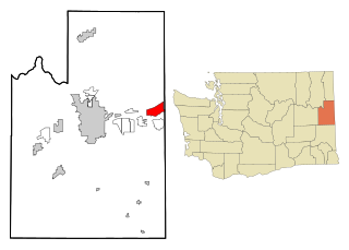
Otis Orchards-East Farms is a census-designated place (CDP) in Spokane County, Washington, United States, near the county's border with Idaho. The population was 6,299 at the 2020 census. The CDP includes the unincorporated communities of Otis Orchards and East Farms. Otis Orchards contains the bulk of the businesses of the community.

<span class="mw-page-title-main">Spokane, Washington</span> City in Washington, United States

Spokane is the largest city in and county seat of Spokane County, Washington, United States. It is in eastern Washington, along the Spokane River, adjacent to the Selkirk Mountains, and west of the Rocky Mountain foothills, 92 miles (148 km) south of the Canadian border, 18 miles (30 km) west of the Washington–Idaho border, and 279 miles (449 km) east of Seattle, along I-90.

<span class="mw-page-title-main">Spokane Valley, Washington</span> City in Washington, United States

Spokane Valley is a city in Spokane County, Washington, United States, and the largest suburb of Spokane. It is located east of Spokane, west of Coeur d'Alene, Idaho, and surrounds the city of Millwood on three sides. The city incorporated as the City of Spokane Valley on March 31, 2003. The population was 102,976 at the 2020 census, making it the eighth-largest city in Washington state. Spokane Valley is named after the valley of the Spokane River, in which it is located. The city and the general area is colloquially referred to as "The Valley" by residents of the Spokane–Coeur d'Alene area.

<span class="mw-page-title-main">Inland Northwest</span> Region

The Inland Northwest, historically and alternatively known as the Inland Empire, is a region of the American Northwest centered on the Greater Spokane, Washington Area, encompassing all of Eastern Washington and North Idaho. Under broader definitions, Northeastern Oregon and Western Montana may be included in the Inland Northwest. Alternatively, stricter definitions may exclude Central Washington and Idaho County, Idaho.

<span class="mw-page-title-main">Missoula floods</span> Heavy floods of the last ice age

The Missoula floods were cataclysmic glacial lake outburst floods that swept periodically across eastern Washington and down the Columbia River Gorge at the end of the last ice age. These floods were the result of periodic sudden ruptures of the ice dam on the Clark Fork River that created Glacial Lake Missoula. After each ice dam rupture, the waters of the lake would rush down the Clark Fork and the Columbia River, flooding much of eastern Washington and the Willamette Valley in western Oregon. After the lake drained, the ice would reform, creating Glacial Lake Missoula again.

<span class="mw-page-title-main">Spokane River</span> River in Idaho and Washington state, United States

The Spokane River is a tributary of the Columbia River, approximately 111 miles (179 km) long, in northern Idaho and eastern Washington in the United States. It drains a low mountainous area east of the Columbia, passing through the Spokane Valley and the city of Spokane, Washington.

<span class="mw-page-title-main">Columbia Basin Project</span> American irrigation project

The Columbia Basin Project in Central Washington, United States, is the irrigation network that the Grand Coulee Dam makes possible. It is the largest water reclamation project in the United States, supplying irrigation water to over 670,000 acres (2,700 km2) of the 1,100,000 acres (4,500 km2) large project area, all of which was originally intended to be supplied and is still classified irrigable and open for the possible enlargement of the system. Water pumped from the Columbia River is carried over 331 miles (533 km) of main canals, stored in a number of reservoirs, then fed into 1,339 miles (2,155 km) of lateral irrigation canals, and out into 3,500 miles (5,600 km) of drains and wasteways. The Grand Coulee Dam, powerplant, and various other parts of the CBP are operated by the Bureau of Reclamation. There are three irrigation districts in the project area, which operate additional local facilities.

<span class="mw-page-title-main">Lake Coeur d'Alene</span> Glacial lake in Idaho, US

Lake Coeur d'Alene, officially Coeur d'Alene Lake, is a natural dam-controlled lake in North Idaho, located in the Pacific Northwest region of the United States. At its northern end is the city of Coeur d'Alene. It spans 25 miles (40 km) in length and ranges from 1 to 3 miles (5 km) wide with over 109 miles (175 km) of shoreline.

<span class="mw-page-title-main">Central Valley School District</span> School district in Spokane Valley, Washington, U.S.

Central Valley School District No. 356 is a K–12 public school district located in Spokane Valley and Liberty Lake, Washington. Over 14,100 students attend one of the twenty-one schools within the district.

<span class="mw-page-title-main">Dishman Hills</span> Mountains in Washington (state), United States

Dishman Hills Natural Resources Conservation Area is a 530-acre (210 ha) area protected by a combination of public and non-profit groups, located in Spokane County, Washington. The granite outcroppings, forming the bulk of the area, were originally formed 70 million years ago, by volcanic magma pushing up through the Earth's crust and then cooling. The protected Dishman Hills Natural Resources Conservation Area with its rugged, potholed appearance and deep gullies is a result of the Missoula Floods and represents one of the most ecologically diverse regions in Washington state, where forests, grasslands and shrublands converge and is within two ecoregions, the Okanagan and Northern Rockies ecoregions. The hills consist of small ravines, ponds, and large chunks of granite, that support an eco-system consisting mainly of ponderosa pine, as well as about 300 different flowering plants, and 73 different species of mushrooms. The area also supports wildlife, such as coyotes, marmots, white-tailed deer, pheasants, and dozens of species of butterflies. The Dishman Hills rise immediately south of the Dishman section of The City of Spokane Valley. Continuing south, out of the park, the elevation continues to rise to the Rocks of Sharon and the Iller Creek Conservation Area near the peak of Krell Hill.

<span class="mw-page-title-main">Columbia Plateau (ecoregion)</span> Xeric shrubland ecoregion of Canada and the United States

The Columbia Plateau ecoregion is a Level III ecoregion designated by the United States Environmental Protection Agency (EPA) encompassing approximately 32,100 square miles (83,139 km2) of land within the U.S. states of Washington, Oregon, and Idaho. The ecoregion extends across a wide swath of the Columbia River Basin from The Dalles, Oregon to Lewiston, Idaho to Okanogan, Washington near the Canada–U.S. border. It includes nearly 500 miles (800 km) of the Columbia River, as well as the lower reaches of major tributaries such as the Snake and Yakima rivers and the associated drainage basins. It is named for the Columbia Plateau, a flood basalt plateau formed by the Columbia River Basalt Group during the late Miocene and early Pliocene. The arid sagebrush steppe and grasslands of the region are flanked by moister, predominantly forested, mountainous ecoregions on all sides. The underlying basalt is up to 2 miles (3 km) thick and partially covered by thick loess deposits. Where precipitation amounts are sufficient, the deep loess soils have been extensively cultivated for wheat. Water from the Columbia River is subject to resource allocation debates involving fisheries, navigation, hydropower, recreation, and irrigation, and the Columbia Basin Project has dramatically converted much of the region to agricultural use.

<span class="mw-page-title-main">Spokane metropolitan area</span> Metropolitan statistical area in Washington, United States

The Spokane–Spokane Valley Metropolitan Statistical Area, as defined by the United States Census Bureau, is an area consisting of Spokane and Stevens counties in Washington state, anchored by the city of Spokane and its largest suburb, Spokane Valley. As of July 1, 2021, the MSA had an estimated population of 593,466. The Spokane Metropolitan Area and the neighboring Coeur d'Alene metropolitan area, make up the larger Spokane–Coeur d'Alene combined statistical area. The urban areas of the two MSAs largely follow the path of Interstate 90 between Spokane and Coeur d'Alene. In 2010, the Spokane–Spokane Valley MSA had a gross metropolitan product of $20.413 billion.

<span class="mw-page-title-main">Saltese Flats</span>

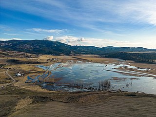
The Saltese Flats is a flat located in Spokane County, Washington, United States. The flats are occupied by the residual wetlands of the now-drained Saltese Lake. The term Saltese Flats is generally used to refer to both the flat and the occupying wetlands. The wetlands—which are overlooked by the Saltese Uplands—are primarily fed by Quinnamose and Saltese Creeks, and are also emptied by the latter.

<span class="mw-page-title-main">Spokane Valley–Rathdrum Prairie Aquifer</span>

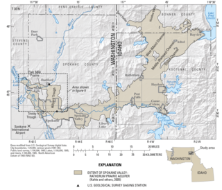
The Spokane Valley–Rathdrum Prairie Aquifer is an aquifer in the northwest United States, located in eastern Washington and northern Idaho.

<span class="mw-page-title-main">Liberty Lake (Washington)</span> Lake in Washington state,US

Liberty Lake is a lake in Spokane County in the U.S. state of Washington. The lake is located about 800 feet (240 m) south of the eponymous city, and is a popular fishing spot. The lake is part of the Spokane Valley–Rathdrum Prairie Aquifer. Besides the aquifer, the only outflow is a small unnamed stream that ends at a small ephemeral pond a little over 1 mile (1.9 km) to the North.

<span class="mw-page-title-main">Liberty Park (Spokane, Washington)</span>

Liberty Park is a 22 acres (8.9 ha) public park at Third Ave and Perry St in East Central, Spokane, Washington. It is open daily with entry gratis.

References

  1. 1 2 "Spokane Valley". Geographic Names Information System . United States Geological Survey, United States Department of the Interior.
  2. "SummitPost". SummitPost.org . Retrieved September 1, 2016.
  3. Breckenridge, Roy M. (May 1993). Glacial Lake Missoula and the Spokane Floods (PDF) (Report). GeoNotes. Vol. 26. Idaho Geological Survey. Archived from the original (PDF) on April 26, 2012. Retrieved November 29, 2011.
  4. 1 2 3 "Map of Dishman Hills" (PDF). dnr.wa.gov. Retrieved July 30, 2023.
  5. "Dishman Hills Natural Resources Conservation Area | WA - DNR".
  6. Geology of the Saltese Uplands Conservation Area Archived October 20, 2020, at the Wayback Machine
  7. Jones & Stokes (2007). "Addendum Cultural Resources Survey Report. Bigelow Gulch/Forker Road Urban Connector Project". May. Prepared for Spokane County Public Works, Division of Engineering and Roads. Bellevue, WA.
  8. Ruby, Robert H.; Brown, John A. (2006). The Spokane Indians: Children of the Sun. Norman, Oklahoma: University of Oklahoma Press. p. 5. ISBN   978-0-8061-3761-2.
  9. Phillips, James W. (1971). Washington State Place Names. Seattle, Washington: University of Washington Press. pp. 134–135. ISBN   0-295-95158-3.
  10. Arksey, Laura. "Chewelah — Thumbnail History". HistoryLink. Retrieved August 18, 2020.
  11. "Plante's Ferry on the Spokane River 1852-1864". Spokane History Timeline. Discovery School. Retrieved August 14, 2020.
  12. Sanders, Benjamin. "Plante's Ferry Park". Spokane Historical. Retrieved August 14, 2020.
  13. Tate, Cassandra (April 3, 2013). "Cayuse Indians". Essay 10365. HistoryLink. Retrieved November 22, 2014.
  14. Kershner, Jim (August 1, 2008). "Chief Spokane Garry (ca. 1811–1892)". Essay 8713. HistoryLink. Retrieved November 22, 2014.
  15. Woodworth-Ney, Laura (2004). Mapping identity . Boulder: University Press of Colorado. p. 66. ISBN   0870817612.
  16. McArthur, Tom (October 31, 2012). "History — Spokane Bridge: An Inland Northwest original". The Liberty Lake Splash. Liberty Lake, WA. Retrieved August 19, 2020.
  17. Singleton, Jayne (2019). "Bridge Builders and Ferry Men in the Spokane Valley". Spokane Valley Heritage Museum. Retrieved August 19, 2020.
  18. Lambeth, Robert M. "Spokane Valley Heritage Museum/Opportunity Township Hall". Spokane Historical. Retrieved August 14, 2020.
  19. http://washington.hometownlocator.com/wa/spokane/pasadena-park.cfm Hometown Locator: Pasadena Park
  20. Kassa, Thomas. "Spokane University". Spokane Historical. Retrieved August 17, 2020.
  21. "Spokane Valley -- Thumbnail History". HistoryLink. Retrieved August 17, 2020.
  22. "Expand Spokane Junior College". The Spokesman-Review. March 23, 1935. p. 7. Retrieved August 17, 2020 via Google News Archive.
  23. "History – About Us". Central Valley School District. Retrieved August 17, 2020.
  24. "History". Valley Christian School. Retrieved August 17, 2020.