
Spokane County is a county located in the U.S. state of Washington. As of the 2010 census the population was 471,221, making it the fourth-most populous county in Washington state. The largest city and county seat is Spokane, the second largest city in the state, behind Seattle.

The Spokane River is a tributary of the Columbia River, approximately 111 miles (179 km) long, in northern Idaho and eastern Washington in the United States. It drains a low mountainous area east of the Columbia, passing through the Spokane Valley and the city of Spokane, Washington.
The Tiffin River is a 54.9-mile-long (88.4 km) tributary of the Maumee River in northwestern Ohio in the United States. Headwater tributaries of the river rise in southeastern Michigan. The river drains a primarily rural farming region in the watershed of Lake Erie. Early French traders called the river Crique Féve, translated as Bean Creek, due to the natural growth of bean plants along the shores.
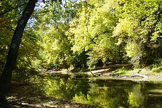
The Little Spokane River is a major tributary of the Spokane River, approximately 35 mi (56 km) long, in eastern Washington in the United States. It drains a rural area of forested foothills and a farming valley north of the city of Spokane along the Idaho–Washington border. It has two branches one starting west of Newport and the other comes from Eloika lake which is further west. The two branches come together about a quarter mile east of Milan. The supply from Eloika is quite warm in the summer and has different fish habitat than the colder branch from Newport. The best trout fishing is where the two branches come together, but is on private owned land. It is also a privately owned water body, which is rare.

Lost River begins and ends in a closed basin in northern California and southern Oregon in the United States. The river, 60 miles (97 km) long, flows in an arc from Clear Lake Reservoir in Modoc County, California, through Klamath County, Oregon, to Tule Lake in Siskiyou County, California. About 46 mi (74 km) of Lost River are in Oregon, and 14 miles (23 km) are in California.
Crooked Creek is a 26.3-mile-long (42.3 km) tributary of the Tioga River located entirely in Tioga County, Pennsylvania in the United States.

Glenbrook is a census-designated place (CDP) on the east shore of Lake Tahoe in Douglas County, Nevada, United States. The population was 215 at the 2010 census.
Rice Creek is a tributary of the Mississippi River in the northern suburbs of the Minneapolis–St. Paul metropolitan area of Minnesota in the United States. It is approximately 28 miles (45 km) long and drains a watershed of 201 square miles (520 km2).

Lacamas Creek is in Clark County, Washington, United States, and flows about 12.5 miles (20.1 km) from headwaters near Camp Bonneville to Lacamas Lake and Round Lake in Camas, and eventually into the Washougal River. Its name is derived from that of the native camas plant. Lacamas Creek is fed by numerous streams, but the five largest tributaries are Matney Creek, Shanghai Creek, Fifth Plain Creek, China Ditch, and Dwyer Creek.
Broad Run is a tributary of the Potomac River in Loudoun County, Virginia. The creek, located between Goose Creek and Sugarland Run, principally drains portions of eastern Loudoun County, as well as a small portion of western Fairfax County.

Jefferson Township is one of thirteen townships in Grant County, Indiana, United States. As of the 2010 census, its population was 5,839 and it contained 1,758 housing units.

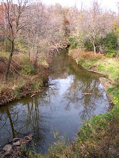
Latah Creek, officially known as Hangman Creek, is a large stream in eastern Washington and north central Idaho in the United States. The creek flows northwest from the Rocky Mountains to Spokane, where it empties into the Spokane River. It drains 673 square miles (1,740 km2) in parts of Benewah and Kootenai counties in Idaho, Spokane County and a small portion of Whitman County in Washington, where over 64 percent of its watershed resides. Some major tributaries of the approximately 60-mile (97 km) creek include Little Latah Creek and Rock Creek. The average flow of the creek can range from 20 cubic feet per second (0.57 m3/s) to 20,000 cubic feet per second (570 m3/s). Latah Creek receives its name from a Nez Perce word likely meaning "fish". In 1854, the creek received another name, Hangman Creek, from a war between the Palouse Indians and white soldiers, which resulted in several Palouse being hanged alongside the creek.

The Fall Kill is a creek in Dutchess County, New York, United States. The stream is approximately 38 miles (61 km) long, and joins the Hudson River in the city of Poughkeepsie.
Beaver Run is a tributary of Bowman Creek in Luzerne County and Wyoming County, in Pennsylvania, in the United States. It is approximately 7.7 miles (12.4 km) long and flows through Lake Township in Luzerne County and Noxen Township in Wyoming County. The watershed of the stream has an area of 10.6 square miles (27 km2). It is not designated as an impaired waterbody. The surficial geology in its vicinity includes alluvial fan, alluvial terrace, alluvium, Wisconsinan Till, Wisconsinan Ice-Contact Stratified Drift, fill, wetlands, and bedrock.
Kern Run is a tributary of Middle Creek in Snyder County, Pennsylvania, in the United States. It is approximately 5.7 miles (9.2 km) long and flows through Spring Township, Beaver Township, and Beavertown. The watershed of the stream has an area of 12.3 square miles (32 km2). The stream has two named tributaries: Luphers Run and Wetzel Run. Kern Run is dammed in one place to produce a 24-acre (9.7 ha) lake for drinking water and flood control. Some reaches of the stream are impaired. A number of bridges have also been constructed across it. The drainage basin of the stream is designated as a Coldwater Fishery and a Migratory Fishery. Wild trout naturally reproduce within it.
Nine Partners Creek is a tributary of Tunkhannock Creek in Susquehanna County, Pennsylvania, in the United States. It is approximately 10 miles (16 km) long and flows through New Milford Township, Harford Township, and Lenox Township. The watershed of the creek has an area of 38.6 square miles (100 km2). The creek has two named tributaries: Butler Creek and Leslie Creek. The surficial geology in the vicinity of Nine Partners Creek includes Wisconsinan Till, alluvium, bedrock, alluvial fan, and wetlands. The creek's drainage basin is designated as a Coldwater Fishery and a Migratory Fishery.
The Saltese Flats are residual wetlands of the drained Saltese Lake in Spokane County, Washington, United States. The wetlands—which are overlooked by the Saltese Uplands—are fed by the Quinnamose Creek and Saltese Creek, and are also emptied by the latter. The wetlands were originally drained for farming, but the Spokane County Environmental Services are actively trying to restore them. The primary goal is to restore the wetlands habitat, and increase late summer water flow into the Spokane River.

Liberty Lake is a lake in Spokane County in the U.S. state of Washington. The lake is located about 800 feet (0.25 km) south of its eponymous city, and is a popular fishing spot. The lake is part of the Spokane Valley–Rathdrum Prairie Aquifer. Besides the aquifer, the only outflow is a small unnamed perennial stream that ends at a small ephemeral pond a little over 1 mile (1.9 km) to the North.

