Spokane County is a county located in the U.S. state of Washington. As of the 2020 census, its population was 539,339, making it the fourth-most populous county in Washington. The largest city and county seat is Spokane, the second largest city in the state after Seattle. The county is named after the Spokane people.
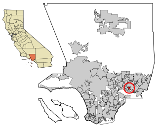
Valinda is a census-designated place (CDP) in the San Gabriel Valley, in Los Angeles County, California, in the United States. At the 2010 census, the population was 22,822, up from 21,776 at the 2000 census.

Prattville is a census-designated place (CDP) in Plumas County, California, United States. The population was 24 at the 2020 census, down from 33 at the 2000 census.
Quail Valley is a former census-designated place (CDP) in Riverside County, California, United States. On October 1, 2008, the community along with the neighboring communities of Sun City and Menifee incorporated as the City of Menifee.

Hurley is an unincorporated community and census-designated place (CDP) in Jackson County, Mississippi, United States. It is part of the Pascagoula Metropolitan Statistical Area. The population was 1,551 at the 2010 census, up from 985 at the 2000 census.

Eagleville is a census-designated place (CDP) in Montgomery County, Pennsylvania, United States. The population was 4,800 at the 2010 census. It is within Lower Providence Township.

Banks Lake South is a census-designated place (CDP) in Grant County, Washington, United States. The population was 234 at the 2020 census.

Ocean City is a census-designated place (CDP) in Grays Harbor County, Washington, United States. The population was 232 at the 2020 census, up from 200 at the 2010 census.

Country Homes is a census-designated place (CDP) in Spokane County, Washington, United States. The population was 6,251 at the 2020 census. The campus of Whitworth University is located in Country Homes. It is a largely suburban area that blends into the north side of the city of Spokane and the neighboring CDPs of Town and Country and Fairwood.

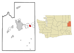
Dishman is a locale and former census-designated place (CDP) in Spokane County, Washington, United States. Founded by Addison T. Dishman (II), who operated a nearby rock quarry in 1889, its population was 10,031 at the 2000 census. Dishman has been part of Spokane Valley since 2003.

Fairwood is a census-designated place (CDP) in Spokane County, Washington, United States. The population was 10,541 at the 2020 census.

Latah is a town in Spokane County, Washington, United States. The population was 185 at the 2020 census. It was named for the nearby creek, Latah Creek, from the native word for fish. The town was formerly called, Hangman's Creek and Alpha.

Liberty Lake is a city in Spokane County, Washington, United States, located adjacent to the eponymous lake. Located just over a mile west of the Washington–Idaho border, Liberty Lake is both a suburb of Spokane, Washington and a bedroom community to Coeur d'Alene, Idaho. The population was 12,003 at the 2020 census.

Millwood is a city in Spokane County, Washington, United States. The population was 1,786 at the 2010 census. Millwood is a suburb of Spokane, and is surrounded on three sides by the city of Spokane Valley. The Spokane River flows along the northern edge of the city. The city is home to the National Register of Historic Places listed Millwood Historic District.

Opportunity is a locale and former census-designated place in Spokane County, Washington, United States. The population was 25,065 at the 2000 census.
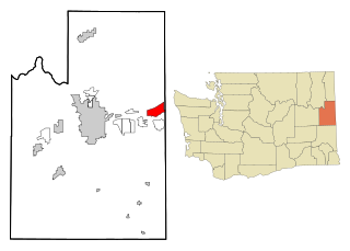
Otis Orchards-East Farms is a census-designated place (CDP) in Spokane County, Washington, United States, near the county's border with Idaho. The population was 6,299 at the 2020 census. The CDP includes the unincorporated communities of Otis Orchards and East Farms. Otis Orchards contains the bulk of the businesses of the community.

Spangle is a city in Spokane County, Washington, United States. The population was 278 at the 2010 census. The name comes from William Spangle, an early pioneer.
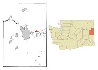
Trentwood is a locale and former census-designated place (CDP) in Spokane County, Washington, United States, east across the Spokane River from Irwin. The population was 4,388 at the 2000 census. Trentwood joined the other unincorporated communities in the region to form the city of Spokane Valley in 2003.

Veradale—originally known as Vera—is a locale and former census-designated place in Spokane County, Washington, United States. The population was 9,387 at the 2000 census. Veradale retains its own post office.

Bethlehem Village is a census-designated place (CDP) within the town of Bethlehem in Litchfield County, Connecticut, United States. The CDP includes the Bethlehem Green Historic District at the town center, as well as surrounding residential and rural land. As of the 2010 census, the CDP had a population of 2,021, out of a population of 3,607 for the entire town of Bethlehem.