
Trout Lake Township is located in north central Minnesota in Itasca County, United States. It is bordered by the City of Coleraine to the west and north, City of Bovey on the north, an unorganized township on the east, and Blackberry Township to the south. Town government was adopted on March 6, 1894. The population was 1,056 at the 2020 census.

Lake Nokomis is one of several lakes in Minneapolis, Minnesota, and part of the city's Chain of Lakes. The lake was previously named Lake Amelia in honor of Captain George Gooding's daughter, Amelia, in 1819. Its current name was adopted in 1910 to honor Nokomis, grandmother of Hiawatha. It is located in the southern part of the city, west of the Mississippi River and south of Lake Hiawatha. The lake is oval in shape, with a long axis running southwest to northeast. Two pathways circle the lake, a 2.7-mile (4.3 km) pedestrian trail and a 2.8-mile (4.5 km) bicycle trail. Because the lower part of the lake is crossed by Cedar Avenue running north–south, the impression from the ground is that the lake is shaped like an L. The lake has an area of 204 acres (0.83 km2).

Muskegon State Park is a public recreation area located four miles (6.4 km) west of North Muskegon in Muskegon County, Michigan. The park's 1,233 acres (499 ha) encompass two miles of sand beach on Lake Michigan and one mile of beach on Muskegon Lake.

Lake Mohave is a reservoir on the Colorado River between the Hoover Dam and Davis Dam in Cottonwood Valley defining the border between Nevada and Arizona in the United States. This 67-mile (108 km) stretch of the Colorado River flows past Boulder City, Nelson, Searchlight, Cottonwood Cove, Cal-Nev-Ari, and Laughlin to the west in Nevada and Willow Beach and Bullhead City to the east in Arizona. A maximum width of 4 miles (6.4 km) wide and an elevation of 647 feet (197 m), Lake Mohave encompasses 28,260 acres (114.4 km2) of water. As Lake Mead lies to the north of the Hoover Dam, Lake Mohave and adjacent lands forming its shoreline are part of the Lake Mead National Recreation Area administered by the U.S. National Park Service.

Thousand Hills State Park is a public recreation area covering some 3,000 acres (1,200 ha) two miles (3.2 km) west of Kirksville in Adair County, Missouri. The state park features 703-acre (284 ha) Forest Lake and Native American petroglyphs.

Summersville Lake is a reservoir located in the US state of West Virginia. The lake is formed by a rock-fill dam on the Gauley River, south of Summersville in Nicholas County. It is the largest lake in West Virginia, with 2,700 acres (1,100 ha) of water and over 60 miles (97 km) of shoreline at the summer pool water level. Its maximum depth is 327 feet. Part of the northern shore of the lake is managed by the West Virginia State Park system.
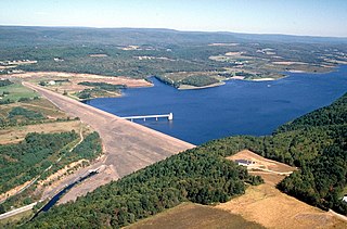
Beltzville State Park is a 2,972.39-acre (1,202.88 ha) Pennsylvania state park in Franklin and Towamensing townships, Carbon County, Pennsylvania in the United States. The park opened in 1972, and was developed around the U.S. Army Corps of Engineers flood control project Beltzville Dam on Pohopoco Creek. The village of Big Creek Valley was vacated in 1966 to make way for Beltzville Lake.
Lake Ore-be-gone is a 140-acre (0.57 km2) artificial lake, formed by the flooding of three open-pit iron ore mines, within the city limits of Gilbert, Minnesota, US.

Pinckney State Recreation Area is a Michigan state recreation area in Dexter, Sylvan and Lyndon Townships, Washtenaw County and Putnam and Unadilla Townships, Livingston County in the U.S. state of Michigan. The park is 11,000 acres (4,500 ha) and sits at an elevation of 922 feet (281 m). The park is connected to the nearby Waterloo State Recreation Area by the 35-mile (56 km) Waterloo–Pinckney Trail. Pinckney State Recreation Area is open for year-round recreation including hiking, fishing, swimming, hunting and a variety of winter sports.

Tolmie State Park is a public recreation area covering 154 acres (62 ha) on Nisqually Beach on Puget Sound, eight miles (13 km) northeast of Olympia, Washington. The state park includes 1,800 ft (550 m) of saltwater shoreline at the mouth of a creek known as Big Slough as well as forest lands, a saltwater marsh, and an underwater park with artificial reef for scuba diving.

Lake Phalen is an urban lake located in Saint Paul, Minnesota and in its suburb of Maplewood. It is one of the largest lakes in Saint Paul and is the centerpiece of the Phalen Regional Park System. The lake drains into the Mississippi River after traveling through Phalen Creek. The lake and surrounding 494-acre (2.00 km2) park receive around 500,000 visitors each year.
Finger Lakes State Park is a public recreation area consisting of 1,128 acres (456 ha) in Boone County near the city of Columbia, Missouri. The state park is unusual in that the site was reclaimed after having been strip mined for coal. It is one of two state parks in Missouri used for off-road vehicles. The history of the other, St. Joe State Park, is also connected with mining. It is adjacent to Rocky Fork Lakes Conservation Area.
Stockton State Park is a public recreation area occupying 2,176 acres (881 ha) on the shore of Stockton Lake, nine miles (14 km) south of Stockton, Missouri. The state park occupies a northward jutting peninsula between the Big Sac and Little Sac arms of the 25,000-acre (10,000 ha) lake, which was created when the U.S. Army Corps of Engineers dammed the Sac River in 1969.

Jackson Lake State Park is a public recreation area covering 106 acres (43 ha) along the shores of 252-acre (102 ha) Jackson Lake in Jackson County, Ohio, in the United States. Recreational activities available at the park include camping, boating, fishing, swimming and picnicking.
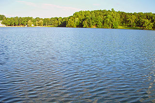
Sylvan Lake is located next to the community by that name in the Town of Beekman, New York, United States. It is the deepest and second-largest lake in Dutchess County.
Clayton Lake State Park is a 510-acre (2.1 km2) Oklahoma state park located in Pushmataha County, Oklahoma, 5 miles (8.0 km) south of Clayton, Oklahoma. It has RV sites and tent camping areas, along with primitive cabins, one family-style two bedroom cabin, picnic tables, group picnic shelters, comfort stations with showers, and boat ramps. The park also has an ADA accessible fishing dock, playground, hiking trails, and swimming beach. The park is 1 of 7 Oklahoma State Parks that are in the path of totality for the 2024 solar eclipse, with 1 minute and 20 seconds of totality.
Tenkiller State Park is a 1,190-acre (4.8 km2) Oklahoma state park located in northwestern Sequoyah County, Oklahoma, near the towns of Vian, Oklahoma and Gore, Oklahoma. Larger towns nearby include Sallisaw, Gore, and Webbers Falls, Oklahoma.

Lake Byllesby is a 1,432-acre artificial lake on the Cannon River in Dakota and Goodhue counties, in the U.S. State of Minnesota. The lake was formed as a result of construction of the Byllesby Dam by the H.M. Byllesby & Company, which would later become Northern States Power Company for hydroelectric power generation. Today, the lake serves as a popular recreational destination and is the largest lake in Southern Dakota County, approximately 30 miles (48 km) southeast of the Twin Cities.
Kiser Lake State Park is a public recreation area in Champaign County, Ohio, located four miles (6.4 km) northwest of St. Paris and 34 miles (55 km) north of Dayton. The 531-acre (215 ha) state park includes 396-acre (160 ha) Kiser Lake, for which it was named, and the 51-acre (21 ha) Kiser Lake Wetlands State Nature Preserve.
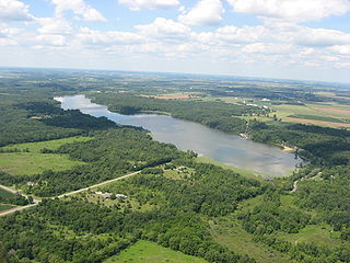
Pleasant Creek State Recreation Area is a 1,927-acre (780 ha) state recreation area in Linn County, Iowa, United States, near the city of Palo. The recreation area is home to the 410-acre (170 ha) Pleasant Creek Lake. Both the lake and the park were formed in the 1960s to provide eastern Iowa with a large recreational lake.
