Related Research Articles
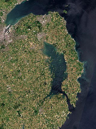
The Ards Peninsula is a peninsula in County Down, Northern Ireland, on the north-east coast of Ireland. It separates Strangford Lough from the North Channel of the Irish Sea. Towns and villages on the peninsula include Donaghadee, Millisle, Portavogie and Portaferry. The large towns of Newtownards and Bangor are at the mainland edge of the peninsula. Burr Point is the easternmost point on the island of Ireland.
St Andrew most commonly refers to Andrew the Apostle, the Christian apostle and brother of Peter.
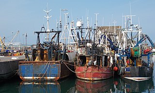
Portavogie is a village, townland and fishing port in County Down, Northern Ireland. It lies within the Ards and North Down Borough and is the easternmost settlement in Ireland. It had a population of 2,122 people in the 2011 Census.

Saul is a village in County Down, Northern Ireland, within the civil parish of Saul and Ballee.

Ballyhalbert is a small village and townland in County Down, Northern Ireland. It is on the east coast of the Ards Peninsula between Ballywalter and Portavogie. It is largely residential and has a small harbour and large caravan site which was formerly a Royal Air Force (RAF) airfield, RAF Ballyhalbert, during World War II. It is within the Ards and North Down Borough. It had a population of 1,026 people in the 2011 Census, up from 447 people in the 2001 Census.

Ballywalter is a village or townland and civil parish in County Down, Northern Ireland. It is on the east coast of the Ards Peninsula between Donaghadee and Ballyhalbert. Ballywalter was formerly known as Whitkirk as far back as the 12th century. It had a population of 2,027 people in the 2011 census.
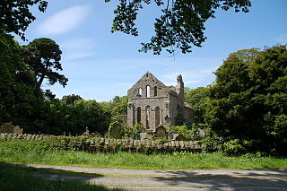
Greyabbey or Grey Abbey is a small village, townland and civil parish located on the eastern shores of Strangford Lough, on the Ards Peninsula in County Down, Northern Ireland.

Ballyrashane is a small village and civil parish outside Coleraine, County Londonderry, Northern Ireland. The civil parish of Ballyrashane covers areas of County Antrim, as well as County Londonderry. It is part of Causeway Coast and Glens district.

Tullylish is a small village, townland and civil parish in County Down, Northern Ireland. It sits on the River Bann, along the main road between the towns of Banbridge and Portadown. In the 2001 census it had a population of 105 people. It lies within the civil parish of Tullylish and Banbridge District.

Kilcoo is a small village and civil parish in County Down, Northern Ireland. It lies between Rathfriland and Castlewellan and is within the Newry, Mourne and Down District Council area. The village is on the A25 Dublin Road 6 kilometres (4 mi) south-west of Castlewellan. Kilcoo had a population 1415 people in the 2001 Census.

Templeport is a civil parish in the barony of Tullyhaw, County Cavan, Ireland. The chief towns in the parish are Bawnboy and Ballymagauran. The large Roman Catholic parish of Templeport containing 42,172 statute acres was split up in the 18th & 19th centuries into three new parishes, Templeport, Corlough and Glangevlin.
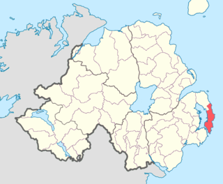
Ards Upper is a barony in County Down, Northern Ireland. It lies on the southern half of the Ards Peninsula in the east of the county, with the Irish Sea to its east and Strangford Lough to its west. It is bordered by two other baronies: Ards Lower to the north; and Lecale Lower just across the mouth of Strangford Lough to the south.

Tullynakill is a civil parish and townland in County Down, Northern Ireland. It is situated in the historic barony of Castlereagh Lower.
Seapatrick is a civil parish in County Down, Northern Ireland. It lies partly across the three historic baronies of Iveagh Upper, Upper Half, Iveagh Lower, Lower Half and Iveagh Lower, Upper Half.
Ardkeen is a civil parish and townland in County Down, Northern Ireland. It is situated in the historic barony of Ards Upper.
Ardquin is a civil parish and townland in County Down, Northern Ireland. It is situated in the historic barony of Ards Upper.

Killaney is a civil parish in County Down, Northern Ireland. It is situated in the historic barony of Castlereagh Upper. It is also a townland of 298 acres. Killaney lies east of Lough Henney, next to an area of bog to the south-west of Saintfield.
References
- 1 2 3 "St. Andrews (alias Ballyhalbert)". IreAtlas Townlands Database. Retrieved 16 May 2015.