
Lough Corrib is a lake in the west of Ireland. The River Corrib or Galway River connects the lake to the sea at Galway. It is the largest lake within the Republic of Ireland and the second largest on the island of Ireland. It covers 176 km² and lies mostly in County Galway with a small area of its northeast corner in County Mayo.

Kinvara or Kinvarra is a sea port village in the southwest of County Galway, Ireland. It is located in the civil parish of Kinvarradoorus in the north of the barony of Kiltartan. Kinvarra is also an electoral division.

Oranmore is a town in County Galway, Ireland, 9 km (5.6 mi) east of Galway city on an inlet of Galway Bay. At the 2022 census, Oranmore had a population of 5,819.

Aughagower or Aghagower is a small village in rural County Mayo in western Ireland. It is located about 6 km from Westport. Aughagower has around 40 houses, 1 pub and a shop, with a clear view of Croagh Patrick from Reek View. It also forms the centre of a parish of the same name which covers an area of 86.1 square miles. The village is known for its links to Saint Patrick and Tóchar Phádraig, the pilgrimage route from Ballintubber Abbey to Croagh Patrick.

Lawrencetown or Laurencetown (Irish: Baile Mór Shíol Anmchadha or simply Baile Mór), historically called Oghilmore and later Ballymore, is a village in County Galway, Ireland. Located on the R355 regional road nine miles south of Ballinasloe, it lies in the barony of Longford, the civil parish of Clonfert, the Catholic parish of Lawrencetown and Kiltormer, and the townland (earlier) of Lissreaghaun and (later) of Laurencetown or Ballymore; it was historically in the poor law union of Ballinasloe.

Terryglass is a village in County Tipperary, Ireland. The small town is located on the R493 regional road on the north-eastern shore of Lough Derg near where the River Shannon enters the Lough. It is a civil parish in the historical barony of Ormond Lower. It is also an Ecclesiastical parish in the Roman Catholic Diocese of Killaloe,. Terryglass won the Irish Tidy Towns Competition in 1983 and 1997.

Brittas Bay in County Wicklow, Ireland is a 4 kilometres (2.5 mi) stretch of beach on the Irish Sea coast, about 12 kilometres (7.5 mi) south of Wicklow. The beach and associated dunes are very popular with Dubliners and are one of the most frequented beaches by residents of the capital during the summer.

Ahascragh is a village in east County Galway, Ireland. It is located 11 km (7 mi) north-west of Ballinasloe on the Ahascragh/Bunowen River, a tributary of the River Suck. The R358 regional road passes through the village. As of the 2022 census, it had a population of 186 people.
Kilcolgan, is a village on the mouth of the Kilcolgan River at Dunkellin Bay in County Galway, Ireland. The settlement is at the junction of the N67 and R458 roads, which lies between Gort and Clarinbridge. The village is near the site of the Galway Bay drowning tragedy. Kilcolgan was designated as a census town by the Central Statistics Office for the first time in the 2016 census, at which time it had a population of 141 people.
Kildaree is a small townland located on the R327 regional road approximately 2.8 miles/4.4 km outside the small village of Williamstown in northeast County Galway, Ireland. It is approximately 1.5 square kilometres (0.58 sq mi) in area.

Firies is a village in County Kerry, Ireland in the historical barony of Magunihy. It is situated midway between the hub towns of Killarney (14.5 km), Tralee (16 km), Castleisland (16 km) and Killorglin (13 km). It is on the R561 road between Farranfore and Castlemaine. The population at the 2016 census was 558. There are two principal rivers, namely the Maine and its chief tributary, the Brown Flesk.
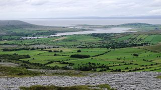
Oughtmama is a civil parish in County Clare. It lies in the Burren, a region in the northwest of the county. It contains many antiquities, including three early-medieval Christian churches, ruined castles, prehistoric cairns and ring forts and two Martello Towers built in the early 19th century.

Kill of the Grange, often Kill o' the Grange, is a suburban community and ancient parish in the half-barony of Rathdown, within the traditional County Dublin, in the jurisdiction of Dún Laoghaire–Rathdown. It contains an early religious site, which is a National Monument. The area, sometimees described as a twin of, and sometimes as part of, Deansgrange, is 5 miles southeast of Dublin.
Tonaroasty is an abandoned village and national monument located in County Galway, Ireland.
Kilcornan is an abandoned village and national monument located in County Galway, Ireland.
Lissard Ringforts are two ringforts and a national monument located in County Galway, Ireland.

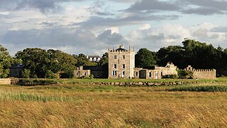
Merlin Park Castle is a tower house and National Monument located in County Galway, Ireland.
Cloonigny Castle is a tower house and National Monument located in County Galway, Ireland.

Drumacoo is a medieval ecclesiastical site and National Monument located in County Galway, Ireland.

Templesaghtmacree is an Early Christian church and National Monument located on Inishmaan, Ireland.
