
Sandy Hill is a neighbourhood in Ottawa, Ontario, located just east of downtown. The neighbourhood is bordered on the west by the Rideau Canal, and on the east by the Rideau River. To the north it stretches to Rideau Street and the Byward Market area while to the south it is bordered by the Queensway highway and Nicholas Street. The area is named for its hilliness, caused by the river, and its sandy soil, which makes it difficult to erect large buildings. It is home to a number of embassies, residences and parks. Le cordon bleu operates its Canadian school there, at the opposite end of Sandy Hill from the University of Ottawa.

St. Andrew's Presbyterian Church is the oldest Presbyterian church in Ottawa, Ontario, Canada.

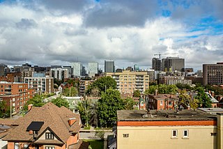
Downtown Ottawa is the central area of Ottawa, Ontario, Canada. It is sometimes referred to as the Central Business District and contains Ottawa's financial district. It is bordered by the Ottawa River to the north, the Rideau Canal to the east, Gloucester Street to the south and Bronson Avenue to the west. This area and the residential neighbourhood to the south are also known locally as 'Centretown'. The total population of the area is 4,876.

Centretown United Church is an historic church located in Ottawa, Ontario, Canada at 507 Bank Street at Argyle in the Centretown area. It was built in 1906 as the Stewarton Presbyterian Church using Gothic Revival architecture under the architecture of Moses Chamberlain Edey, (designer of Heritage site the Aberdeen Pavilion and the Daly Building. The corner stone was laid by Sir Mortimer Clarke, Lieutenant Governor of Ontario. Centretown United Church is a member church of the United Church of Canada.

Christ Church Cathedral is the Anglican cathedral in Ottawa, Ontario, Canada. The church is located at 414 Sparks Street in the northwest section of the city's downtown at the western end of Sparks Street on top of a promontory looking down to the Ottawa River.

St. Elias Antiochian Orthodox Cathedral is an Antiochian Eastern-Orthodox cathedral in Ottawa, Ontario, Canada. It is located at 2975 Riverside Drive just east of Mooney's Bay, south of the Hog's Back Falls. The pastor of the cathedral is Fr. Nektarios Najjar.

First United Church is a United Church of Canada congregation in Ottawa, Ontario, Canada. One of Ottawa's oldest congregations, the church formed in 1846.

St. Peter's Evangelical Lutheran Church is a church in Ottawa, Ontario, Canada situated on Ottawa's ceremonial route and overlooks the Garden of the Provinces, the Ottawa River and the Gatineau Hills. St. Peter's is an Ottawa landmark. The motto is "A community of faith seeking to grow in God's grace and love".

Ottawa Centre is an urban provincial electoral district in Ontario, Canada that has been represented in the Legislative Assembly of Ontario since 1968. While the riding's boundaries have changed over the years to account for population changes, the riding has always comprised the central areas of Ottawa, the nation's capital.

St Brigid's was a Roman Catholic church located in the Lower Town neighbourhood of Ottawa, Ontario, Canada. It was built to serve the English-speaking, Catholic population of the area. In 2007 the church was closed and sold, and is now home to Saint Brigid's Centre for the Arts, an Irish-Canadian heritage centre.

St. Theresa's Catholic Church is a Roman Catholic church on Cartier Street in Ottawa, Ontario, Canada. The church is located in the eastern section of downtown Ottawa, on Somerset Street between Elgin Street and the Rideau Canal.

Église Unie St-Marc is a small but historic church in Ottawa, Canada. It is the main church for francophone Protestants in the Ottawa Gatineau region. French speaking Protestants are a very small minority in Canada, but one with a history dating back to early Huguenot settlers.

The Church of St. John the Evangelist is an Anglican church in Ottawa, Ontario, Canada, at the corner of Elgin and Somerset streets. The church is named in honour of John the Evangelist.
St. Stephen's Anglican Church is an Anglican Church of Canada parish in Ottawa, Ontario, Canada.
All Saints Sandy Hill is a former Anglican church in Ottawa, Ontario, Canada. The building was sold in 2015 and is currently a community hub for the neighbourhood.
Centretown is a neighbourhood in Somerset Ward, in central Ottawa, Ontario, Canada. It is defined by the city as "the area bounded on the north by Gloucester Street and Lisgar Street, on the east by the Rideau Canal, on the south by the Queensway freeway and on the west by Bronson Avenue." Traditionally it was all of Ottawa west of the Rideau Canal, while Lower Town was everything to the east. For certain purposes, such as the census and real estate listings, the Golden Triangle and/or Downtown Ottawa is included in Centretown and it is considered part of Centretown by the Centretown Citizens Community Association as well as being used in this way in casual conversation.

Britannia United Church is a United Church of Canada congregation in Ottawa, Ontario, Canada. One of Ottawa's oldest congregations, members had been meeting in homes since 1869. The Britannia Heights Methodist Church formed in 1873. It joined the United Church when it was formed in 1925. In 1925, Britannia became officially Britannia United Church. The Britannia United Church has operated out of Pinecrest Road location since 1961.

A former home of Canadian Prime Minister William Lyon Mackenzie King from 1901 to 1910 during his time as Minister of Labour. 331 Somerset Street, is designated as an Ottawa heritage property.
