
The Arctic Archipelago, also known as the Canadian Arctic Archipelago, is an archipelago lying to the north of the Canadian continental mainland, excluding Greenland and Iceland.

The Borough of East Yorkshire was one of nine local government districts of the county of Humberside, England, from 1 April 1974 to 1 April 1996.

The St. Marys River is a 22.3-mile-long (35.9 km) river in southern Maryland in the United States. It rises in southern St. Mary's County, and flows to the southeast through Great Mills, widening into a tidal estuary near St. Mary's City, approximately 2 miles (3 km) wide at its mouth on the north bank of the Potomac River, near the Chesapeake Bay to the east.
This is a list of the extreme points of the United Kingdom: the points that are farther north, south, east or west than any other location. Traditionally the extent of the island of Great Britain has stretched "from Land's End to John o' Groats".

This is a list of the extreme points of Ireland – the points that are farthest north, south, east or west in Ireland. It includes the Republic of Ireland and Northern Ireland.
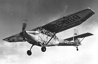
The Stinson L-13 was a US military utility aircraft first flown in 1945.

Shadforth is a village in County Durham, England, a few miles east of Durham. The historic centre of the village is a conservation area. The population at the 2011 census was 2,118.
Crathorne is a village and civil parish in North Yorkshire, England. The parish population was 172 at the 2011 census. The River Leven flows through the parish. The A19 used to run through the village before a dual carriageway was built in 1975. Now the A67 follows the route of the old A19 north towards Yarm.

Villarejo de Órbigo is a municipality located in the province of León, Castile and León, Spain. According to the 2004 census (INE), the municipality had a population of 2,390 inhabitants.

Sena de Luna is a municipality located in the province of León, Castile and León, Spain. According to the 2004 census (INE), the municipality has a population of 450 inhabitants.

Cape Anguille is a headland and the westernmost point in Newfoundland, reaching into the Gulf of Saint Lawrence. It is the southern edge of St. George's Bay. Its name is derived from the French word anguille, which means eel. Close to the cape is the community of Cape Anguille.

The Saint Leonard–Van Buren Bridge is an international bridge, which connects the communities of St. Leonard, New Brunswick in Canada and Van Buren, Maine in the United States, across the Saint John River.
Gouraye is a town and commune in Mauritania, located in the Guidimaka Region.
St. Kryan's is a settlement in Newfoundland and Labrador.
Langue de Cerf was a settlement in Newfoundland and Labrador.
Henningsen Glacier is a glacier 3 nautical miles (6 km) long, flowing southwest to the south coast of South Georgia between Cape Darnley and Rocky Bay. It was surveyed in the period 1951–57 by the South Georgia Survey expedition led by Duncan Carse, and was named by the UK Antarctic Place-Names Committee for Leonard Henningsen, Manager of Tønsbergs Hvalfangeri, Husvik, 1945–50.
Division No. 1, Subdivision B is an unorganized subdivision on the Avalon Peninsula in Newfoundland and Labrador, Canada. It is in Division 1 and contains the unorganized communities of Iona, Little Barasway, Placentia Junction, Point Verde and Ship Harbour.
Division No. 1, Subdivision C is an unorganized subdivision on the Avalon Peninsula in Newfoundland and Labrador, Canada. It is in Division 1 and contains the unincorporated communities of Cape St. Mary's, Cuslett, Gooseberry Cove, Great Barasway, Lears Cove, Patrick's Cove-Angels Cove, Ship Cove and Stoney House.

St Mary's Church, Bow was a Church of England parish church in Bromley St Leonard's in east London. 'Bromley St Leonard's' was split from the parish of Stepney in 1536, reusing the priory church from the recently dissolved St Leonard's Priory, a Benedictine nunnery. It contained significant monumental sculpture.
